
A translation of this article was made possible by a partnership with Planeteando. Una traducción de este artículo fue posible gracias a una asociación con Planeteando.
On 21 December 1994, Claus Siebe was sleeping at a friend’s house at the foot of Popocatépetl, one of the massive stratovolcanoes that dominate the skyline in central Mexico. He had plans to climb Don Goyo (as it’s known by the locals) with his volcanology colleagues from the Geophysics Institute of the National Autonomous University of Mexico (UNAM), but those plans were soon canceled. The Sun was beginning to rise when his friend excitedly dragged Siebe out of bed. The volcano was awake.
“Finally,” he remembers thinking as he walked out of his friend’s house in the town of Atlautla, Puebla, and saw a column of ash rising from the volcano’s crater.
Siebe wasn’t alone as he made his way to the volcano. Popocatépetl had been inactive for decades and had become a destination for hikers who wanted to climb its glacier. When Siebe arrived at the last shelter accessible by car, he saw many such visitors descending the mountain, frightened. The rest looked at Don Goyo in awe. It was the first time in their lives that they had seen the volcano do such a thing.
In the months that followed, volcanologists from Mexico and the United States worked quickly to provide a hazard map for Popocatépetl that could inform civil protection authorities in the three states that could be affected by the volcano’s activity: Morelos, Puebla, and Tlaxcala. José Luis Macías, who had just been hired at the Geophysics Institute in 1994 and is now its director, recalled that the first version of the map was created in “record time.”
Preparing for an Eruption
The map may have been produced quickly, but the preparation had begun years earlier. The few volcanologists working at UNAM suspected that something was happening at Don Goyo as far back as 1990, when visible fumaroles appeared at its crater.
These signals motivated some scientists to contact the Mexican authorities. In 1993, Siebe and his colleague Hugo Delgado shared their findings with then undersecretary of government Socorro Díaz Palacios. Both researchers remember her response was not immediate; she asked for proof of major volcanic activity.
Siebe decided to ask for help from his friend Stanley Williams of Arizona State University. Williams, however, was recovering from an injury received during the eruption of the Galeras volcano in Colombia and was unable to travel.
Instead, Williams sent Tobias Fischer, his student at the time and now a professor at the University of New Mexico. Fischer traveled to Mexico with a device called a correlation spectrometer (COSPEC), which measures an area’s concentration of gases by analyzing how the gases respond to a beam of light.
Researchers did not know when Popocatépetl would wake up, but they began to prepare for that moment.
On 1 February 1994, Fischer climbed into a small plane to fly around the volcano and pointed the COSPEC at Don Goyo. What he found was that “the sulfur dioxide readings were not high, but very high,” Siebe recalled. Williams added that “the measurements of several thousand metric tons of SO2 [sulfur dioxide] per day was the first measurement of a state of eruption of Popo, rather than it being simple unrest of the volcano. It resolved the debate about the activity.”
The sulfur readings were a warning. The volcanologists at the Geophysics Institute did not know when Popocatépetl would wake up, but they began to prepare for that moment. They quickly went into the field to study volcanic deposits left by past activity. Evidence of avalanches, lava flows, and lahars (flows of ash and water that form a concrete-like mud) surrounded the volcano.
In December 1994, Delgado went to the University at Buffalo in New York to run some simulations with data he and his colleagues had collected over the year. The goal was to get some predictions of different eruption scenarios “that would allow us to see what the likely distribution of materials would be and what the maximum extent of those materials” would be, Delgado explained.
He was on a stopover on his way back to Mexico when he learned that Popocatépetl had started to erupt.
After the Eruption
After Popocatepetl’s eruption event, “financial support began to be available not only for research projects but also for the purchase of instruments.”
After the eruption, conversations resumed between scientists and representatives of the federal government (this time with the new undersecretary of government, Eduardo Medina-Mora). At the new meetings, Macías recalled, the government’s attitude toward the volcano’s importance changed.
Macías explained that after Popocatépetl’s 21 December eruption event, “financial support began to be available not only for research projects [associated with the volcano] but also for the purchase of instruments.” These initiatives were the beginning of organized, permanent monitoring of the volcano, a program that will celebrate 30 years of operations in 2024.
With increased funding from the Mexican government, the first scientific advisory committee was formed in 1995 and included volcanologists from UNAM and the U.S. Geological Survey. Its first task was to develop a hazard map for Don Goyo.
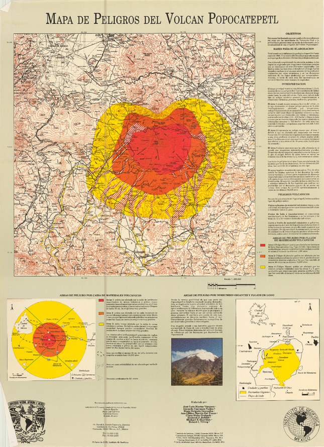
The first step was to analyze the 25,500 years of eruptive history of Popocatépetl and decide which events were relevant to help identify high-, moderate-, and low‑hazard areas for pyroclastic flows, lava flows, projectiles, landslides, and lahars.
The low‑hazard designation corresponds to scenarios less likely to happen, but with the greatest impact when they do. The most familiar low-hazard events are known as Plinian eruptions, and there have been two recorded at Popocatépetl in the past 40,000 years. The last one occurred between 822 and 823 CE, according to a 1996 paper by Siebe.
The high‑hazard designation, on the other hand, corresponds to scenarios of small eruptions that happen more frequently.
In between the two, the moderate‑hazard designation corresponds to big eruptions that volcanologists identified as occurring at least 10 times over the past 15,000 years.
Mapping the Hazards
Lahars have the most extensive hazard area, the scientists concluded. Research published in the journal Ciencias, for instance, describes how mudflows produced in the last Plinian eruption were probably responsible for the fall of the pre-Hispanic city of Cholula, flooding the terrain and rendering it useless for agriculture. Evidence of this phenomenon was found near the base of a pyramid approximately 34 kilometers from the Popocatépetl crater. (More than a thousand years later, however, the effects of the devastating lahars are responsible for the high fertility of the soil around the pyramid and Popocatépetl.)
Once the lahars and other hazards were mapped, civil protection authorities in nearby states were able to design evacuation routes and establish protocols.
Integrating Science Policy in Government Action
The volcano’s initial scientific advisory committee was the first of its kind. The group was not convened by any law or regulation, but in 2012, when a new General Civil Protection Law was enacted, volcano and other scientific advisory committees were officially included to “support the authorities in diagnosis and decision-making in risk management in order to minimize possible damage.”
In addition to scientists and policymakers, the hazard map was also a valuable tool for Nahua Indigenous communities in Morelos, Puebla, and Tlaxcala. Throughout the early 2000s, these communities used the law to resist a pipeline project that transected traditional Nahua land across the three states.
In fact, several kilometers of the proposed pipeline crossed Popocatépetl hazard zones that had been recently mapped. Ana Lillian Martín del Pozzo, along with her UNAM colleague Macías, advised pipeline developers “that this was an area prone to this type of phenomenon [lahars and pyroclastic flows] and that it would be advisable to build it further away,” she said.
Indigenous and other communities sued to halt construction of the pipeline. Ultimately, a court decided the project should have consulted with Indigenous communities before construction began. But by the time the judge ruled, the pipeline had already been built.
Although the hazard map proved to be useful for disaster preparation, response, and mitigation, its authors knew it was a preliminary work.

Researchers needed more geological information, so instances of fieldwork around the volcano increased. Macías remembers a big spike in journal articles about Don Goyo in the late 1990s. The Geophysics Institute also began to change. The school’s postgraduate program in Earth sciences was created in 2000, and just a year later, the institute had an independent Department of Volcanology.
Informed by advanced technology and more studies on Popocatépetl, the most updated version of the hazard map was published in 2016.
The volcano and its hazard map remain active. In 2023, Popocatépetl once again captured the world’s attention when it began spewing smoke and ash, triggering a Yellow Alert. The eruption’s shock wave made the windows of nearby houses rattle gently, school was canceled, and airports in nearby Mexico City and Puebla were temporarily shut down.
—Roberto González (@ggonzalitos), Science Writer