

An Earth-watching instrument scheduled for launch in early April will measure air pollution at “neighborhood” resolution across almost all of North America. It will help scientists spot and track sources of air pollution, improve air quality forecasts, and zoom in on wildfires and other environmental hazards.
Tropospheric Emissions: Monitoring of Pollution (TEMPO) is a joint project between NASA and the Smithsonian Astrophysical Observatory. It will enter a geostationary orbit, roughly 35,800 kilometers above the equator at 91°W longitude, aboard the Intelsat 40e communications satellite.
The new instrument’s ultraviolet and visible light spectrometer will scan the continent from east to west once every hour from sunrise to sundown, logging levels of ozone, aerosols, and other pollutants. The fine resolution will provide critical information on natural and human-caused changes in air quality over day-night cycles and seasons.
“TEMPO will be revolutionary.”
“TEMPO will be revolutionary,” said Aaron Naeger, a research scientist at the University of Alabama in Huntsville and deputy program applications lead for TEMPO. “It will be the first satellite to provide early morning to early evening observations of the atmosphere. It will measure the entire air column, from the satellite to the ground, so it will monitor air quality in this layer of air where people live and breathe.”
Measuring Pollution at Presto Tempo
Earlier pollution-monitoring satellites, which move in polar orbits, scan “curtains” of the atmosphere once a day, near local noon, said Jun Wang, a chemical and biochemical engineer at the University of Iowa and a TEMPO scientist. However, these measurements are coarse in space and time. “From only a few curtains, you don’t know much about everything in between.”
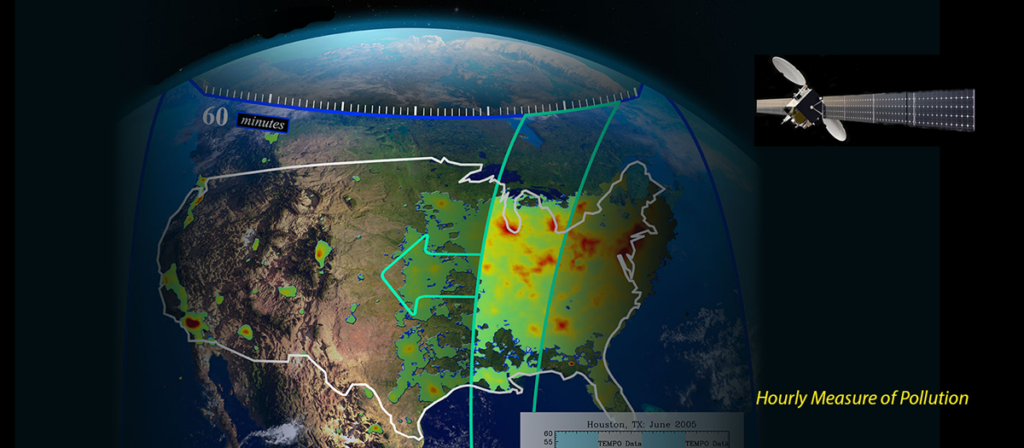
TEMPO, on the other hand, will provide spatial resolution as fine as 2.1 (east–west) by 4.5 (north–south) kilometers—neighborhood scale, Naeger said—with an altitudinal resolution of 200 to 500 meters. It does this once per hour, speeding past the tempo of earlier devices.
Atmospheric scientists will use these fine-scale observations to refine models of how the atmosphere circulates these compounds throughout the day, helping them provide better air quality forecasts on both regional and local scales.
Such forecasts may help patients, health care providers, and local officials, said Susan Alexander, a professor of nursing at the University of Alabama in Huntsville and an “early adopter” of TEMPO science. “We already have air quality forecasts, but if we know that air quality will be reduced on an even more localized scale, perhaps we can do more to prepare. We might cancel some outdoor activities or encourage people with respiratory problems to stay indoors. There are even implications for facilities—staffing, purchasing supplies. There are all kinds of possibilities.”
Almost 50:50 Split
The instrument will monitor ozone, which can exacerbate respiratory and other health problems. It will measure the entire atmosphere, from ground to satellite, but it will focus on the bottom 2 kilometers of the troposphere, which are home to life.
Ozone is produced by burning fossil fuels, primarily for transportation, so its concentration should fluctuate dramatically during the day as urban traffic waxes and wanes. Ozone is associated with other pollutants, such as nitrogen dioxide and formaldehyde, which TEMPO will track as well, along with sulfur dioxide, aerosols, and water vapor (a greenhouse gas).
TEMPO will also monitor pollutants pumped into the air by the agriculture industry. “Through the years, urban transportation emissions have been declining because of regulations…but when farmers add fertilizers to their crops, organisms in the soil decompose them and emit trace gases. One of those is nitrogen dioxide, which is a precursor to ozone,” Wang said. In fact, in an earlier study, he showed that in California, nitrogen dioxide emissions from soil were on par with those from transportation. “It was almost a 50:50 split.”
Although TEMPO will record continent-wide pollution throughout most days, part of its observation time will be reserved to zoom in on “special” events, including wildfires, volcanic eruptions, industrial accidents, and dust storms. Western wildfires are of particular concern because they are becoming larger and more common, and their pollution reaches far beyond the fire zone.
Scientists expect that the instrument will be able to target such events in as little as an hour and provide observations every 10 minutes. Those observations (along with the rest of TEMPO’s data set) should be available to everyone, from scientists to firefighters, within about 2 hours of acquisition.
No Boundaries in the Atmosphere
The three missions will work together to provide a more complete picture of how pollutants travel around the entire Northern Hemisphere.
TEMPO will begin full science observations in August, after a 4-month commissioning period (although it will be able to watch special events during that time). It is certified for at least 2 years of observation. Intelsat 40e has a planned 15-year lifetime, however, so TEMPO could keep scanning North American skies well beyond its planned lifetime.
It will be the second of three new continent-watching environmental satellite projects. South Korea launched one called the Geostationary Environment Monitoring Spectrometer (GEMS) in February 2020, with Europe scheduled to orbit another, Sentinel-4, in 2024. The three missions will work together to provide a more complete picture of how pollutants travel around the entire Northern Hemisphere.
“There are no boundaries in the atmosphere,” Wang said. “The air goes around, the air comes around.…We want to understand that long-range transport.”
—Damond Benningfield, Science Writer
This news article is included in our ENGAGE resource for educators seeking science news for their classroom lessons. Browse all ENGAGE articles, and share with your fellow educators how you integrated the article into an activity in the comments section below.