
Toppled trees can tell the story of a windswept landscape, if only people know how to tune in. Now, researchers are reading the roughness of hillsides to learn about winds blasting in the past.
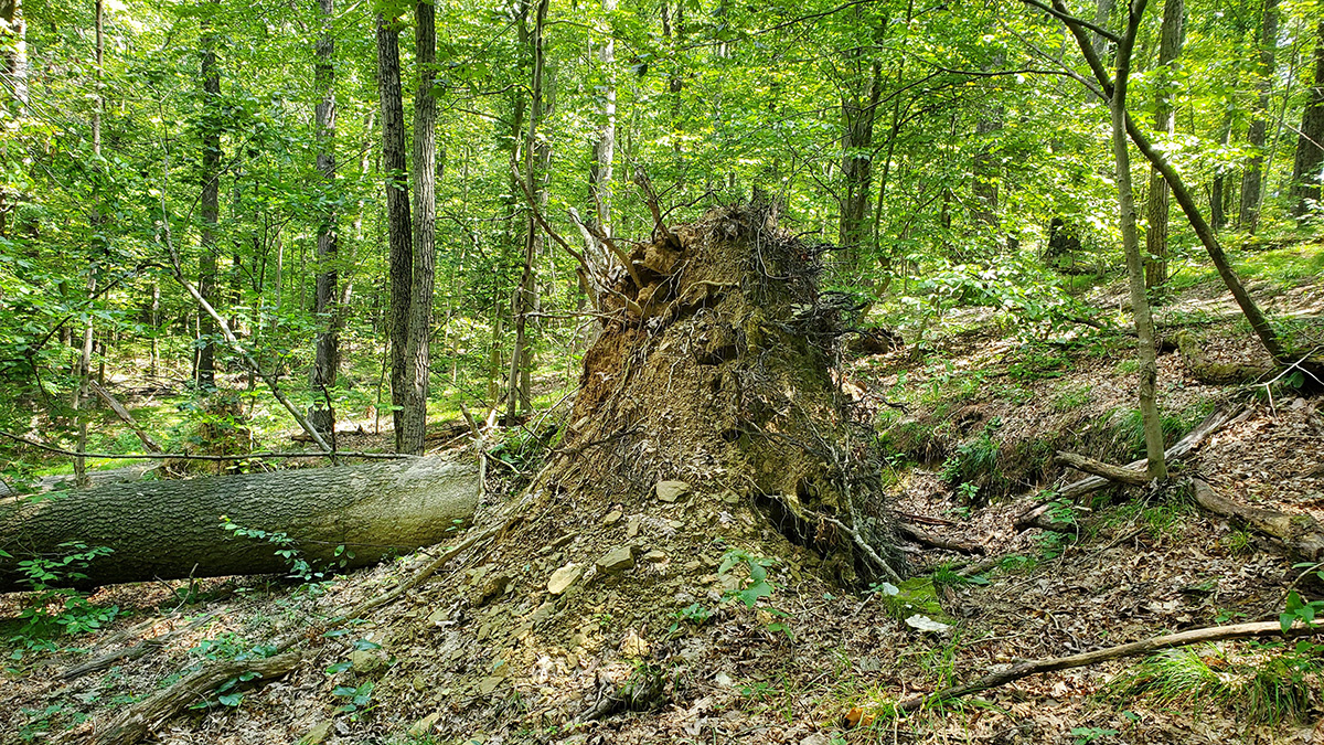
“All the little bumps that you see in a forest are some record of a past event,” said Tyler Doane, a geomorphologist at Indiana University Bloomington. The features are born through a process called windthrow, which happens when high winds push a tree on a slope over. The force wrenches the roots from the ground, leaving behind a pit in the ground and a mound of soil and rock next to it.
Windthrow events affect ecosystems in a variety of ways. They create microhabitats, for instance, by collecting moisture in pits that can support amphibians such as salamanders. They shuffle carbon around, pulling it from storage in the tree and releasing some to the atmosphere as the tree rots. Windthrow can make the ground more porous and free up soil to move downhill.
But these events are rare, and figuring out how often they happen is tricky. So Doane and his colleagues looked to the land to see whether it could reveal past windthrow.
Windthrow makes pits and mounds, which are later smoothed by processes such as worms and other critters creeping through the soil or pockets of ice freezing and thawing. There’s a “balance between the fluffing of the landscape by wind and the smoothing of the landscape over time as sediment is moved from these mounds,” said Jill Marshall, a geomorphologist at the University of Arkansas in Fayetteville.
“The rougher the hillslope, the more frequently windthrow happened.”
Doane and his colleagues scoured lidar data from 1,400 hillslopes in southern Indiana’s Brown County, collected by the U.S. Geological Survey in 2017. Lidar sees through the forest’s trees, revealing the bare landscape. Past windthrow events look like pockmarks dotting each slope.
From the roughness of the forest floor and prior knowledge of how quickly the area’s windthrow-formed pits and mounds decay, the team estimated how often windthrow happens. “The rougher the hillslope, the more frequently windthrow happened,” Doane said.
Next, the researchers investigated how brutally the wind battered the forest’s trees over time. Using an hourly record from a nearby site of wind speeds from 2000 to 2020, they estimated how likely certain wind speeds were to occur. Coupling the result with knowledge of windthrow frequency from the forest roughness, they calculated how strong trees needed to be to stay upright.
A tree will resist wind pushing against its trunk and branches until the force is too strong for the roots to cling to the ground. With an understanding of the forces at work, researchers modeled the probability of windthrow in Brown County’s hills across a range of wind speeds.
Tree-Tossing Winds
Under typical wind speeds in this forested Indiana county, some 0.1 to 1.6 trees per hectare topple each year because of windthrow, the team reported in the Proceedings of the National Academy of Sciences of the United States of America.
Though the numbers are specific to Brown County, the team’s approach could be applied to other places that have moderately sloping hills. “This [research] serves as a really nice primer of how you can look across really big landscapes and infer the past,” said Marshall, who was not involved in the study.
“Once you start looking for these things, you will see them everywhere.”
Doane and his colleagues are already planning similar work that focuses on other sites in the eastern United States that have moderately sloping hills, as Brown County does. In places with very steep hills, landslides and rockfall could also rough up the ground and complicate the analysis. But the lidar-based approach may also work in coastal areas, where scientists could study how historical hurricanes have uprooted trees, Doane said.
The team also estimated how changes in wind speeds under climate change could alter windthrow frequency in the area. The speediest gusts, blowing 3% faster on average, could lead to nearly 40% more trees being pushed over in a given year. The analysis is somewhat simplistic, Marshall cautioned, as many factors other than wind—such as species distribution and drought conditions—may change along with the climate. Still, “just a small increase in wind can have really big impacts,” she said.
The team also wants to map individual pit-mound pairs across the land. That could help them train computers to look for rough spots, speeding up the process as they take their approach to wider swaths of land. There may be several million pit-mound pairs in Brown County alone, Doane said. “Once you start looking for these things, you will see them everywhere.”
—Carolyn Wilke (@CarolynMWilke), Science Writer
This news article is included in our ENGAGE resource for educators seeking science news for their classroom lessons. Browse all ENGAGE articles, and share with your fellow educators how you integrated the article into an activity in the comments section below.