Eating breakfast at noon may seem like a cushy way to live, but not when you’re about to start your 12-hour shift operating heavy machinery.
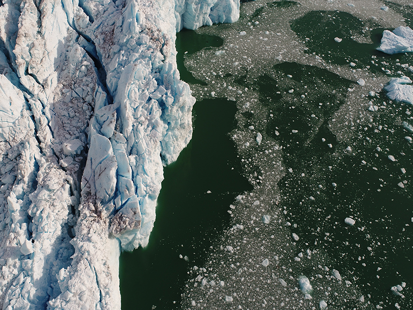
On a boat. Several hundred meters away from a cliff of ice. Ice that periodically rains down in shards.
These were the dangers that University of Oregon oceanographer David Sutherland and his team of scientists faced as they studied the terminus of an actively calving tidewater glacier off the coast of southern Alaska. In such conditions, “you don’t have time to think about being tired or cold,” Sutherland said. “It’s time to just do it.”
Sutherland’s “just do it” refers to collecting as much data as possible about the underwater environment in front of Alaska’s LeConte glacier. Using a suite of instruments, from multibeam sonar to airborne drones, Sutherland and his team were the first to collect data about ice above and below the ocean’s surface while simultaneously collecting data about the activity of the water itself at the frigid boundary where glacier meets sea.
Specifically, the team, which included scientists from Oregon State University and the University of Alaska Southeast, sought to understand the river of meltwater leaking from the bottom of LeConte glacier into the sea, meltwater that rises as a relatively warm plume and may exacerbate the rate at which the glacier melts. The data will help scientists in their quest to make sense of climate change at a granular level.
Sutherland, who co-leads the research team, will review the progress of the group’s field campaigns and present preliminary findings this afternoon at the American Geophysical Union’s 2017 Fall Meeting in New Orleans, La.
Rivers of Questions
Alaska’s LeConte glacier is the Northern Hemisphere’s southernmost tidewater glacier, a class of glaciers that terminate at the sea. Most tidewater glaciers stay grounded, but sometimes the glaciers develop a floating tongue over seawater. These glaciers are known to have cyclical behavior: steady advance followed by drastic retreat.
LeConte acts as the perfect analogue for ice in other parts of the world that extends over seawater but is grounded to land, Sutherland said. As such, finely scaled surveys at LeConte, he hopes, could be key to unlocking secrets of the tidewater glacier cycle, including whether ice that spreads from land into the sea could melt completely as Earth’s atmosphere continues to warm.
For example, to what extent could massive ice sheets of Greenland and Antarctica be vulnerable? The West Antarctic Ice Sheet alone could add 3 meters to future sea levels if it completely collapses, Sutherland notes.
However, scientists can’t easily travel to Antarctica or Greenland, which is why LeConte glacier in Alaska is perfect: The glacier hosts features similar to and the same physics as those in Antarctica or Greenland but on a smaller scale, Sutherland said. The large data set the team collected “will allow us to look at some of these really short timescale processes that we aren’t able to investigate in other parts of the world,” he continued.

In addition, Alaskan field campaigns are decidedly more pleasant. Although it can get rainy, temperatures generally hover between 40°F and 50° F. Researchers are able to interact with residents of Petersburg, a small town nearby where everyone owns a boat and wedding receptions are open to all.
“The best thing about working in Alaska instead of Greenland or Antarctica is that it’s so much more alive,” Sutherland said. “In Greenland, scales are bigger, the icebergs are bigger, the glaciers are bigger, the mountains are bigger…but everything is very stark.”
Subglacial Melt
At the top of a glacier, the Sun melts water into rivers and pools. Over time, gravity forces the water downslope; these minirivers drain through the glacier’s cracks and crevices (sometimes even forming caves). The river eventually escapes at the glacier’s grounding line, where the bottom of the glacier meets ground.
For a glacier like LeConte, this grounding line sits underwater. Because the meltwater is less salty than the ocean water it encounters, it rises as a plume. But in the fjord at the glacier’s outlet, “bottom waters are relatively warm and salty,” Sutherland explained. So when the subglacial melt plume hits the warm, salty bottom waters, it warms up.
Nonetheless, the plume “still rises because it’s still less dense because of its relative freshness,” Sutherland continued. As it warms and rises, it drags with it some surrounding—and relatively warm—seawater.
The mass of rising, warm water can melt the vertical face of the glacier.
This water can stir up nutrients, which attracts wildlife. But more interesting to Sutherland and his team, the mass of rising, warm water can melt the vertical face of the glacier.
However, the underwater face of a glacier is somewhat of a black box to scientists, Sutherland said, because it’s so logistically difficult to access. Scientists have measured subglacial melt plumes downstream, far after they’d risen and traveled away from a glacier, but Sutherland and his team wanted to get closer and measure the plumes the moment they rose to see how the plumes interacted with the face of the glacier itself.
A Flood of Data
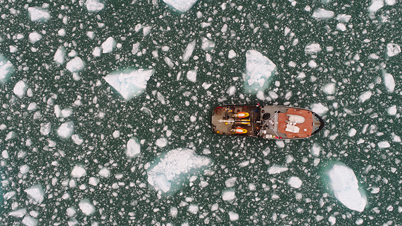
The researchers therefore deployed several different instruments simultaneously to study the unfamiliar environment. For three 10-day research cruises, their vessel, M/V Steller, zigzagged back and forth in front of the glacier several hundred meters away, bombarding its underwater face with sonar chirps. The sonar records the ridges, bumps, and cracks on the glacier’s face, Sutherland said, and multiple passes with the sonar over time tell the team how this face changes as warm plumes rise from below. Other instruments on the main research vessel measure the temperature, salinity, and velocity of the ocean water.
Meanwhile, Oregon State University’s three remotely operated drone boats—two of them named Rosie and Casey, after a local Petersburg couple whose wedding reception the researchers attended during one of the field campaigns—took measurements of the temperature, salinity, and velocity of the water, looking for plumes. These drone boats bobbed just a few meters away from the glacier face and often narrowly missed getting clobbered by falling ice. Luckily, none of the boats sustained lasting damage, Sutherland said.

“What we’re trying to do is measure the actual rising plume with all these ancillary measurements about what the glacial terminus is doing” as the plume rises, Sutherland said. The researchers want to know how the rising plume of relatively warm water affects the rate at which the glacier is melting.
The research team worked in 12-hour shifts—from 4:00 a.m. to 4:00 p.m., 4:00 p.m. to 4:00 a.m., and repeat. Much of the work between shifts was the same: operating instruments to study the temperature and salinity of the water and operating the sonar instrument. The drone boats took nights off, Sutherland said.
The research wasn’t easy; sometimes, masses of ice floating around their research boat impeded movement and threatened their expensive equipment. Sometimes, chunks of ice broke off the glacier and crashed into the water, forcing the team to abort and ride away on the resulting wave.
Secrets in the Data?
Now that the team has finished collecting data, it’s time to begin the analysis. The researchers want to know whether, and how much, ice along the glacier’s front melted because of the plume. Glacial ice disappears for multiple reasons—from melting or calving, for instance—and it can be hard to differentiate among all the ways that glaciers lose ice, Sutherland said.
“These systems have all these things happening at once. They have subglacial discharge, they have active calving,” Sutherland continued. But does some threshold of melt rate trigger calving and potential collapse of the floating tongue of the glacier? What is the melt rate at places that lack active calving?
Current data reveal just the tip of the iceberg, Sutherland noted. So he and his team continue to probe at and in depth.
—JoAnna Wendel (@JoAnnaScience), Staff Writer
Citation:
Wendel, J. (2017), Science at the border between ice and ocean, Eos, 98, https://doi.org/10.1029/2017EO088187. Published on 11 December 2017.
Text © 2017. The authors. CC BY-NC-ND 3.0
Except where otherwise noted, images are subject to copyright. Any reuse without express permission from the copyright owner is prohibited.