A translation of this article was made possible by a partnership with Planeteando. Una traducción de este artículo fue posible gracias a una asociación con Planeteando.
When it comes to volcanoes, Iceland rarely disappoints: From the traditional cone-shaped edifices of stratovolcanoes to magmatic systems hiding under ice and water, the country has it all.
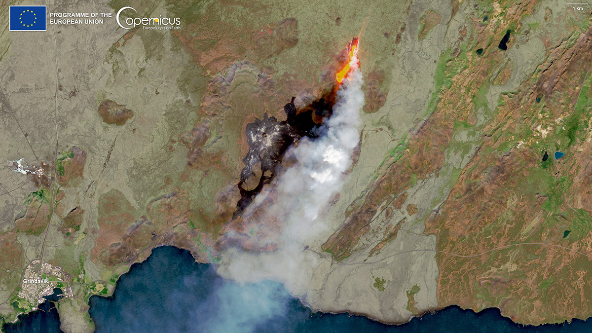
Iceland’s newest volcanic show began just last week, when a fissure in the Fagradalsfjall region on the Reykjanes Peninsula, located about 30 kilometers southwest of Iceland’s capital city of Reykjavík, started erupting on 10 July. Volcanologists, seismologists, and other researchers who study Earth’s interior plumbing have been busy analyzing the ongoing eruption—here’s a rundown of what they’ve learned.
A History of Eruptions
Iceland is situated at the boundary of the Eurasian and North American tectonic plates, which are being ripped apart by roughly 2 centimeters per year. As a result, the country, which is roughly a quarter the size of California, is a hotbed of volcanic activity: Iceland is home to more than 30 volcanoes that have erupted within the past 12,000 years.
The ongoing eruption of Fagradalsfjall follows close on the heels of two others in the same region. The first, which began on 19 March 2021 near the city of Grindavík, persisted for 6 months and ultimately released about 150,000,000 cubic meters of magma. That event ended a long dry spell for the Reykjanes Peninsula—the last volcanic eruption there occurred in the 13th century.
The Fagradalsfjall region erupted again on 3 August 2022 when a new fissure opened on the northern part of the 2021 lava field. But that eruption was short-lived: Within a span of 3 weeks, all volcanic activity had ceased. That’s probably because the magma intrusion wasn’t pulling from a large reservoir of molten rock, said Michelle Parks, a volcanologist at the Icelandic Meteorological Office in Reykjavík. “It was potentially tapping a shallower source.”
The current eruption, which is occurring to the north of both the 2021 and 2022 lava fields, first began emanating from a fissure roughly 800 meters long. Since then, the active site has shrunk to a single vent measuring about 75 meters. To date, fresh lava has blanketed roughly 900,000 square meters of the landscape, 250 times the area of New York City’s Grand Central Station.
Gas and Smoke
Erupting volcanoes typically belch gases. Harmless water vapor is one example, but eruptions also can produce pollutants such as sulfur dioxide (SO2), carbon dioxide (CO2), and hydrogen sulfide (H2S). Within hours of the start of the most recent eruption, researchers had begun measuring the composition and emission rates of the gases emanating from Fagradalsfjall.
“The concentrations we measured in some places…were on par with the pollution measured during annual New Year’s Eve fireworks.”
Ground- and drone-based measurements of H2O, SO2, and CO2 have revealed that the 2023 eruption is chemically quite similar to its 2022 predecessor, said Melissa Anne Pfeffer, an atmospheric volcanologist also at the Icelandic Meteorological Office. Pfeffer and her colleagues also measured an average sulfur dioxide flux of 90 kilograms per second over the first 4 days of the eruption; by 18 July the flux had fallen to roughly 40 kilograms per second. Nearby populations haven’t been affected by the emissions, she said. “The volcanic gases have so far been having relatively little impact on downwind communities.”
What has been a problem, however, is air pollution, Pfeffer said. But volcanic gases aren’t the culprit—it’s smoke. Lava flows have ignited moss, which is prevalent in the Fagradalsfjall region, and the smoke from the resulting fires is leading to poor air quality. On Sunday, 16 July, Pfeffer and her colleagues measured airborne concentrations of both PM10 and PM2.5—particulate matter smaller than 10 and 2.5 microns, respectively. “The concentrations we measured in some places along the hiking path that leads to the eruption were on par with the pollution measured during annual New Year’s Eve fireworks,” Pfeffer said.
Drier-than-usual conditions helped set the stage for these fires, Parks said. Iceland experienced an unexpected dry spell in the week leading up to the eruption, and those conditions primed the landscape for fires, she said. “The vegetation was extremely dry.”
Effusive, Not Explosive
The ongoing eruption is effusive, just like its two most recent predecessors: Lava is dribbling out relatively calmly, and the eruption is not explosively lofting ash and volcanic gases tens of kilometers into Earth’s atmosphere. On 11 July, researchers estimated that lava was being discharged from several small fountains at a rate of roughly 20 cubic meters per second; that rate has since declined by about 25%. For comparison, when Kīlauea erupted explosively in 2018, the Hawaiian volcano discharged more than 100 cubic meters of lava per second.
The quieter nature of the Fagradalsfjall eruptions makes sense because the magma underlying the region has a relatively low silica content, Parks said. “These are basaltic eruptions.” Silica, also known as silicon dioxide (SiO2), increases the viscosity of magma, which in turn makes it more difficult for gases trapped within the molten rock to escape and leads to the buildup of pressure.
Seismic Activity Was a Precursor
Seismic activity is a common precursor to volcanism—the rumblings are caused by magma and other volcanic fluids moving within Earth’s crust. Earthquakes started rolling through the Fagradalsfjall region on 4 July, nearly a week before the most recent eruption began.
By mapping where earthquakes occur in 3D space, it’s possible to trace the movement of magma. And those early temblors spelled out an unambiguous pattern, Parks said. “It was clear from the seismicity that we saw an upward migration, from a depth of about 8 kilometers to a depth of 4 or 5 kilometers.” Since then, thousands of temblors have been recorded, including more than 30 that topped magnitude 4.0. The largest, at magnitude 5.1, occurred the night before the eruption.
“I will retire and this activity will be ongoing.”
Researchers can use patterns in seismic data to predict when volcanism will occur. It’s common for seismicity to decrease immediately preceding an eruption: As magma moves upward on its journey to the surface, it encounters weaker crust that’s less capable of storing tectonic stress, scientists believe. Researchers observed an overall downturn in seismicity in the days leading up to Fagradalsfjall’s 10 July eruption. That observation, Parks said, helped forecast that the likelihood of an eruption was high.
But seismic data have their limits: It’s not possible, for instance, to predict the duration of an eruption based on seismic measurements, Parks said. “It is very difficult to estimate the length of these eruptions if they are being fed by a deeper source near the crustal-mantle boundary.”
Scientists in the Icelandic community and beyond are busy collecting data from Fagradalsfjall. The ongoing measurements will paint a better picture of volcanism in Iceland, said Parks, and this current eruption will no doubt be followed by many, many more. “I will retire and this activity will be ongoing.”
—Katherine Kornei (@KatherineKornei), Contributing Writer