Debuting this fall, a new online tool will identify in near-real time areas across the world where rainfall-triggered landslides are most likely to occur. The lead researcher on the Landslide Hazard Assessment Model for Situational Awareness, or LHASA for short, described the new “nowcast” publicly for the first time last week at the Geological Society of America annual meeting, in Denver, Colo.
“It’s the first type of system of its kind, for better or worse,” said research scientist Dalia Kirschbaum of the NASA Goddard Space Flight Center in Greenbelt, Md. “It’s meant as a tool to get a broad-brush understanding of potential areas of landslide activity…and it is a demonstration of how remote sensing data can be used at a global scale.”
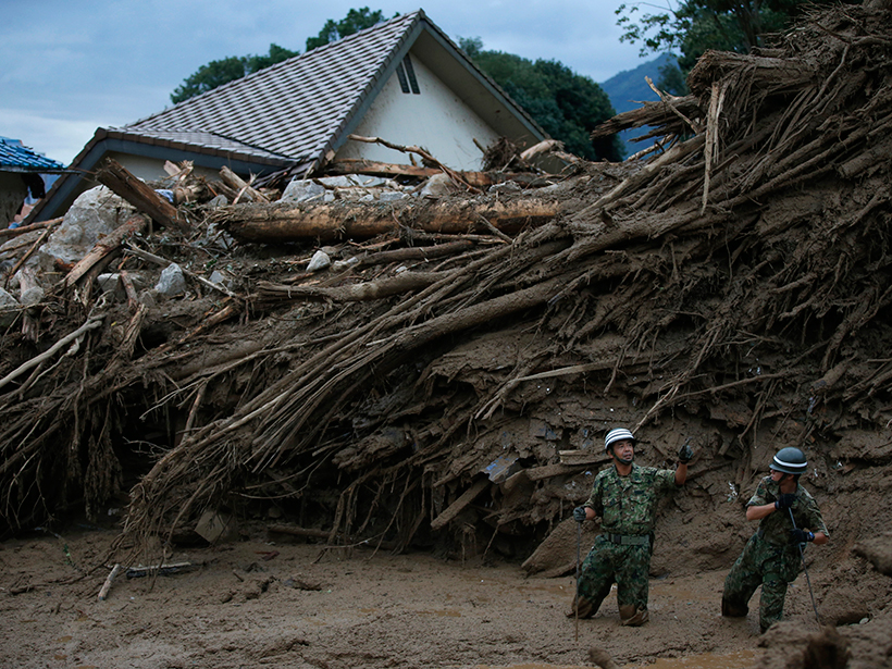
Rainfall-triggered landslides pose significant threats to life and property. Between 2007 and 2015, 7,000 rainfall-triggered landslides killed over 25,000 people and injured another 2,000, according to NASA’s Global Landslide Catalog. However, according to NASA Goddard scientist Thomas Stanley who also works on the catalog, these are almost certainly underestimates of the damage because they rely on English language media reporting for details.
In addition to the loss of life, landslides cause billions of dollars of damage; in the United States alone, the U.S. Geological Survey (USGS) conservatively estimates that landslides generate $2–$4 billion in annual damages. Given these threats, there is a clear need for systems that highlight areas at risk from landslides, particularly in regions where data and communications are limited, Kirschbaum said.
Tracking Risk with Satellites
Wedding remote sensing measurements to complex computer programming, LHASA identifies areas susceptible to landslides around the world on the basis of a suite of environmental variables, including topography, geology, road networks, fault zones, and forest loss. The model also tracks the preceding 7 days of precipitation at those locales using the Global Precipitation Measurement (GPM) satellite network.
Updating every 30 minutes, the system responds quickly to changing conditions.
When rainfall is high in susceptible areas, either cumulatively for the week or for the current day, the system issues a nowcast alert—a term borrowed from meteorology—that identifies areas with a high or moderate landslide probability. Updating every 30 minutes, the system responds quickly to changing conditions but can’t predict landslides, according to Kirschbaum.
Although LHASA is not the only landslide alert system in the world, it’s the first and only system to attain a global reach, Kirschbaum said. Places like Japan and Hong Kong utilize high-tech landslide alert systems, and the USGS has experimented with a system in the Bay Area, but these only operate on a regional scale.
Pros and Cons of the Broad Brush
Other hazard scientists gave the new model mixed reviews in interviews with Eos.
Geographer and landslide expert David Petley at the United Kingdom’s University of East Anglia, called the model “an excellent development for identifying potential problems across a region. … It will permit wide-area analysis and preparedness and marks a step toward better understanding [landslide hazards].” Petley is the author of The Landslide Blog, an editorially independent blog hosted by the American Geophysical Union, publisher of Eos.org.
However, he noted that because the model depends on satellite data limited to 1-kilometer resolution, it could miss finer-grain conditions and events that cause many landslides, like degraded slopes or highly localized heavy rainfall. Nevertheless, the model’s assessments should increase the chances of recognizing pending landslides in remote locations, where communications are difficult, and thereby improve rescue response, he said.
Only time will tell if response and aid agencies find the nowcasts helpful.
Landslide hazards coordinator Jonathan Godt, of the USGS Geologic Hazards Science Center in Golden, Colo., noted that nothing currently provides a comprehensive understanding of where rainfall-triggered landslides occur around the world. By collecting and displaying landslide-related information across the whole spectrum of climates and geological settings, the model will likely help researchers better understand these hazards. But, he cautioned, only time will tell if response and aid agencies find the nowcasts helpful.
Godt also echoed a weakness of the new system that Kirschbaum had mentioned to Eos—the potential for overlooking contributions of gradual or seasonal rainfall to landslides. For example, both noted, the landslides in Oso, Wash., in 2014 were partly caused by weeks of rain and degraded hillslopes. The model, which does not factor in ground saturation, would likely not have identified the hazard as the soil slowly soaked up the rain.
Toward Forecasts?
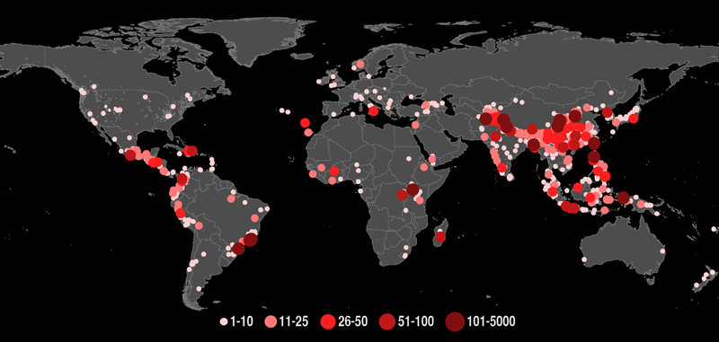
The development of LHASA culminates many years of research into rainfall-triggered landslides. Since 2007, Kirschbaum and her team have compiled a database of landslides around the world. The Global Landslide Catalog—which is used to calibrate LHASA—contains more than 8000 landslides documented from media reports, online disaster databases, and other sources. The model also incorporates the primary elements from Kirschbaum’s previous work, a regional model for Central America and the Caribbean.
Kirschbaum concedes that model has limitations, but she is hopeful that it can provide a big-picture view and fill in data gaps for far-flung reaches of the planet. Ideally, she told Eos, a global model would combine highly focused regional models, but given the dearth of landslide data and in situ service data in some regions, that is not possible.
As Kirschbaum anticipates the public release of the model—it is scheduled to go live this fall—she is already plotting her future ambitions for the project. She said she hopes to develop a citizen science effort to further bolster the landslide catalog. She would love to see the model, which was developed as open source software, adopted and improved upon, eventually allowing scientists to forecast landslides before a storm even hits.
That will have to wait until a later date, however. “There are a lot of lofty goals,” Kirschbaum said. “But this is the first step.”
—Aaron Sidder, Freelance Science Writer; [email protected]
Citation:
Sidder, A. (2016), Tracking landslide hazards around the world, pixel by pixel, Eos, 97, https://doi.org/10.1029/2016EO060583. Published on 06 October 2016.
Text © 2016. The authors. CC BY-NC-ND 3.0
Except where otherwise noted, images are subject to copyright. Any reuse without express permission from the copyright owner is prohibited.