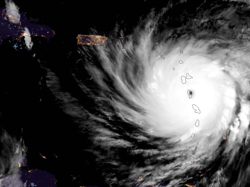
On top of powerful winds and flooding, there was darkness. It came when the entire island of Puerto Rico lost power after Hurricane Maria’s onslaught Wednesday. The category 4 storm’s winds ripped through Puerto Rico starting around 7 a.m. Eastern time that morning, after barreling through Guadeloupe and Dominica, causing widespread damage and flooding. By late the same night, Hurricane Maria was gone from Puerto Rican territory. It left at least 10 dead in its wake.
[VIDEO] Río Guayama se sale de su cause por lluvias de #HuracanMaria pic.twitter.com/fqgWrPJevK
— Radio Isla 1320 (@radioislatv) September 20, 2017
By the next morning, the National Hurricane Center reported that the storm, category 3 by then, was heading toward the Dominican Republic, the Turks and Caicos Islands, and the southeastern Bahamas, with wind speeds sustained at 185 kilometers per hour (115 miles per hour).
Hurricane Maria is the third to make landfall as a category 4 this hurricane season: First, Hurricane Harvey slammed into the Gulf coast in late August, causing widespread damage to southeastern Texas and small coastal towns. Then Irma swept over several Caribbean islands earlier this month, destroying much of their infrastructure before landing in south Florida and killing at least 42.
The storm Maria, meanwhile, formed last weekend in the Atlantic as a tropical depression and then intensified into a category 5 storm within just 2.5 days.
#Maria has only been around for four days, but it has left a record-breaking trail of carnage across the Eastern Caribbean. pic.twitter.com/Iods054lkf
— Brenden Moses (@Cyclonebiskit) September 20, 2017
El Niño Versus La Niña?
There is only one other year in recorded history that two category 4 hurricanes made landfall in the United States in one season. This year, there have been three so far.
This hurricane season, although predicted to be above average before it started on 1 June, is already shattering records. Irma and Jose were the first Atlantic hurricanes to simultaneously sustain wind speeds greater than 240 kilometers per hour (150 miles per hour). Harvey dumped record-breaking rainfall on southeastern Texas. Meteorologist Eric Holthaus pointed out that there is only one other year in recorded history that two category 4 hurricanes made landfall in the United States in one season—1992’s Andrew and Iniki. This year, there have been three so far.
Just one other year in recorded history has there been two U.S. Cat 4+ landfalls (1992, Andrew & Iniki). There’s been three in 2017 (so far) https://t.co/HSGfAk9dN1
— Eric Holthaus (@EricHolthaus) September 20, 2017
So what’s going on? Climatologist Jill Trepanier from Louisiana State University in Baton Rouge suggests that this overactive hurricane season could be a result of the globe shifting out of an El Niño, which is characterized by warm waters in the equatorial Pacific Ocean.
During the few years of an El Niño, atmospheric pressures over the Pacific even out, resulting in less chaotic winds and warmer waters there but increasing wind activity in the Atlantic Ocean. But when El Niño ends, the pressure gradients in the Pacific return, bringing with them wind and choppy waters.
All the energy focused on the Pacific leaves the Atlantic Ocean calmer, Trepanier said. This increases the likelihood of Atlantic hurricanes because they need a calm environment to form and grow. That may seem counterintuitive, she noted, because hurricanes are so energetic and destructive. However, winds blowing in relatively the same direction at relatively the same speed allow a symmetrical cyclone to form rather than breaking it up as it travels across the water.
Next year, if the globe enters a La Niña—which exacerbates the increased pressure gradient over the Pacific and solidifies calm conditions in the Atlantic—we could be in for an even more active hurricane season, Trepanier said.
Caribbean wind shear is at its lowest since 2010, w/ a notable drop since August. Coincidence this also aligns with a budding La Niña? pic.twitter.com/EdrjvBig4T
— Michael Lowry (@MichaelRLowry) September 19, 2017
However, she noted, scientists can’t say yet whether a La Niña is on the way.
—JoAnna Wendel (@JoAnnaScience), Staff Writer
Citation:
Wendel, J. (2017), Unprecedented hurricane season sees widespread damage, Eos, 98, https://doi.org/10.1029/2017EO082913. Published on 22 September 2017.
Text © 2017. The authors. CC BY-NC-ND 3.0
Except where otherwise noted, images are subject to copyright. Any reuse without express permission from the copyright owner is prohibited.