Editors’ Highlights are summaries of recent papers by AGU’s journal editors.
Source: Journal of Geophysical Research: Earth Surface
While some landslides can fail catastrophically, many landslides move downslope slowly and can do so for thousands of years. However, even these slow landslides can sometimes catastrophically fail. Theory and observations suggest that such landslides will experience “creep bursts”, an acceleration of the rock mass downslope, that can be measured before they fail. Identifying these creep bursts and understanding the mechanisms that cause them is therefore essential to assess and mitigate hazards associated with slow landslides.
Aspaas et al. [2024] use a unique array of observations from the Åknes landslide, a 0.5 x 1 kilometer landslide in Norway that moves at around 6 centimeters/year. For 11 years, observations have been collected from meteorological and GPS stations on the landslide, as well as instruments within a series of boreholes that reach all the way through the landslide, through the sliding plane (“shear zone”) and into the intact bedrock.
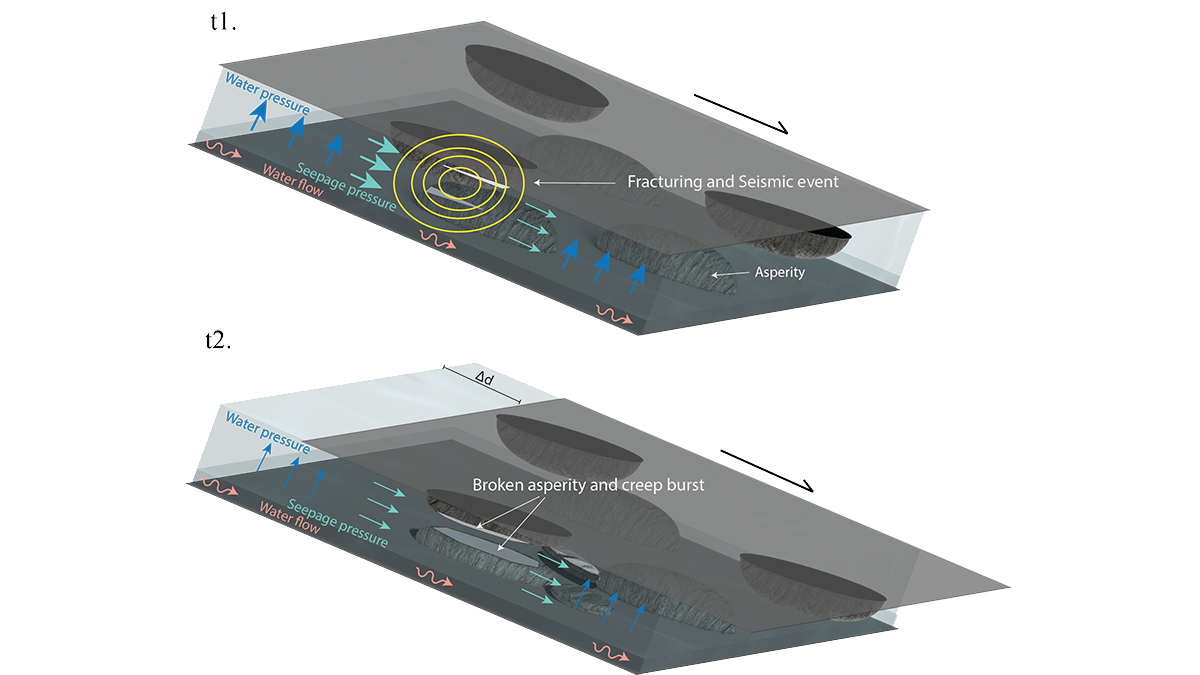
The data show that some creep bursts occur across the whole landslide, associated with increasing water pressure and micro-earthquakes along the shear zone, consistent with what would be expected from theory and observations. However, most creep bursts occur randomly and in one or two boreholes at a time, suggesting that patches of the landslide move independently at times (see image above). Importantly, many creep bursts detected by the instruments in the boreholes are not captured by the instruments at the surface. These observations suggest the presence of asperities that are on the order of 100 meters in size along the sliding plane, which cause the patchy displacement.
This work shows that creep bursts may often go undetected (if landslides are monitored only using surface sensors) and occur more often than thought. It suggests that the mechanisms typically used to explain creep bursts are insufficient to explain the complex behaviors documented in this study. It also highlights how detailed monitoring of landslides and their shear zones is necessary to better understand, when, why, and how they fail.
Citation: Aspaas, A., Lacroix, P., Sena, C., Kristensen, L., Langet, N., & Renard, F. (2024). Creep bursts on the Åknes landslide, Norway: Detection, characterization and possible mechanisms. Journal of Geophysical Research: Earth Surface, 129, e2024JF007733. https://doi.org/10.1029/2024JF007733
—Mikaël Attal, outgoing Editor, JGR: Earth Surface