
Editors’ Vox is a blog from AGU’s Publications Department.
With more and more of our daily life depending so much on space technology it is critically important to have an accurate and reliable representation of the Earth’s geospace environment. The ionosphere is a particularly important part of geospace because any technique that uses a probing signal traveling through this region needs to account for the retarding and refractive effect that this region imposes on the signal. Accurate remote sensing of Earth parameters from space depends on such signals, as well as satellite navigation, telecommunication, and the GPS technology that helps us to navigate our cars in traffic down on Earth, to name just a few.
The International Reference Ionosphere (IRI) is the internationally accepted standard for the ionosphere and is officially certified as such by the International Standardization Organization (ISO). The model is used for a wide range of applications in science (across many disciplines), engineering, and education.
A recent article in Reviews of Geophysics explores the International Reference Ionosphere project and model. We asked the lead author to give an overview of the International Reference Ionosphere and its development, advances made because of the model, and opportunities for future research.
In simple terms, what is the terrestrial ionosphere and where is it located?
The ionosphere is a layer of plasma consisting of electrons and ions that surrounds the Earth in the 50 to 1,000 kilometer altitude range. It is primarily produced by solar Ultra-Violet (UV) and X-ray radiation that carries enough energy to strip an electron from an atom or molecule in the upper atmosphere thereby creating an ion. The dominant ion is atomic oxygen (O+) joined at lower altitudes by the molecular ions NO+ and O2+, and higher up by the light ions He+, and H+.
The ionosphere makes up less than one percent of the upper atmosphere and is highly variable with dependences on geographic location, time of day, season, solar and geomagnetic activity. Marconi’s ground-breaking radio link between England and Newfoundland in 1901 established the existence of a layer in the atmosphere that reflects radio waves, later called ‘ionosphere’.
How do scientists observe and measure the ionosphere?
Ionospheric parameters can be observed by a number of different techniques from the ground and from space. Ionosondes developed in the 1920s are upward looking radars that use radio waves of varying frequency to measure the density of ionospheric electrons from the lower boundary up to the point of highest density at about 300-500 kilometers. The worldwide network of hundreds of ionosondes has observed the ionosphere over many decades on a daily basis.
The powerful incoherent scatter radars can measure not only the electron density but also the plasma temperatures, the ion composition, and the ion velocity through most of the ionospheric altitude range. Only about half a dozen radars exist worldwide, because of their high cost and large power requirement. Since the 1960s satellites have provided us with a global view of the ionosphere using various in-situ and remote sensing plasma instruments.
Why is the ionosphere important?
The important role of the ionosphere lies in its reflecting and modifying effect on the passage of electromagnetic waves and in particular radio waves.
In spite of being a very small constituent of the atmosphere, the important role of the ionosphere lies in its reflecting and modifying effect on the passage of electromagnetic waves and in particular radio waves. Affected systems have to account for the time delay and change in direction that the probing waves experience while traversing the ionosphere. The Global Positioning System (GPS), high frequency communications, satellite navigation, over the horizon radar, radio astronomy, and Earth observation from space are examples of such affected systems.
What is the International Reference Ionosphere (IRI) project and what are its goals?
IRI is a joint project of the Committee on Space Research (COSPAR) and the International Union of Radio Science (URSI), the primary international organizations in charge of ionospheric physics. The project was initiated in 1968 with the goal of establishing an internationally accepted standard model for the ionosphere. IRI is an empirical model being primarily based on ground and space observations of the ionosphere and not depending on the evolving theoretical understanding of the ionospheric processes. Over the years, new versions of the model have been released as new data became available and old datasets were fully exploited. In 2014, IRI was certified by the International Standardization Organization (ISO) as the ISO standard for the ionosphere. A working group of over 60 international experts are supporting the IRI project and meet at bi-annual workshops.

What kinds of data sources were used to develop the IRI model?
Because IRI is an empirical model, data are at the core of the model. The IRI team played an important role in resolving data inconsistencies, assessing data reliability, and fully exploiting older data sources. Databases used for developing the model included:
- The long data record accumulated by the worldwide network of ionosondes (150–170 stations) going back to the 1950s, and in recent years aided by the steadily increasing network of digisondes (~60);
- Three decades of measurements by topside sounder instruments, the satellite equivalent to the ground-based ionosonde;
- Satellite in situ measurements of ionospheric parameters from the 1960s to the present extending over more than five solar cycles;
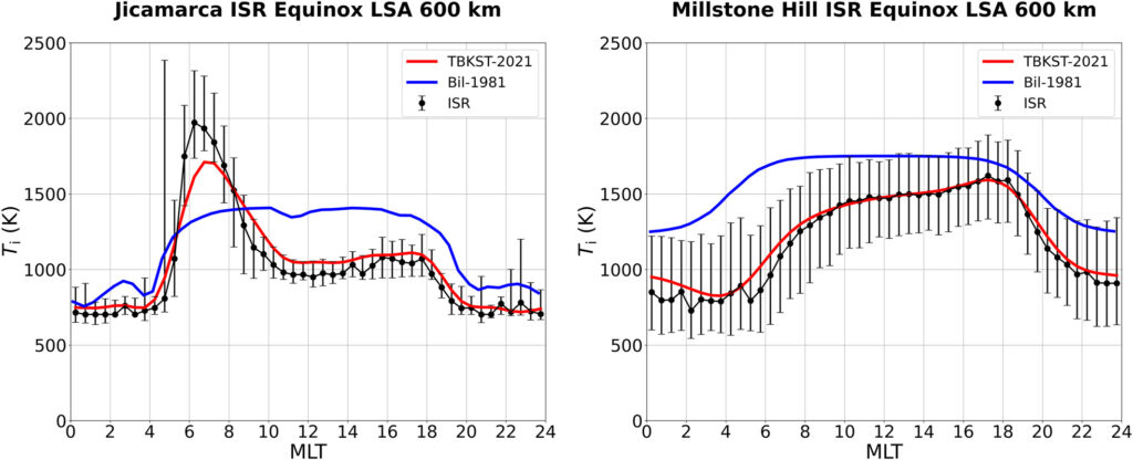
- Incoherent scatter data from the radars at Jicamarca/Peru, Arecibo/Puerto Rico, Millstone Hill/USA, St. Santin/ France, and Malvern/U.K.;
- Compilations of rocket data have helped to model the lowest part of the ionosphere that is too low for satellites; and
- Data from the Global Navigation Satellite Systems using tomographic or radio occultation techniques are one of the newest data source.
What advances in knowledge have been made as a result of the IRI model?
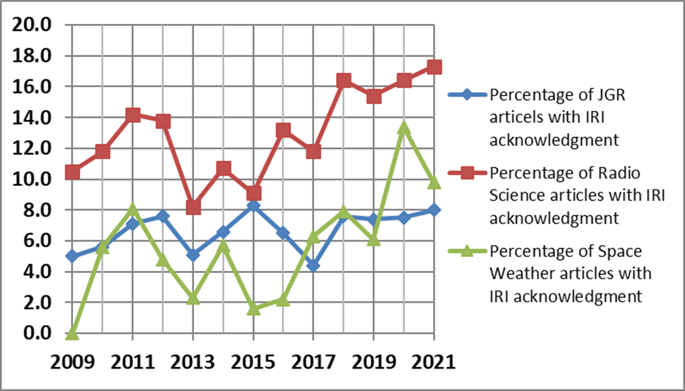
The IRI model has contributed extensively to scientific research in many different areas. This is best documented by the significant percentage of scientific papers that acknowledge the usage of the IRI model across a wide array of journals covering many different disciplines. For example, about 8% of the annual papers published in the Journal of Geophysical Research, the flagship journals of AGU, and about 18% Radio Science.
Being a synthesis of the existing empirical evidence for ionospheric parameters, the IRI model is often the first baseline against which data from a new satellite mission or a new ground-based instrument are compared. The model has helped to improve and refine data analysis techniques like radio occultation and tomographic approaches by serving as background ionosphere for testing these methods.
What are the limitations of the IRI model?
The quality and correctness of IRI predictions depends on the quality and reliability of the databases that were available for its development and how good their global and temporal coverages are. The ionosonde database, for example, has a bias towards Northern mid-latitudes due to the global distribution of ionosondes. This can lead to misrepresentation of hemispheric differences. Satellite data have helped to alleviate this problem to some extent. Recent very low and broad solar minima of the 11-year solar cycle brought conditions not covered by data available from previous solar minima leading to overestimations by the model.
Additionally, IRI, like any empirical model, describes average conditions. In the case of IRI these are monthly averages. A number of different techniques have been used to bring the IRI model closer to real-time conditions including normalizing model profiles with measured key parameters or using assimilative techniques to adopt the background IRI model to the available real-time measurements.
What are some remaining challenges where additional research, data or modeling efforts are needed?
More data and improved modeling efforts are needed at high and low latitudes. At high latitudes a multitude of interactions of the ionospheric plasma with the magnetosphere, radiation belts, and solar wind necessitates a much larger database than we currently have to accurately represent this region in IRI. At low latitudes the almost horizontal magnetic field and an eastward current (electrojet) flowing along the magnetic equator produce a number of irregularities and anomalies that can disrupt satellite-based communication. Here the challenge is to improve or develop new models that describe the occurrence probability of such irregularities (e.g., spread-F, plasma bubbles, scintillation) and investigate the correlation between these different phenomena.
The Global Navigation Satellite Systems measure the total electron content (TEC) between satellite and ground station providing continuous global coverage for this parameter since 1992. Efforts are underway to use these TEC global maps for real-time updating of the IRI model.
—Dieter Bilitza ([email protected];  0000-0001-6551-2929), George Mason University, USA