In January 2020, the Taal volcano in the Philippines erupted for the first time since 1977, spewing steam, tephra, and lava for 10 days. Millions of nearby inhabitants were put at risk from falling ash and poor air quality. Like many of our volcanologist colleagues, we were interviewed by media outlets to provide expertise to the public in the wake of the eruption. The same questions kept popping up: What will happen next? Will the volcano explode? We could provide only one definitive answer: We don’t know!
Such a dead-end answer to a fundamental and seemingly straightforward question highlights our lack of understanding of the complex processes that occur in the volcanic plumbing systems (VPS) under volcanoes.
In the Kitchen
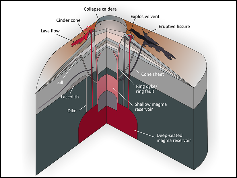
The subterranean environment below an active volcano is a sort of geologic “kitchen” where magmas stall, migrate, and evolve through interlinked chemical, thermal, and mechanical processes. The pans and pots in which these processes take place comprise structures of very diverse shapes and sizes. Such structures include sheet-like intrusions, pipelike conduits, and magma reservoirs. Depicted in drawings like Figure 1, this variety of overlapping and cross-cutting volcanic features may seem intricate, but it is not incomprehensible. However, without labels, color coding, and cutaways to guide us, the reality of plumbing systems below actual volcanoes is far messier [Burchardt and Galland, 2016]. It’s no wonder volcanologists struggle to unravel the complex dynamics of VPS and to predict their behavior.
To clarify the state of the art in our understanding of VPS and to guide future research, 85 scientists from all over the world met in November 2019 in Malargüe in the Mendoza Province of Argentina for the LASI6 workshop. (LASI’s official title is “The Physical Geology of Subvolcanic Systems: Laccoliths, Sills and Dykes.”)
The 2-day scientific meeting preceded a spectacular 3-day field workshop through the geological wonders of the Andes of the Neuquén Basin, where outstanding outcrops of former VPS, now extinct or “frozen,” are exposed thanks to tectonic uplift and the semidesert climate. Discussions during the meeting and field trip about our current understanding of VPS highlighted distinct schools of thought.
Cutting Like a Knife or Pushing Like a Probe?
One key reason for our “we don’t know” response during and after the Taal eruption, among others, has been illuminated by new data and understanding that challenge prevailing scientific assumptions about how magma makes its way upward through layers of solid rock. Does magma form sharp-tipped cracks that stretch surrounding rock until it breaks, as commonly assumed, or does it nudge the rock around it, causing it to flow and deform?

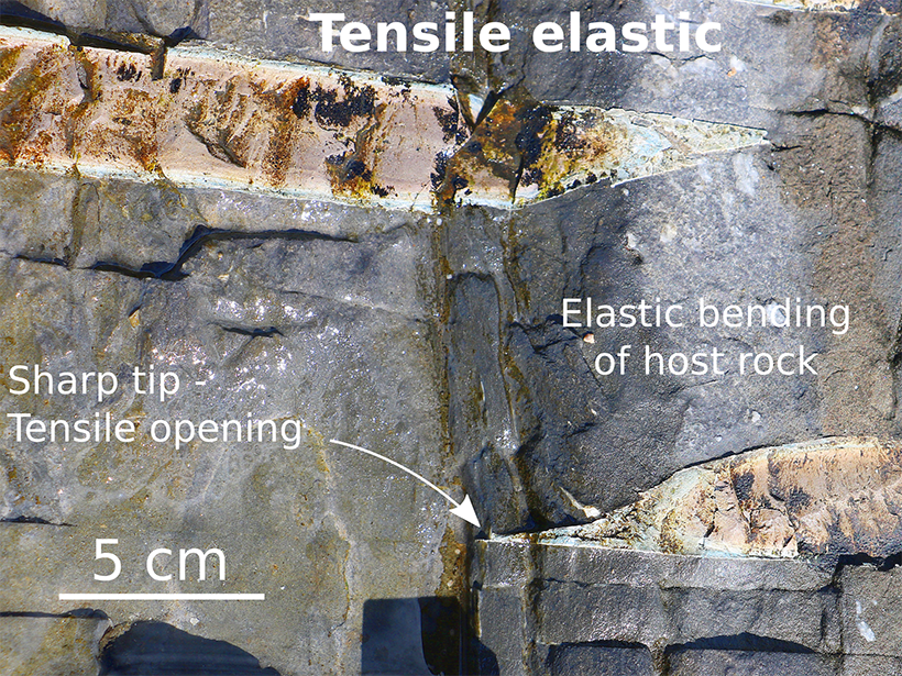
The main magma conduits in the upper crust exhibit sheet shapes, such as subvertical dikes, horizontal sills and thin laccoliths, and inclined cone sheets (Figure 1). Because their shapes resemble fractures, the established theory assumes that these intrusions are like cracks. That is, the tips of the intrusions are pointed, and they propagate by causing the surrounding crustal rock to stretch, bend, and fail in a tensile manner (Figure 2) [Rivalta et al., 2015; Poppe et al., 2020]. This elastic tensile failure theory is the foundation of the most established geodetic models used to analyze ground movements monitored at active volcanoes with interferometric synthetic aperture radar. Elastic tensile failure is also commonly invoked for the interpretation of seismological data associated with dike emplacement.

However, recent field observations presented at the LASI6 meeting called into question the universality of this theory. At some of the localities visited during the field workshop, the tips of well-exposed magma sheet intrusions are rounded and blunt—anything but sharp [Spacapan et al., 2017; Galland et al., 2019]. In addition, the sheet intrusions appeared to have propagated more like an indenter that pushed the host rock ahead. Thus, the host rock dominantly deformed by plastic failure or flow, with accompanying small-scale faulting and folding. The host rock was intensely shortened and squeezed on a local scale, in drastic contradiction to the established elastic theory that assumes the prominence of tension and negligible deformation of the host rock (Figure 3).
Novel laboratory and numerical models also presented at the meeting support these observations, demonstrating that inelastic movement of Earth’s crust (i.e., flowing rather than stretching and snapping) plays a major role in the emplacement of magma pathways in VPS.

These new observations and models could dramatically shift our understanding of the dynamics of magma in VPS. Overall, they show that there are at least two very distinct mechanisms, elastic versus plastic, governing the emplacement of the main magma pathways in VPS and challenging the decades-old notion that all deformation in VPS is elastic.
Revising Our Models
These results have implications for geodetic modeling applied to active volcanic systems. Geodetic models are mathematical tools that calculate deformation of Earth’s surface in response to subsurface geological phenomena. Volcanologists fit geodetic data collected in the field or via satellite monitoring with these models, which are based on our understanding of the physical and mechanical properties and behaviors of rock under different conditions. Common inputs of geodetical models applied in volcanology are the shape and kinematics of a subsurface magmatic pressure source. The best fit then provides information about the shape of the pressure source.
The most common geodetic models consider pressure sources in terms of the elastic dike theory, envisioning dilating crack-like magma intrusions that stretch only the surrounding rock. These models predict the occurrence of two bulges uplifting Earth’s surface, separated by an elongated trough, above the uppermost part of the subsurface dike (see the review by Sigmundsson et al. [2018]).
At the LASI conference, researchers presented results from laboratory geodetic experiments intended to simulate magma emplacement processes. These laboratory-scale models involved injecting a model magma, made of vegetable oil, into a model crust made of compacted dry powders (see the review by Galland et al. [2018]). Contrary to the mathematical model predictions, the results of these experiments show that plastic dikes produce a distinct ground deformation pattern with a single bulge of the surface above the dike apex.
Deciphering whether a signal comes from an ascending dike or a laterally spreading sill is crucial in predicting the eruptive potential of restive volcanic systems.
Current geodetic models, because they are based on rocks exhibiting elastic behavior, are unable to infer from such a single-bulge uplift signal that a dike is propagating upward through the subsurface. Instead, such uplift signals are systematically interpreted as resulting from either a growing horizontal sill or an inflating spherical or ellipsoidal “bubble” of magma. The “magma bubble” interpretation is physically unrealistic in Earth’s brittle crust and has not been observed in the field. Deciphering whether a signal comes from an ascending dike or a laterally spreading sill is crucial in predicting the eruptive potential of restive volcanic systems.
The above case shows the importance of multidisciplinary knowledge and approaches in unraveling the dynamics of active VPS [Burchardt and Galland, 2016]. First, field observations led to questions about the established theory of sheet intrusion emplacement, motivating development of novel mechanical models of magma emplacement. With these models, we found out that the geodetic signals associated with distinct emplacement mechanisms are substantially different from one another and that established geodetic models cannot replicate the geodetic signals induced by plastic dikes.
Collaborating to Clarify Plumbing Systems
A key challenge when studying VPS is to reveal their entire, kilometer-scale structure. In active volcanic areas, VPS are fully buried, and standard geophysical imaging is subject to severe problems with low resolution and detection sensitivity. Meanwhile, outcrops showing parts of extinct VPS are limited in extent, and remaining structures in the subsurface are out of reach. The classic academic approach to studying VPS thus provides incomplete pictures of whole VPS.
Large geophysical data sets characterizing subsurface VPS do exist, largely in the mining and petroleum industry, although companies often keep these data sets to themselves as proprietary information. Numerous mined ore deposits occur amid frozen VPS, one of the most famous examples being the giant Chuquicamata copper mine in northern Chile, which is associated with an upper Eocene–Oligocene granitic porphyry.
Mining exploration is based on systematic, high-density rock coring. This sort of exploration provides invaluable data sets with which to map and reconstruct the complex subsurface 3D structures of VPS that are otherwise unreachable by standard field mapping. Conversely, scientific knowledge gained from the use of industry data sets provides information about the formation of ore deposits that can be applied to improve the efficiency of exploration.
In addition to information gained from mining, the past 2 decades of hydrocarbon exploration have revealed that numerous sedimentary basins worldwide—where petroleum and natural gas deposits are predominantly found—host many ancient, buried VPS. For decades, these systems emplaced in sedimentary basins were considered impediments to hydrocarbon exploration. Recently, however, they have been shown potentially to enhance hydrocarbon maturation (the conversion of raw organic material to hydrocarbons like petroleum), and they can even host hydrocarbon resources [Senger et al., 2017].
For instance, in the Neuquén Basin in Argentina, large hydrocarbon fields are either hosted within fractures in the magmatic rocks of frozen VPS or trapped in structures induced by magmatic conduits [Spacapan et al., 2020]. In the Parnaiba Basin in Brazil, extensive sills act as caprocks for hydrocarbon reservoirs, keeping these reserves from migrating to the surface, where they can weather or dissipate [de Miranda et al., 2018].

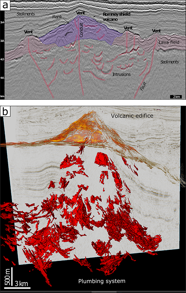
The main tool used in hydrocarbon exploration to observe VPS buried in sedimentary basins is interpretation of 2D and 3D seismic reflection data sets, which allows imaging of kilometer-scale subsurface structures. Because of high contrasts in the way that sound travels through magmatic versus sedimentary rocks, seismic data allow excellent imaging of whole VPS over scales of several tens of kilometers (Figure 4) [Rabbel et al., 2018; Bischoff et al., 2020], overcoming a critical limitation of field-based approaches.
To a large extent, the effects of VPS on hydrocarbon systems remain poorly understood. In some locations, VPS can enhance hydrocarbon maturation, but in others, they overcook and destroy petroleum systems. In some cases, magmatic conduits are permeable pathways for hydrocarbon migration, but in other cases they are permeability barriers. These primary questions for industrial exploration are also highly relevant scientific questions regarding magma emplacement mechanics, magma-sediment interactions, and basin evolution.
Mutual Returns on Investment
Volcanologists have benefited greatly from using mining and hydrocarbon industry data collected at high costs that are beyond most academic budgets. At the same time, academic research contributes expertise and new insights into ore and hydrocarbon exploration and production. (Another obvious industrial application of research on VPS is in developing technologies to produce geothermal energy from active or semiactive volcanic systems.)
The LASI6 meeting highlighted how integrating field observations of exposed frozen VPS, new modeling approaches, and industry data can help considerably in unraveling the complex structures and dynamics of active volcanic plumbing systems. Volcano geophysicists and geodesists must collaborate with field geologists, physicists, and industry to continue improving physical interpretations of geophysical and geodetic data measured in active volcanoes.
Through such efforts, we should emerge with a better understanding of and capability to predict the behavior of hazardous volcanic systems. And perhaps, after future eruptions, when scientists are asked what will happen next, we will have an answer.
Acknowledgments
This article is built on the outcome of the LASI6 meeting (The Physical Geology of Subvolcanic Systems: Laccoliths, Sills and Dykes), held in Malargüe, Argentina, in November 2019. We warmly thank the workshop participants for their constructive contributions, despite the remoteness of the meeting place. The meeting was supported financially by Y-TEC, Fundación Williams, Fondo para la Investigación Científica y Tecnológica, and Consejo Nacional de Investigaciones Científicas y Técnicas. The organization of the meeting greatly benefited from the logistical support of the Asociación Geológica Argentina. We thank A. Bischoff for providing the images in Figure 4. The abstract book is available at the meeting website.
References
Bischoff, A., et al. (2020), Seismic geomorphology, architecture and stratigraphy of volcanoes buried in sedimentary basins, in Volcanoes: Updates in Volcanology, edited by K. Nemeth, IntechOpen, London, in press.
Burchardt, S., and O. Galland (2016), Studying volcanic plumbing systems – Multidisciplinary approaches to a multifaceted problem, in Updates in Volcanology: From Volcano Modelling to Volcano Geology, edited by K. Nemeth, pp. 23–53, InTech, London, https://doi.org/10.5772/63959.
de Miranda, F. S., et al. (2018), Atypical igneous-sedimentary petroleum systems of the Parnaíba Basin, Brazil: Seismic, well logs and cores, Geol. Soc. Spec. Publ., 472, 341, https://doi.org/10.1144/SP472.15.
Galland, O., et al. (2018), Laboratory modelling of volcano plumbing systems: A review, in Physical Geology of Shallow Magmatic Systems: Dykes, Sills and Laccoliths, edited by C. Breitkreuz and S. Rocchi, pp. 147–214, Springer, Berlin, https://doi.org/10.1007/11157_2015_9.
Galland, O., et al. (2019), Structure, emplacement mechanism and magma-flow significance of igneous fingers – Implications for sill emplacement in sedimentary basins, J. Struct. Geol., 124, 120–135, https://doi.org/10.1016/j.jsg.2019.04.013.
Poppe, S., et al. (2020), Structural and geochemical interactions between magma and sedimentary host rock: The Hovedøya case, Oslo Rift, Norway, Geochem. Geophys. Geosyst., 21, e2019GC008685, https://doi.org/10.1029/2019GC008685.
Rabbel, O., et al. (2018), From field analogues to realistic seismic modelling: A case study of an oil-producing andesitic sill complex in the Neuquén Basin, Argentina, J. Geol. Soc., 175, 580–593, https://doi.org/10.1144/jgs2017-116.
Rivalta, E., et al. (2015), A review of mechanical models of dike propagation: Schools of thought, results and future directions, Tectonophysics, 638, 1–42, https://doi.org/10.1016/j.tecto.2014.10.003.
Senger, K., et al. (2017), Effects of igneous intrusions on the petroleum system: A review, First Break, 35, 47–56, https://doi.org/10.3997/1365-2397.2017011.
Sigmundsson, F., et al. (2018), Magma movements in volcanic plumbing systems and their associated ground deformation and seismic patterns, in Volcanic and Igneous Plumbing Systems, edited by S. Burchardt, pp. 285–322, Elsevier, Amsterdam, https://doi.org/10.1016/B978-0-12-809749-6.00011-X.
Spacapan, J. B., et al. (2017), Igneous sill and finger emplacement mechanism in shale-dominated formations: A field study at Cuesta del Chihuido, Neuquén Basin, Argentina, J. Geol. Soc., 174, 422–433, https://doi.org/10.1144/jgs2016-056.
Spacapan, J. B., et al. (2020), Igneous petroleum systems in the Malargüe fold and thrust belt, Río Grande Valley area, Neuquén Basin, Argentina, Mar. Petrol. Geol., 111, 309–331, https://doi.org/10.1016/j.marpetgeo.2019.08.038.
Author Information
Olivier Galland ([email protected]), Njord Center, Physics of Geological Processes, Department of Geosciences, University of Oslo, Norway; Jose Mescua, Consejo Nacional de Investigaciones Científicas y Técnicas, Mendoza, Argentina; Octavio Palma, Y-TEC, La Plata, Argentina; Graciela Marín, Asociación Geológica Argentina, Buenos Aires, Argentina; and Johnny Albino, Choique Turismo Alternativo, Malargüe, Argentina
Citation:
Galland, O.,Mescua, J.,Palma, O.,Marín, G., and Albino, J. (2020), A fresh perspective on intricate volcanic plumbing systems, Eos, 101, https://doi.org/10.1029/2020EO152537. Published on 17 December 2020.
Text © 2020. The authors. CC BY-NC-ND 3.0
Except where otherwise noted, images are subject to copyright. Any reuse without express permission from the copyright owner is prohibited.

