For the past 12 years, scientists of the National Geodetic Survey have been on a mission.
“Worldwide, this has never been done before with this level of accuracy.”
The agency has sent planes to fly over thousands of kilometers of the United States in methodical, grid-like patterns in an effort to recalculate elevations across the entire country. The reference system is based on tiny variations in gravity that will define elevation above sea level at any given point. When completed, it will map elevation down to 2 centimeters in some places.
“Worldwide, this has never been done before with this level of accuracy,” said William Stone, a geodetic adviser at the National Geodetic Survey (NGS).

In the past, land surveyors building dams, assessing flood risk, laying roads, and developing other infrastructure used a patchwork reference system from the 1980s, which relied in large part on static benchmarks scattered around the country. The new reference system, to be released in 2022, will allow surveyors to simply use a global navigation satellite system (GNSS) receiver and the agency’s models to determine elevations. The model will include a time-varying component to take into account land subsidence and uplift.
The upgrade to the nation’s system of elevations will not only save land surveyors valuable time but could bolster emerging technologies that depend on detailed spatial information, like self-driving cars and drones.
Stone and others from the agency will meet with members of the public to discuss the rollout of the new system at the 2019 Geospatial Summit in Silver Spring, Md., on 6–7 May.
Gravity as a Guide
The United States isn’t the first to conduct airborne gravity surveys in an effort to upgrade elevation reference systems. New Zealand completed their own survey in 2017, and Japan is considering doing the same. But the U.S. project is by far the largest in size, including the whole country and its territories.
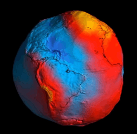
Although we can’t feel the slight changes in gravity in our everyday lives, the acceleration of gravity fluctuates across Earth’s surface depending on the amount of mass present. Near a mountain, the pull of gravity is stronger because of the mountain’s mass, whereas near a valley, the gravitational pull weakens. The change is slight: The pull from gravity might change by a fraction of a percent.
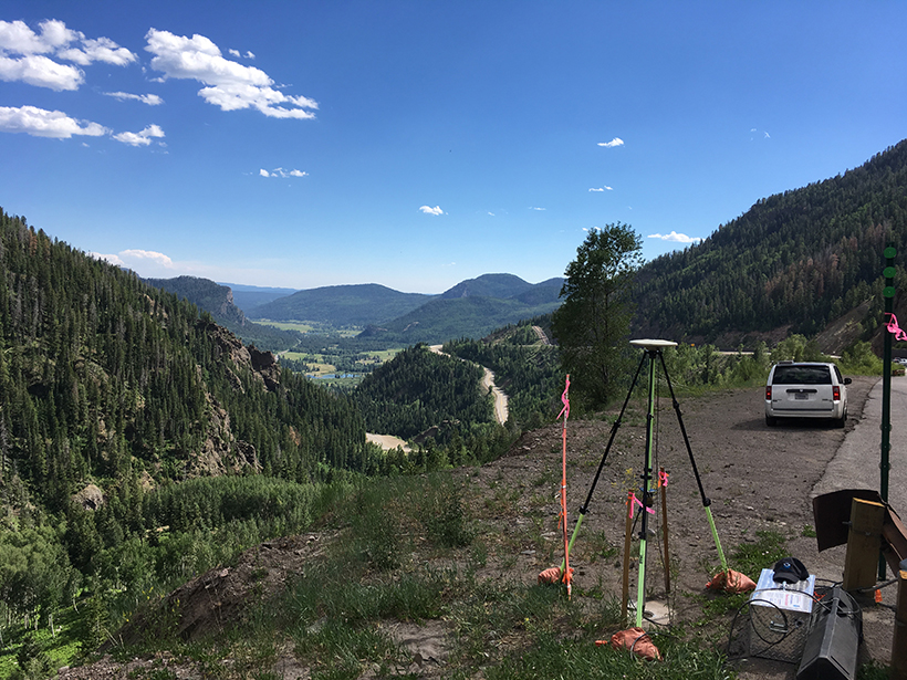
The airborne surveys detect the tiny oscillations in gravity using gravimeters, instruments housed in a series of gimbals and joints to protect them from the plane’s vibrations. The gravimeters contain a weighted rod attached to a spring, which flexes over areas with a stronger pull and relaxes over regions with lower gravity. The airborne survey passed its 75% completed mark in February, and the current operation stretches from South Carolina to Hawaii and American Samoa.
A Modern Geoid
“It’s only recently that we’ve been able to get a good enough measurement of the gravity field to even consider doing this.”
The new elevation system will be based on gravity measured across three spatial scales: NASA’s Gravity Recovery and Climate Experiment (GRACE) and the European Space Agency’s Gravity Field and Steady-State Ocean Circulation Explorer (GOCE) satellites, which record gravity changes from space; the airborne survey; and ground-based stations. Together, the measurements combine to create a picture of the gravity contours, which can be used to trace the position of sea level inward.
“It’s only recently that we’ve been able to get a good enough measurement of the gravity field to even consider doing this,” Vicki Childers, chief of the Observation and Analysis Division at NGS, said. “It’s been kind of the holy grail for a long time.”
The ultimate goal of the project is to create the equipotential geoid, a map of one particular gravity surface stretching from coast to coast. The geoid allows users to simply determine exact elevation from the coordinates of their GNSS devices. Having the geoid as a resource would cut the amount of time cartographers currently spend surveying by 10, according to a report.
The geoid model will include a novel feature that takes into account the slow movement of the ground sinking and rising over time. Earth’s surface is constantly shifting, and the geoid model will factor in those changes. It also offers the model flexibility to include instantaneous changes, like a volcanic eruption or an earthquake.
“Right now, even though we live on a dynamic Earth, our reference system has been stationary,” said NGS scientist Kevin Ahlgren. But with the new model, he said, “when that big earthquake happens, we’re ready to remeasure things afterward and build that into the model.”
Elevations Redefined
The new elevation data will save the United States an estimated $4.8 billion over 15 years from advances in floodplain mapping, emergency planning, storm surge calculations that affect coastal management, and other activities. The gravity survey, called Gravity for the Redefinition of the American Vertical Datum, is budgeted just under $40 million.
Updated elevation data are only one part of the massive undertaking by the National Geodetic Survey to redefine the 3-D reference system in the United States, the National Spatial Reference System, that will go live in 2022. The new system includes not only recalculated elevations but updated latitude and longitude data as well.
Taken together, the new abundance of spatial data could augment automated transportation in the future.
“We’re right on the precipice of self-driving vehicles,” Stone said. Self-driving cars and drones of the future will need extremely accurate 3-D information, according to Stone, as well as a shared reference frame among them. He believes the new NGS reference system could serve as their guide.
“It’s going to revolutionize a lot of applications that aren’t possible today,” Stone said.
—Jenessa Duncombe (@jrdscience), News Writing and Production Intern
Citation:
Duncombe, J. (2019), Airborne gravity surveys are remaking elevations in the U.S., Eos, 100, https://doi.org/10.1029/2019EO122887. Published on 06 May 2019.
Text © 2019. AGU. CC BY-NC-ND 3.0
Except where otherwise noted, images are subject to copyright. Any reuse without express permission from the copyright owner is prohibited.