Clouds remain the largest sources of uncertainty in current climate projections, an observation that was reiterated in the latest reports from the Intergovernmental Panel on Climate Change [2013]. Reducing the uncertainty may require an act of MAGIC.
The Marine ARM GPCI Investigation of Clouds (MAGIC) deployment is a unique field campaign dedicated to observing the stratocumulus-to-cumulus cloud transition over a significantly long period of time to capture the range of variability in the system. GPCI stands for an earlier project called the GCSS Pacific Cross-section Intercomparison, where GCSS is GEWEX Cloud System Studies and GEWEX is the Global Water and Energy Exchanges Project of the World Climate Research Programme. MAGIC is supported and operated by the Atmospheric Radiation Measurement (ARM) Climate Research Facility of the U.S. Department of Energy.
A Shift in Cloud Cover

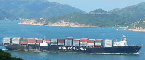
The MAGIC approach took advantage of the mobile nature of the Second ARM Mobile Facility (AMF2) by deploying its suite of marine-capable instruments on board the Horizon Lines cargo container ship Spirit as it plied its regular route between Los Angeles and Honolulu from September 2012 to October 2013. This route transects two cloud regimes that are of great interest to climate modelers, and it lies near a transect previously used to evaluate climate models during the GCPI project [Teixeira et al., 2011]. The clouds are primarily stratocumulus near the coast of California and transition to shallow cumulus clouds, which are the dominant type near Hawaii.
Boundary layer clouds (those within the atmospheric turbulent layer, which is adjacent to the surface and roughly 1 kilometer deep) have a particularly important role in the climate system because of their complex interactions with turbulence, convection, radiation, precipitation, surface fluxes, and large-scale circulation. Stratocumulus clouds, which are often found off the west coast of continents, have high reflectivity (albedo) and large horizontal extent. These clouds transition to a cumulus regime as the boundary layer moves horizontally over warmer waters along the trade winds toward the equator.
Although cumulus clouds play a crucial role in atmospheric vertical transport and in modulating surface evaporation, because of their low areal coverage, their direct interactions with radiation are much less significant for the climate system than those that occur in the stratocumulus regime.
Current climate and weather models fail to reproduce many of the key properties of the stratocumulus-to-cumulus cloud transition.
Because of this remarkable contrast in terms of the interaction with radiation (stratocumulus regimes strongly reflect solar radiation, whereas cumulus regimes do not), the transition from stratocumulus to cumulus is an important element of the climate system. It turns out that this key cloud transition could play an essential role in cloud-climate feedbacks. For example, in a future climate it is conceivable that the characteristics of the stratocumulus and cumulus regimes will remain fairly similar to those in the current climate. On the other hand, the transition between them may be quite different: It may occur farther north or farther south, or it may be more abrupt. A significant change in the location of the transition, for example, would have a tremendous impact on the feedbacks between clouds and climate. However, the physical mechanisms responsible for the transition are not fully understood. In particular, current climate and weather models fail to reproduce many of the key properties of the stratocumulus-to-cumulus cloud transition [e.g., Teixeira et al., 2011].
Models and Satellites Provide a Start
The “purest” version of the stratocumulus-to-cumulus transition is arguably the one that occurs over the eastern North Pacific, as the air flows from California toward Hawaii. At this location, the size of the ocean basin and the shape of the adjacent continents allow for a clear transition between the two cloud regimes.

This specific transition was investigated by Teixeira et al. [2011], who compared a variety of weather and climate models against satellite observations along the GPCI transect, which provides a representative cross section extending from the coast of California southwest to the equator (Figure 1). The study helped characterize the main deficiencies of models in representing this transition but did not allow for a detailed understanding of the physics involved.
Achieving this understanding requires dedicated high-resolution modeling—large-eddy simulation models, for example—and observations of the transition from within the boundary layer. Although some field experiments have been dedicated to studying this cloud transition in the Atlantic [e.g., Bretherton and Pincus, 1995], they were of limited duration—days to weeks.
Some detailed studies have also incorporated observations from field experiments, high-resolution models, and single-column versions of weather and climate models [e.g., Bretherton et al., 1999]. Before MAGIC, however, no long-term field experiment had been dedicated to studying the stratocumulus-to-cumulus transition.
![Fig. 1. False colors show average June-July-August low-level cloud cover from the International Satellite Cloud Climatology Project (ISCCP), with the GPCI transect (solid line) and MAGIC route (dashed line) between Los Angeles and Honolulu marked. Points S6, S11, and S12 used in the Cloud Feedback Model Intercomparison Project (CFMIP)–GCSS Intercomparison of Large-Eddy and Single-Column Models (CGILS) are also shown (based on Figure 1 of Teixeira et al. [2011]).](https://eos.org/wp-content/uploads/2015/06/15-0162_Lewis_4830-figure-1_WEB-480x179.jpg)
Measuring the Clouds
The mobile instrument facility for the MAGIC field study, AMF2, consists of three 20-foot (6.1-meter) cargo containers housing instruments, computers, and supplies. To measure the properties of clouds and precipitation during MAGIC, scientists used three radars, two lidars, two microwave radiometers, a ceilometer to measure the height of the cloud base, a total-sky imager, disdrometers to measure precipitation drop size distribution and velocity, and other instruments.
A suite of instruments measured direct and diffuse incoming solar radiation. Other instrumentation measured key aerosol properties such as concentrations of condensation nuclei, concentrations of cloud condensation nuclei at various relative humidities, aerosol particle size distributions, light scattering and absorption by aerosols at multiple wavelengths, and the extent to which aerosol particles absorb moisture with changing relative humidity.
In addition, scientists collected aerosol samples for later analysis of bulk and individual particle composition, individual particle morphology, and ice-nucleating ability. They also measured basic meteorological quantities and sea surface temperature, enabling computation of surface energy fluxes that can serve as boundary conditions for models attempting to represent processes occurring in the marine boundary layer.
Shipboard researchers launched radiosondes with weather balloons every 6 hours (every 3 hours for the period of 6–18 July 2013) to provide detailed information on atmospheric vertical structure (i.e., temperature, relative humidity, and wind speed and direction). They completed more than 550 successful radiosonde launches.
Clearing Away the Uncertainty
In total, MAGIC completed nearly 20 round trips and 200 days at sea, yielding an unparalleled data set over a region that is vastly undersampled. The data have been ingested and deposited in the ARM data archive, where they are freely available to all.
MAGIC completed nearly 20 round trips and 200 days at sea, yielding an unparalleled data set over a region that is vastly undersampled.
The extent of temporal and spatial sampling within the marine boundary layer as it flows from the cold waters off California to the warmer waters around Hawaii produced an unprecedented observational data set. MAGIC data have the potential to lead to major breakthroughs in our understanding of the physics of the stratocumulus-to-cumulus cloud transition and to the accurate representation of this essential transition in future weather and climate models.
For more information on MAGIC, contact Ernie Lewis or visit the MAGIC website.
Acknowledgments
We thank Horizon Lines and the captain and crew of the Spirit for their support and hospitality during MAGIC. E.R.L. was supported by the U.S. Department of Energy’s Atmospheric System Research Program (Office of Science, OBER) under contract DE-SC00112704. Part of this research was carried out at the Jet Propulsion Laboratory, California Institute of Technology, under a contract with NASA.
References
Bretherton, C. S., and R. Pincus (1995), Cloudiness and marine boundary layer dynamics in the ASTEX Lagrangian experiments. Part I: Synoptic setting and vertical structure, J. Atmos. Sci., 52, 2707–2723.
Bretherton, C. S., S. K. Krueger, M. C. Wyant, P. Bechtold, E. van Meijgaard, B. Stevens, and J. Teixeira (1999), A GCSS boundary-layer cloud model intercomparison of the first ASTEX Lagrangian experiment, Boundary Layer Meteorol., 93, 341–380.
Intergovernmental Panel on Climate Change (2013), Summary for policymakers, in Climate Change 2013: The Physical Science Basis. Contribution of Working Group I to the Fifth Assessment Report of the Intergovernmental Panel on Climate Change, edited by T. F. Stocker et al., pp. 572–595, Cambridge Univ. Press, Cambridge, U. K.
Teixeira, J., et al. (2011), Tropical and sub-tropical cloud transitions in weather and climate prediction models: The GCSS/WGNE Pacific Cross-section Intercomparison (GPCI), J. Clim., 24, 5223–5256, doi:10.1175/2011JCLI3672.1.
Author Information
Ernie R. Lewis, Brookhaven National Laboratory, Upton, N. Y.; email: [email protected]; and João Teixeira, Jet Propulsion Laboratory, California Institute of Technology, Pasadena
Citation: Lewis, Ernie R., and J. Teixeira (2015), Dispelling clouds of uncertainty, Eos, 96, doi:10.1029/2015EO031303. Published on 15 June 2015.
Text © 2015. The authors. CC BY-NC 3.0
Except where otherwise noted, images are subject to copyright. Any reuse without express permission from the copyright owner is prohibited.

