
The Republic of Georgia and the neighboring Russian-occupied region of Abkhazia depend on the energy supplied by the Enguri hydroelectric plant. This plant not only straddles a contentious political border but also sits atop a seismically active region.
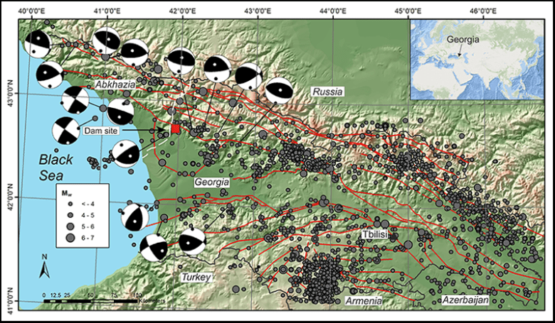
The hydroelectric power station lies in Abkhazia, a region that declared its independence from Georgia in 1999 (although Georgia treats it as an occupied territory of Russia). However, the water power comes from the 271.5-meter Enguri Dam, one of the world’s tallest arch dams, located in Georgia (Figure 1). The 15-kilometer-long artificial water reservoir behind the dam is nestled among the southwestern mountains of the Caucasus, a mountain range that has experienced earthquakes with moment magnitudes (Mw) as strong as 7 [Triep et al., 1995].
The eastern slopes of the Enguri artificial reservoir could be prone to earthquake-induced landslides. Such landslides could cause the Enguri hydroelectric plant to fail or be impaired temporarily, interrupting the energy supply and productive activities and possibly causing social tensions on both sides of the border. Landslide deposits could partially fill the reservoir and decrease the capacity of the dam in the long term. However, these hazards and their probabilities are not well defined, nor is there any system in place to warn nearby residents if a landslide is about to occur.
To improve understanding of the geological hazards affecting this important energy infrastructure and to provide mitigation measures that might help to prevent geopolitical problems in the area, a group of researchers recently embarked on a major collaborative research program under the aegis of the North Atlantic Treaty Organization’s (NATO) Science for Peace and Security program. These researchers came from Italy, the United States, the United Kingdom, Switzerland, Georgia, Azerbaijan, and Kazakhstan.
Scope of the Project

Despite the steep slopes and the potential for earthquake-induced landslides around the reservoir, no one has conducted a quantitative assessment of landslide hazard under seismic conditions here [Gabrichidze, 2013]. One such hazard, the active Khoko landslide (11 million to 21 million cubic meters), which is slowly creeping downslope, lies only a few kilometers from the dam and directly faces the reservoir.
A landslide collapse into the lake would have dramatic consequences: an arrest in energy production or, in the worst-case scenario, dam overtopping by a landslide-triggered tsunami. Either event would have consequences for people in surrounding regions.
What’s more, these events might provoke repercussions for the political stability of the region. The latest war between Georgia and Abkhazia, which claimed 30,000 lives, ended in 1998, and the geopolitical situation has remained unsettled ever since.
The 2015–2018 NATO initiative has a series of major goals: improving the knowledge about the seismicity of the area surrounding the dam, quantifying the landslide hazard under static and dynamic conditions (without seismicity and under seismic shaking, respectively), and identifying factors that might cause a tsunami to propagate in the artificial lake and flood the region below the dam.
The project also aims to train local young researchers to carry out similar studies autonomously in the future. Another goal is to involve end users, such as the hydroelectric company that runs the dam and the Georgia Ministry of Regional Development and Infrastructures, and encourage them to implement monitoring schemes and possible mitigation measures.
A Seismically Active Region
The Enguri hydroelectric facility, with its steep reservoir slopes, is located along one of the most tectonically active areas of the world: the foothills of the Caucasus.
The Enguri hydroelectric facility, with its steep reservoir slopes, is located along one of the most tectonically active areas of the world: the foothills of the Caucasus [Tan and Taymaz, 2006]. Earthquake occurrences in regions with the steep slopes greatly increase the likelihood that landslides will occur. Ground shaking alone can trigger landslides, but it can also decrease the density of soil materials, allowing water to penetrate the ground rapidly and reducing the slope’s stability [Keefer, 1994].
This region is crossed by active faults that can be as long as several tens of kilometers, which strike mostly parallel to the mountain range (Figure 1). Philip et al. [1989] pointed out that the western Greater Caucasus has concentrated deformation at its southern slope, whereas the northern flank is almost undeformed.
This suggests that the push of plate tectonic forces, which produces mountain uplift and shortening across the western Greater Caucasus, is absorbed along the southern border where the Enguri Dam is located. Reilinger et al. [2006] concluded that movement along the Main Caucasus Thrust, located at the southern foothills, is one of the predominant processes accommodating Arabia-Eurasia convergence. In fact, analysis of historical and instrumental seismological data from Georgia indicates past earthquakes as strong as Mw = 6.9 and with a macroseismic intensity of 9 on the Medvedev-Sponheuer-Karnik (MSK) scale.
The most recent seismic hazard zonation of Georgia indicates possible earthquake ground shaking with a peak ground acceleration of 0.3–0.5 g (gravitational units) [Chelidze et al., 2002]. Although the hazard assessment identifies two faults passing near the Enguri Dam that could produce earthquakes of as strong as Mw = 6–7, the expected peak ground acceleration appears underestimated in light of more recent results suggesting 0.65–0.69 g [Tsereteli et al., 2014].
This possible underestimation suggests the need for a careful reassessment by incorporating new investigations of ancient earthquakes. Such investigations will be a major future effort of this project.
Field Surveys Characterize Local Geology

We conducted initial field work within this NATO collaboration in November 2015 and May 2016. All the teams focused their efforts on collecting multidisciplinary data on the various aspects of geohazards. Field surveys integrated with interpretation of high-resolution satellite images allowed us to identify slopes that are actively moving, although slowly, and that in the future might accelerate their movements, producing a landslide failure. In fact, we recognized additional slope movements near the known Khoko landslide (Figure 2). The main road that winds up into the Caucasus requires continuous restoration because of deformation induced by slope movements.
Future large earthquakes in the area might trigger a sudden collapse of these already moving slopes and might also cause failures to develop on other slopes. To assess this possibility and identify the areas most susceptible to slope instability and failure, the international teams started to collect data on the mechanical properties of the rocks and samples. Determining these properties helps risk assessors conduct geotechnical tests as well as morphostructural and geological surveys all along the slopes surrounding the dam and the water reservoir.
Our preliminary results indicate that most of these unstable slopes are highly mobile, on the order of 5–10 centimeters per year.
Our preliminary results indicate that most of these unstable slopes are highly mobile, on the order of 5–10 centimeters per year. Moreover, the whole area of active creeping (Figure 2b) corresponds to an estimated volume of 52 ± 17 million cubic meters. Researchers have also started conducting the first large-scale systematic survey of a wide area surrounding the Enguri Dam to recognize geological-geomorphological evidence of prehistoric surface fault ruptures. The region around the dam shows evidence of recent tectonics, including broad uplift of topography, fault scarps, and folds.
Overdeepened or migrated rivers and the widespread presence of fluvial deposits that date from late Miocene times to the present give evidence of vertical tectonic motions. This succession of sedimentary deposits can be interpreted as evidence of major uplift of this part of the Caucasus with consequent erosion, consistent with previous thermochronometric studies [Vincent et al., 2011]. The fluvial deposits now lie as high as about 150 meters above the surrounding valley floor, and the Enguri River is excavating its own deposits.
In addition, the oldest portion of this continental succession also shows evidence of tectonic folding, whereas locally, we found fault scarps affecting the more recent Plio-Quaternary deposits. These data again attest to recent uplift as well as ongoing seismic deformation of this entire area.
High Landslide Hazard
The first outcomes from this project show that a series of actively moving slopes shapes the eastern flank of the Enguri artificial reservoir and suggest that this region should be considered an area prone to earthquake-triggered slope instability. The presence of historical and instrumental seismicity clearly suggests that some segments of the faults near the Enguri Dam are active. The seismic focal mechanism solutions highlight that these faults have reverse slip motions (Figure 1). These fault motions, together with the presence of uplifted fluvial deposits, the entrenching of the rivers, and the folding of the strata, indicate active tectonic compression.
In this perspective, several reverse faults in the region are potential candidates to trigger earthquakes in the future. The presence of folds and uplifted deposits may also suggest the presence of blind seismogenic faults, that is, earthquake-producing faults that do not break through to the surface.
Toward Early Warning
Ultimately, we seek to forecast disasters better and possibly even prevent some natural catastrophes.
In view of the high mobility and volume of actively sliding areas, the project coordinating committee agreed that we needed to install a series of digital extensometers, which measure changes in length, at the major unstable slope sites. These instruments, together with 14 benchmarks and related GPS measurements, will be used to monitor, in real time and in great detail, slope movements and road deformation. Such instruments will enable us to assess the evolution of the landslide with respect to climate conditions and eventual future earthquakes. Detecting an increase in slope movements might lead to precautionary alerts.
None of the existing studies on these unstable slopes is aimed at assessing their present-day mobility and their possible behavior in the case of earthquake shaking under various meteorological conditions, so our hope is to fill this gap. Ultimately, we seek to forecast disasters better and possibly even prevent some natural catastrophes using a quantitative evaluation of the static and dynamic behavior of these landslides under various possible scenarios. We plan to improve on these assessments by analyzing other instability-prone slopes along the reservoir and their infrastructures.
Cooperation Toward Averting a Disaster
The continued operation of the Enguri Dam may represent a major source of confidence building between Georgia and Abkhazia [Bruch et al., 2009]. Thus, our efforts are currently devoted to planning an early-warning system to help ensure the protection of this dam.
In politically and seismically unstable regions, efforts to protect critical infrastructure could be the solid ground from which to build a more lasting peace.
We also seek to involve local and regional authorities and end users during the entire research process. We expect that the project’s collaboration with Azeri and Kazakh scientists will have a positive impact on international stability because it increases cooperation with neighboring Georgia and with NATO countries. Moreover, since the Caucasus foothills in Georgia and Azerbaijan share the same tectonically active structures, an improvement in the knowledge of the faults along these zones would facilitate seismic hazard and risk assessment in both countries.
In politically and seismically unstable regions, efforts to protect critical infrastructure could be the solid ground from which to build a more lasting peace. Our project will continue to shore up this solid ground.
Acknowledgments
We acknowledge the useful comments of Brian Collins and an anonymous reviewer on a previous version of the manuscript. This is a contribution to the NATO SfP project G4934.
References
Bruch, C., et al. (2009), Post-conflict peace building and natural resources, Yearb. Int. Environ. Law, 19(1), 58–96.
Chelidze, T., et al. (2002), Seismic hazard assessment of Georgia (probabilistic approach), Caucasus Environmental NGO Network (CENN), Tbilisi, Georgia, http://drm.cenn.org/Hazard_assessment_files/eng/Seismic_hazard_assessment_of_Georgia.pdf.
Gabrichidze, G. (2013), 35 Years of the Enguri Arch Dam, Bull. Georgian Natl. Acad. Sci., 7(1), 55–58.
Keefer, D. K. (1994), The importance of earthquake-induced landslides to long-term slope erosion and slope-failure hazards in seismically active regions, Geomorphology, 10(1–4), 265–284.
Philip, H., et al. (1989), The Caucasus: An actual example of the initial stages of continental collision, Tectonophysics, 161(1), 1–21.
Reilinger, R., et al. (2006), GPS constraints on continental deformation in the Africa-Arabia-Eurasia continental collision zone and implications for the dynamics of plate interactions, J. Geophys. Res., 111, B05411, doi:10.1029/2005JB004051.
Tan, O., and T. Taymaz (2006), Active tectonics of the Caucasus: Earthquake source mechanisms and rupture histories obtained from inversion of teleseismic body waveforms, Spec. Pap. Geol. Soc. Am., 409, 531–578.
Triep, E. G., et al. (1995), Active thrust front of the Greater Caucasus: The April 29, 1991, Racha earthquake sequence and its tectonic implications, J. Geophys. Res., 100(B3), 4011–4033.
Tsereteli, N., et al. (2014), Vulnerability analysis and GIS based seismic risk assessment Georgia case, in Improving Disaster Resilience and Mitigation—IT Means and Tools, Springer, Dordrecht, Netherlands.
Vincent, S. J., et al. (2011), The exhumation of the western Greater Caucasus: A thermochronometric study, Geol. Mag., 148(1), 1–21.
Author Information
Alessandro Tibaldi (email: alessandro.tibaldi@unimib.it), Department of Earth and Environmental Sciences, University of Milano-Bicocca, Milan, Italy; and Nino Tsereteli, M. Nodia Institute of Geophysics, M. Javakhishvili Tbilisi State University, Tbilisi, Georgia
Citation:
Tibaldi, A.,Tsereteli, N. (2017), International effort tackles landslide hazards to keep the peace, Eos, 98, https://doi.org/10.1029/2017EO065815. Published on 30 January 2017.
Text © 2017. The authors. CC BY-NC-ND 3.0
Except where otherwise noted, images are subject to copyright. Any reuse without express permission from the copyright owner is prohibited.