Landslides are one of the costliest and deadliest natural phenomena in mountainous regions. Between 2007 and 2015, 7000 rainfall-triggered landslides around the world killed more than 25,000 according to NASA’s Global Landslide Catalog. The U.S. Geological survey estimates that costs from these events could reach $4 billion or more each year.
Landslides are also one of the most difficult natural disasters to predict because the factors that affect slope stability vary dramatically in both space and time. However, dramatic advances in precipitation estimation, high-resolution imagery, and elevation maps are advancing our ability to predict the threat of rainfall-triggered landslides in real time. Applying these advances to landslide prediction, especially in developing areas of the world, could save countless lives and direct resources to where they are most needed for landslide prevention and recovery.
To help with efforts to develop a prototype for landslide prediction, the Hydrologic Research Center (HRC), a nonprofit research corporation, set out to develop a landslide hazard threat assessment for Central America. We focused on the nations of Central America because of the strong regional partnerships already in place there, as well as the availability of relevant data.
Our approach involves including landslide threats in flash flood guidance threat assessments. We got our first opportunity to validate our threat assessment system in October 2015, when a major landslide occurred in an area of Guatemala that we had flagged as an area of very high risk during that time period.
Aims of the Assessment
Predicting the threat of rain-induced landslides is imperative. A recent review shows that 90% of all recorded landslides in Latin America and the Caribbean were triggered by heavy rainfall, which increases the amount of moisture in the soil [Sepulveda and Petley, 2015]. This review found that between 2004 and 2013, about 2730 people died in 128 landslides in Central America. Of the landslides that were triggered by rainfall, 15% were associated with named tropical storm events. Only 4% of landslides were earthquake induced, and the remaining 6% were associated with construction or volcanic activity.
To help mitigate this high level of risk, our assessment has three main goals:
- develop a calibrated and validated spatial and temporal representation of real-time landslide hazard threat assessments for regional emergency management services
- train national meteorological and hydrologic services in how to understand and interpret landslide hazard threat assessment products
- bring partners together to discuss landslide issues and identify opportunities where we can develop such tools as planning, education, and warning systems to reduce the impact of landslide events
Central American Regional Partnerships
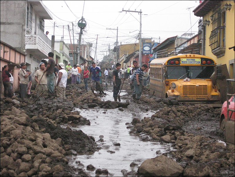
Landslide threat assessments across Central America accelerated after October 1998, when Hurricane Mitch dropped record-breaking amounts of rain on Honduras, Guatemala, and Nicaragua—more than 900 millimeters in some regions of Honduras. The resulting floods made Mitch the second deadliest Atlantic hurricane in history, with nearly 11,000 fatalities and a similar number of people reported missing. The U.S. Army Corps of Engineers estimated that the landslides that followed damaged 70% of the road network in Honduras, and a conservative estimate by the U.S. Geological Survey (USGS) places the number of Honduran landslide fatalities at nearly 1000.
The landslides that followed Hurricane Mitch damaged 70% of the road network in Honduras and killed nearly 1000 people.
The USGS produced a detailed report of landslides in the affected areas, as well as a discussion of these landslides. A subsequent effort, led by the Norwegian Geotechnical Institute, organized annual landslide workshops from 2003 to 2008. These workshops focused on training national hydrologic and meteorological services and disaster management agencies to inventory landslides, map hazards, and assess threats. Recently, the Japan International Cooperation Agency began working in Honduras to help develop landslide hazard threat assessments.
The Science of Assessing Landslide Hazard Threats
Predicting the temporal and spatial occurrence of rainfall-triggered shallow landslides represents an important scientific and practical issue. Intrinsic factors (topography, geology, soil, and engineering properties) and extrinsic factors (rainfall, land cover, fire, glacier outbursts, earthquakes, and volcanoes) control slope stability and landslide triggering. The likelihood of a landslide is also affected by the nonuniform nature of the structural forces that hold a slope together and the physical mechanisms that trigger the landslide.
Landslide hazard threat assessments are segregated in both space and time—each assessment is separate unto itself. Spatial threat assessments (susceptibility maps) are derived in one of two ways: using spatially distributed parameters (e.g., slope, geology, precipitation totals) to assign a weight to individual pixels in a grid or using a database of existing landslides, along with spatially distributed parameters, to derive weights using a variety of statistical methods.
Wanted: Protocols for Tracking Landslides
Although using a database of known landslide events is ideal, potential biases in existing landslide databases pose severe limitations. For example, some databases account only for landslides that affect human life, property, or infrastructure. The lack of a common data collection protocol (size, depth, runout length, etc.) means that various databases record different accounts of the same landslide. Therefore, developing protocols for these landslide databases is critical for efforts in understanding landslide distribution and associations with landscape characteristics.
During our communications with other national meteorological and hydrologic services and emergency management agencies from all over Central America, this need became starkly clear: Most systems had no well-defined protocol for landslide data collection.
For example, we learned that El Salvador’s Ministry of Natural Resources and the Environment has a detailed database of landslides that includes event timing and site visit reports. We verified the landslides using online imagery and a review of the site visit reports. Events were often recorded as locations where populations were affected, rather than the landslide source (Figure 1). We performed a thorough quality control assessment of the database (Figure 2) that highlighted the need for the development of a systematic data collection and storage protocol.

So we’re tackling these needs: Current project goals include developing the required data collection protocols and storage, familiarizing partners with the flash flood guidance system, and introducing the new landslide hazard threat assessment.

Rainfall and Soil Moisture Add Complexity
Even if we do have a detailed database, identifying slopes with high landslide threat levels is difficult, and predicting when rainfall-triggered landslides will occur is even more difficult and fraught with uncertainty. At the hillslope scale, a variety of tools are available, including sophisticated monitoring systems and high-resolution modeling, which are infeasible at the regional scale.
In lieu of monitoring each landslide-prone location, regional real-time landslide hazard threat assessments generally rely exclusively on rainfall thresholds. These hazard assessments most commonly use precipitation conditions observed during a sample of landslide events to construct a precipitation intensity–duration curve.
This method has been adapted and used in many regions; however, in most cases landslide hazard threat assessments based solely on precipitation intensity and duration are insufficient because soil moisture conditions play a crucial role. We do not recommend using estimates of precipitation that precedes a landslide in place of soil wetness conditions; the nonuniformity of geophysical and climatic characteristics weakens the correlation between antecedent precipitation and actual soil moisture observations [Baum and Godt, 2009].
Soil moisture estimates can be achieved through in situ measurement, remote sensing, and hydrologic model simulations. When all these sources are available, their integration may provide reliable estimates of soil moisture at the scales required for landslide hazard threat assessment operational warning systems. However, few locations maintain sustained in situ soil moisture measurements. Remote sensing of soil moisture has come a long way, but serious limitations remain, particularly in mountainous regions with dense vegetation.
Therefore, in most cases, real-time soil moisture levels can most readily be estimated using hydrologic model simulations. This is the approach we use.
Including a Landslide Hazard Assessment in Flash Flood Guidance Systems
In recent years, regional operational flash flood guidance systems have been implemented worldwide. These systems use real-time remotely sensed data to estimate precipitation over regional scales at a high resolution (4 kilometers × 4 kilometers).
The HRC has invested more than a decade in the development of their flash flood guidance systems [Georgakakos et al., 2013]. National meteorological and hydrologic services use the system across Central America to predict flash flooding.
The HRC team has a new push: incorporate a landslide hazard threat assessment into our flash flood guidance systems.
As a result of conversations with national meteorological and hydrologic services and emergency management systems, the HRC team has a new push: incorporate a landslide hazard threat assessment into our flash flood guidance systems. To do this, HRC systems merge precipitation data from several satellites, radars, and rain gauges and then use them as inputs in a high-resolution model that accounts for soil moisture.
These simulations produce estimates of soil water deficit levels in various soil zones and estimate the propensity of small basins (about 160 square kilometers) for flash flooding [Georgakakos et al., 2013]. These operational regional systems provide hourly estimates of depth-integrated soil moisture for two layers in the soil for each small basin.
Assessments Based on Observation
Our project introduces a novel approach for landslide hazard threat assessment at the regional scale using a phenomenological model. In other words, the model is based on observations rather than derived from theory.
The approach is suitable for use in conjunction with the operational flash flood guidance systems and with landslide susceptibility mapping [Posner and Georgakakos, 2015a, 2015b]. The landslide susceptibility mapping helps us locate where landslides are most likely to occur, and the flash flood guidance system helps predict the timing of these landslides [Posner and Georgakakos, 2015a]. We can conduct real-time assessment of the probability that a landslide will occur through a paired precipitation and soil moisture threshold for individual small basins [Posner and Georgakakos, 2015b].
Does the Assessment Work?
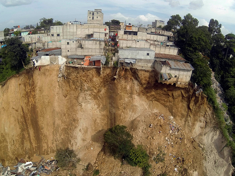
Initial findings are encouraging—both the static susceptibility map and the real-time landslide hazard threat assessment identified El Cambray as having the highest possible threat levels.
On 1 October 2015, we got our first opportunity to validate the system after its development. Heavy rains triggered a landslide in the community of El Cambray, Guatemala, killing at least 280 people and leaving some parts of the village under 15 meters of earth and debris.
Initial findings are encouraging—both the static susceptibility map and the real-time landslide hazard threat assessment identified El Cambray as having the highest possible threat levels. As more events occur and as regional partners continue to complete their own countries’ landslide inventories, we will update the HRC landslide hazard threat assessment model parameters to reflect the most complete and accurate landslide threat assessment.
References
Baum, R. L., and J. W. Godt (2009), Early warning of rainfall-induced shallow landslides and debris flows in the USA, Landslides, 7(3), 259–272
Georgakakos, K. P., R. Graham, R. Jubach, T. M. Modrick, E. Shamir, and J. A. Sperfslage (2013), Global flash flood guidance system, phase I, HRC Tech. Rep. 9, 134 pp., Hydrol. Res. Cent., San Diego, Calif.
Posner, A. J., and K. P. Georgakakos (2015a), Normalized landslide index method for susceptibility map development in El Salvador, Nat. Hazards, 79(3), 1825–1845.
Posner, A. J., and K. P. Georgakakos (2015b), Soil moisture and precipitation thresholds for real-time landslide prediction in El Salvador, Landslides, 12(6), 1179–1196.
Sepulveda, S. A., and D. N. Petley (2015), Regional trends and controlling factors of fatal landslides in Latin America and the Caribbean, Nat. Hazards Earth Syst. Sci., 15, 1821–1833.
Author Information
Ari J. Posner (email: [email protected]), River Analysis Group, U.S. Bureau of Reclamation, Albuquerque, N.M.; and Konstantine P. Georgakakos, Hydrologic Research Center, San Diego, Calif.
Citation:
Posner, A. J.,Georgakakos, K. P. (2016), An early warning system for landslide danger, Eos, 97, https://doi.org/10.1029/2016EO062323. Published on 03 November 2016.
Text © 2016. The authors. CC BY-NC-ND 3.0
Except where otherwise noted, images are subject to copyright. Any reuse without express permission from the copyright owner is prohibited.