Mountain communities face a daunting future: Since the 1970s, the warming globe has melted thousands of mountain glaciers from the Andes to the Himalayas, leaving behind hundreds of massive, unstable lakes that can be knocked loose by an earthquake, rockfall, or avalanche. As the Earth continues to warm, the risk only grows for the more than 100,000 people who live downstream of these lakes.
More than 100,000 people live downstream of these lakes.
Despite efforts to study these lakes and characterize the hazards they pose, many living nearby remain unaware of the dangers they face. This is because “local communities in general have been pretty much ignored by the research community through the decades,” said Alton Byers, a mountain geographer and director of science and exploration at The Mountain Institute, a nonprofit organization that works to conserve mountain environments and communities.
Overlooking those who live closest to glacial lakes can stymie hazard mitigation, Byers explained. Government organizations like the U.S. Agency for International Development (USAID) are now taking notice and providing funds for scientists to better explain hazards to communities around mountain glaciers.
Flooding Hazards: Peru and Nepal

Glacial lakes form at the feet of melting, retreating glaciers in depressions left over by glacial scour. These depressions fill up with meltwater—some, like Nepal’s Imja Lake, can hold as much water as 26,000 Olympic-sized swimming pools.
Melted glaciers also leave behind huge, unstable piles of rock and debris called moraines, which often are the only barriers between lake water and a bustling town below. Should the side of a mountain suddenly collapse, snow or rock could careen into the lake, forming a tsunami-like wave that can surge over the top of the moraine. If the moraine were to fail, residents below would face two floods, one after the other. In addition, the moraine itself could be cemented together with ice, which also could melt and destabilize it.
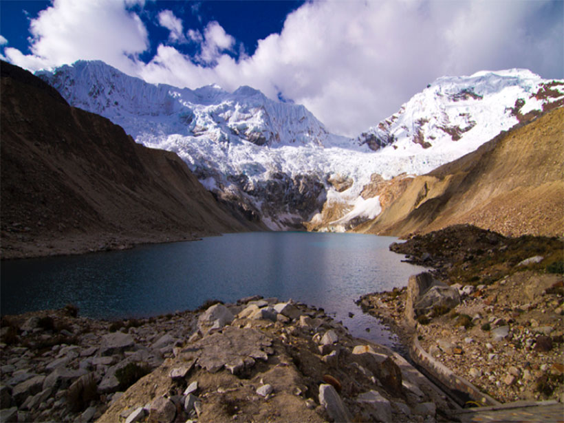
In Peru, hundreds of glacial lakes dot the Andes, and thousands of people have been killed by glacial outburst floods (GLOFs). In 1941 a GLOF from Lake Palcacocha, a large glacial lake that sits 4567 meters high in Peru’s Cordillera Blanca mountain range and looms over the city of Huaraz, killed 5000 people. Over the next decade, two more floods killed another thousand.
The lake is now 34 times larger, holding more than 17 million cubic meters of water (that’s about 6800 Olympic swimming pools). About 100,000 people live in Huaraz today.
In the Hindu Kush and Himalayas, more than 200 lakes pose a flood hazard, according to the United Nations Office for the Coordination of Humanitarian Affairs. For example, Imja Lake started growing in the 1960s and is considered one of the fastest growing lakes in the Himalayas. It contains 75 million cubic meters of water, and its length grows at a pace of 75 meters per year. Although overhanging rocks and snow currently don’t threaten to collapse into the lake and cause waters to overtop its moraine, its volume of water designates it as one of the more dangerous lakes in the world, Byers said.

Hazard Disconnect
Daene McKinney, an environmental and water resources engineer at the University of Texas at Austin, who helps build early warning systems at glacial lakes in Nepal and Peru, said that when local communities aren’t involved in the installation of these expensive and complicated systems, problems arise.
In 2000, for example, scientists and engineers set up an early warning system at Tsho Rolpa, another lake in Nepal. Tsho Rolpa holds nearly 100 million cubic meters of water and is situated 4580 meters high in the mountains, upstream of several towns and villages, McKinney said. Its warming system is one of only four in the world that he’s aware of.
When local communities aren’t involved in the installation of these expensive and complicated systems, problems arise.
The systems use many different kinds of instruments to detect a cascade of events. Seismic instruments detect the rumblings of a rockfall or avalanche. Lasers are placed at a height such that waves big enough to release a flood interrupt their beams. Other height detection instruments determine whether the wave is likely to overtop the moraine at the end of the lake.
Today, communities downstream of Tsho Rolpa know how to respond to an alarm signaling an oncoming flood. Originally, however, they weren’t involved and were never educated about how the system worked, McKinney said, and “by 2010 the system was inoperable because of lack of maintenance and vandalism.” However, following the magnitude 7.8 earthquake that shook Nepal on 25 April 2015, officials installed a new warning system, which will trigger sirens and send notifications to mobile phones should a flood be imminent.
The Human Side
Research on GLOFs historically focused only on the physical aspects of glacial lakes and floods—moraine stability, bedrock conditions, glacier shrinkage, climate conditions, etc. Although such studies are important, it’s also important to include the populations who live around the glacier, said Mark Carey, a science historian who focuses on glaciers at the University of Oregon in Eugene.

Carey studies the human side of glaciers, specifically, how people of different races, ethnicities, classes—and, more recently, genders—experience glaciers and react to such hazards as GLOFs. He also explores how these differences fit into the larger issue of climate change’s effects on mountain glaciers.
“If we define [GLOFs] solely as an environmental problem, we miss all those people,” Carey said. Moraine assessments, glacial dynamics—“none of these topics are related to the vulnerability of human communities.”
Because funding in the United States is mostly “devoted to the natural sciences compared to the social sciences and humanities,” Carey said, “we end up with fewer studies on how people perceive and respond to hazards, why they live in hazard zones to begin with, [and] how race and class and gender divisions might endanger some populations more than others.”
Carey recommends that the glaciologists embrace traditionally overlooked voices—women, who may have to take care of households and not have access to jobs, and those most impoverished, who might not wield as much political power.
Connecting with Communities
Organizations like USAID are driving this change in approach, giving funds for researchers like Carey, Byers, and McKinney to work with local people in Peru and Nepal to help communicate GLOF dangers and the science.
As seen in the video below, outreach efforts include connecting communities across the globe who face similar hazards and taking local leaders to less remote lakes to highlight the dangers they face.
A critically important aspect of this education is trust. A scientist “needs to gain the trust of communities by being responsive to their needs and priorities,” said Jorge Recharte, director of The Mountain Institute’s Andes program, who works with local mountain communities in the Andes who live near glacial lakes. Building trust can be difficult, he added—only recently have local governments started to provide funding and resources for groups like The Mountain Institute for more outreach.
“All of the science and engineering in the world could help understand the dynamics of [glacial lakes]” across mountain ranges, Carey said, but without working with communities and using their extensive knowledge of the landscape and of glaciers, people will remain at risk.
—JoAnna Wendel, Staff Writer
Citation:
Wendel, J. (2016), Focusing the human lens on glacial outburst floods, Eos, 97, https://doi.org/10.1029/2016EO054411. Published on 17 June 2016.
Text © 2016. The authors. CC BY-NC-ND 3.0
Except where otherwise noted, images are subject to copyright. Any reuse without express permission from the copyright owner is prohibited.