Just north of the island of Sicily, near the toe of Italy’s “boot,” a chain of volcanic islands traces a delicate arc in the Mediterranean Sea. This chain, the Aeolian Islands, hosts popular tourist resorts in proximity to some of Earth’s most active and well-known volcanoes, including Etna and Stromboli. Lipari, the largest of these islands, lies just north of the island of Vulcano, for which these eruptive features are named. Lipari is less well characterized than some of the other nearby volcanoes, but one research group is setting out to change this.
This is the first time that a dense seismic array has been deployed to investigate a hydrothermal system in the volcanically active Aeolian Islands.
Lipari is located ~80 kilometers north of the well-monitored Etna volcano. The island’s hydrothermal system, in which magma heats the water underground, is not connected to eruptive centers, but, rather, is connected to the regional fault system that delimits the western boundary of the active Ionian subduction zone.
Lipari holds a unique place in our understanding of the tectonic evolution and hydrothermal activity of volcanoes emplaced in subduction zones. Within the framework of the ring-shaped Aeolian arc, the unexpected NNW–SSE alignment of Lipari and Vulcano has been related to a major regional discontinuity, the Tindari-Letojanni subduction transform edge propagator (STEP) fault, a tear in a tectonic plate that allows one part of the plate to plunge downward while an adjacent part remains on the surface (Figure 1).

One innovative way to monitor the deep and shallow dynamics of magmatic systems is to deploy dense arrays of seismic sensors over active volcanoes [Hansen and Schmandt, 2015; Ward and Lin, 2017; Farrell et al., 2018]. Thus, to understand Lipari’s unusual setting, we deployed a dense array comprising 48 wireless, self-contained seismic instruments. This is the first time that a dense seismic array has been deployed to investigate a hydrothermal system in the volcanically active Aeolian Islands and the volcanism in the proximity of a STEP fault.
Transporting the seismic sensors, called nodes, to Lipari required a transatlantic shipment from Louisiana State University (LSU) to Istituto Nazionale di Geofisica e Vulcanologia (INGV) in Rome, followed by a ferry trip to Lipari. Over the course of 2 days, two crews of two people each placed 48 instruments, spaced ~0.1–1.5 kilometers apart, in a wide variety of locales: with homeowners and hotel owners, at the Lipari observatory, on the sides of streets, and buried in the near surface beneath a few centimeters of soil (Figure 2).

Researchers from INGV in Rome, the Department of Geology and Geophysics at LSU, and the Seismological Laboratory of the California Institute of Technology deployed the 48 FairfieldNodal ZLand three-component nodes, which have a 5-hertz corner frequency. The nodes recorded one data point every 4 milliseconds from 16 October to 14 November 2018.

Lipari’s Tectonic Neighborhood
Lipari Island belongs to the Aeolian archipelago, a group of subaerial and submarine volcanoes located in southern Italy between the southern Tyrrhenian Sea back-arc basin and the Calabrian Arc, an orogenic belt affected by late Quaternary extensional tectonics. The NNW–SSE Lipari-Vulcano alignment (Figure 1) coincides with the regional tectonic boundary of the Ionian Sea–Calabrian Arc subduction system that is marked by the Tindari-Letojanni STEP fault [Barreca et al., 2014].
To the west of the archipelago, the WNW–ESE oriented Sisifo-Alicudi fault accommodates shortening related to the eastern termination of the contractional belt (Figure 1). The Tindari-Letojanni and Sisifo-Alicudi fault systems are characterized by shallow seismicity, at depths of less than 25 kilometers, and recorded earthquakes of M 5.8 or less, including the M 4.7 Ferruzzano earthquake in 1978 [Gasparini et al., 1982].
The Aeolian volcanoes, emplaced on 15- to 20-kilometer-thick continental crust, are the most recent evidence of the magmatism that started during the Pliocene epoch (5.3–2.6 million years ago). This magmatism started in the central sectors of the Tyrrhenian Sea and migrated southeastward toward the Calabrian Arc.
From about 1 million years ago to the present time, the volcanoes have been producing magma with calc-alkaline, shoshonitic, and alkaline potassic compositions [De Astis et al., 2003; Barreca et al., 2014]. The geochemical affinity of these rocks and the deep seismicity (reaching depths of 550 kilometers) in the southern Tyrrhenian Sea indicate that the Aeolian Islands represent a volcanic arc related to the subduction and rollback of the Ionian slab beneath the Calabrian Arc [Milano et al., 1994; De Astis et al., 2003].

Early volcanic activity on Lipari (150,000 years ago and earlier) was concentrated in the western part of the island and focused along north–south aligned vents. Later on, between 119,000 and 81,000 years ago, the Sant’Angelo and Monte Chirica volcanoes deposited lava and pyroclastics (volcanic material that is forcibly ejected into the air) in the central sector of the island (Figure 2).
Hydrothermalism on Lipari is not associated with centers of recent volcanic activity, and fluid pathways are strictly controlled by faults and fractures.
From 42,000 years ago to 1220 CE, the activity was concentrated in the southern and northern sectors. This activity included pyroclastics related to subplinian eruptions, domes, and lava flows. Currently, hydrothermal activity (the expulsion of geothermally heated water) characterizes Lipari, Vulcano, and areas offshore of Panarea and Salina. The Lipari hydrothermal field (approximately 0.5 × 0.15 kilometer; see inset in Figure 2) is located along a north–south striking alteration belt in the western and older sector of the island and is characterized by gypsum-filled veins, normal faults with a prevailing NNW–SSE to north–south strike, and active fumaroles.
Hydrothermalism on Lipari is not associated with centers of recent volcanic activity (less than 40,000 years old), and fluid pathways are strictly controlled by faults and fractures [Cucci et al., 2017]. Vein networks of gypsum (a type of sulfur mineral) affect the hydrothermal system in the lavas and scorias of the oldest Timponi volcanoes, the overlying pyroclastics of Monte Sant’Angelo, the 27,000-year-old Pianoconte pyroclastic deposits, and the present-day soil (inset in Figure 2). The hydrothermal alteration process has been going on for less than 27,000 years and is still active [Cucci et al., 2017].
A Mountain of Data

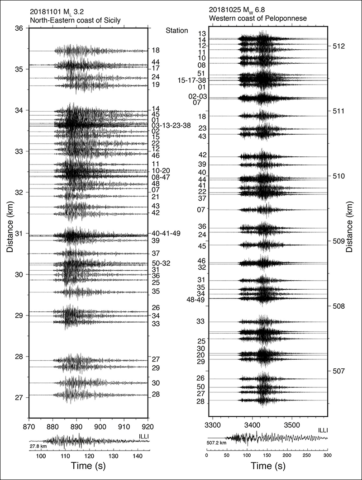
We collected more than 300 gigabytes of data, which include local, regional, and teleseismic (distant) earthquakes as well as ambient noise and volcanic tremor data. During the period of the experiment, about 50 earthquakes occurred within 100 kilometers of Lipari. Half of these had magnitudes of less than 2, but we also recorded 18 events larger than M 5 that occurred in the region and farther away. In Figure 3, we show two examples of recorded seismic waveforms from an ML 3.2 local earthquake and an Mw 6.8 regional earthquake.
We aim to investigate in detail the crust and upper mantle beneath Lipari Island using receiver functions to characterize Earth’s structural response near the instrument and regional tomography to construct a three-dimensional image of Earth’s nearby interior. We will also analyze ambient noise and local volcanic tremors.
We plan to merge the seismic data set with other observables such as geochemical measurements and structural data to get a more robust and complete picture of the tectonic setting. We will apply modern and sophisticated processing and analysis techniques used in seismological studies to the nodal seismic array data.
The deployment of nodal arrays fills a unique niche in monitoring active volcanoes. In comparison to traditional portable seismic stations, nodal arrays enable a high-quality data set to be obtained over a short deployment period, at lower costs, with easier site selection capabilities, and with easy and quick installation procedures.
Our collaborative field experiment is the latest vehicle for learning about the seismic structure of Lipari and an excellent approach to linking the unrest at depth to volcanic and hydrothermal activity at the surface in similar settings. This project will contribute to the evaluation of the geohazards of the Mediterranean region, where the African and Eurasian plates converge.
Acknowledgments
We thank Comune di Lipari for hosting the experiment and INGV Catania and Lipari Observatory (L. Pruiti) for the logistical support. We are grateful to R. Vilardo and M. Martinelli of the Polo Museale di Lipari, Regione Sicilia; the Hotel Antea; Co.Mark and Tenuta Castellaro; and Alessandro (a grocery store) in Acquacalda for hosting some nodes of the experiment. We thank INGV Roma 1 for funding and supporting the project and the Department of Geology and Geophysics at LSU for supporting this project. A.E. was funded by INGV Osservatorio Nazionale Terremoti (ONT). LSU students R. Ajala and E. McCullison assisted with the deployment setup and preparation of the nodes. Data will be available in November 2020 (2 years after the last instrument was retrieved from the field) by contacting the corresponding author.
References
Barreca, G., et al. (2014), New insights in the geodynamics of the Lipari–Vulcano area (Aeolian Archipelago, southern Italy) from geological, geodetic and seismological data, J. Geodyn., 82, 150–167, https://doi.org/10.1016/j.jog.2014.07.003.
Cucci, L., et al. (2017), Vein networks in hydrothermal systems provide constraints for the monitoring of active volcanoes, Sci. Rep., 7, 46, https://doi.org/10.1038/s41598-017-00230-8.
De Astis, G., G. Ventura, and G. Vilardo (2003), Geodynamic significance of the Aeolian volcanism (southern Tyrrhenian Sea, Italy) in light of structural, seismological, and geochemical data, Tectonics, 22(4), 1040, https://doi.org/10.1029/2003TC001506.
Farrell, J., et al. (2018), Seismic monitoring of the 2018 Kilauea eruption using a temporary dense geophone array, Abstract V41B-07 presented at 2018 Fall Meeting, AGU, Washington, D.C., 10–14 Dec.
Gasparini, G., et al. (1982), Seismotectonics of the Calabrian Arc, Tectonophysics, 84, 267–286, https://doi.org/10.1016/0040-1951(82)90163-9.
Hansen, S. M., and B. Schmandt (2015), Automated detection and location of microseismicity at Mount St. Helens with a large-N geophone array, Geophys. Res. Lett., 42, 7,390–7,397, https://doi.org/10.1002/2015GL064848.
Milano, G., G. Vilardo, and G. Luongo (1994), Continental collision and basin opening in southern Italy: A new plate subduction in the Tyrrhenian Sea?, Tectonophysics, 230, 249–264, https://doi.org/10.1016/0040-1951(94)90139-2.
Ryan, W. B. F., et al. (2009), Global Multi-Resolution Topography synthesis, Geochem. Geophys. Geosyst., 10, Q03014, https://doi.org/10.1029/2008GC002332.
Ward, K. M., and F.-C. Lin (2017), On the viability of using autonomous three-component nodal geophones to calculate teleseismic Ps receiver functions with an application to Old Faithful, Yellowstone, Seismol. Res. Lett., 88(5), 1,268–1,278, https://doi.org/10.1785/0220170051.
Author Information
Francesca Di Luccio ([email protected]), Istituto Nazionale di Geofisica e Vulcanologia, Rome, Italy; Patricia Persaud, Department of Geology and Geophysics, Louisiana State University, Baton Rouge; Luigi Cucci, Alessandra Esposito, and Guido Ventura, Istituto Nazionale di Geofisica e Vulcanologia, Rome, Italy; and Robert W. Clayton, Seismological Laboratory, California Institute of Technology, Pasadena
Citation:
Di Luccio, F.,Persaud, P.,Cucci, L.,Esposito, A.,Ventura, G., and Clayton, R. W. (2019), Seismic sensors probe Lipari’s underground plumbing, Eos, 100, https://doi.org/10.1029/2019EO125333. Published on 15 July 2019.
Text © 2019. The authors. CC BY-NC-ND 3.0
Except where otherwise noted, images are subject to copyright. Any reuse without express permission from the copyright owner is prohibited.

