
As a rule, when tectonic plates made of dense oceanic crust material meet plates of more buoyant continental crust material, the oceanic plate moves beneath the continental plate and sinks into the mantle in a process known as subduction. Occasionally, however, a process called obduction thrusts sheets of oceanic crust and upper mantle rocks over the top of less dense continental material [Coleman, 1981]. Although obduction is regarded as a geodynamic anomaly [Agard et al., 2014], it is not an uncommon occurrence.
The evidence of such a process is contained in ophiolites, sequences of oceanic crust and upper mantle rocks found near the surfaces of continents. By far the largest, best exposed, and most studied ophiolite complex is the Semail ophiolite in the eastern corner of the Arabian Peninsula, spanning Oman and the United Arab Emirates (UAE) [Glennie et al., 1973; Lippard et al., 1986; Searle and Cox, 1999].
The middle to lower crustal structure of the UAE-Oman mountains remains an enigma.
Although scientists have mapped and studied the surface geology of this region in detail, the middle to lower crustal structure of the UAE-Oman mountains remains an enigma. Despite more than 40 years of detailed geological studies, a lack of high-resolution geophysical imaging beneath the UAE-Oman mountains remains.
In an attempt to unravel the structure beneath both the Semail ophiolite and the underlying crust of the UAE-Oman mountain range, scientists from the Petroleum Institute, Abu Dhabi (UAE), have teamed up with geologists and geophysicists from the University of Oxford. Their detailed geophysical and geological observations represent significant progress toward solving the ongoing debates about the ophiolite emplacement processes.
Evidence of Past Events
From middle Permian to mid-Cretaceous times (about 270 to 95 million years ago), the Arabian margin was a tectonically stable, passive, dominantly carbonate continental margin. During the Cenomanian–Turonian time (about 96 million years ago), the Semail ophiolite formed in the Tethyan region to the northeast as a result of a subduction-obduction process that thrust thin-skinned Tethyan oceanic sheets onto the collapsed continental margin. Flexural loading of the thrust sheets caused a foreland basin, the Aruma basin, to develop in front of the obducting ophiolite.
The UAE-Oman mountains are 150 kilometers wide and stretch for 700 kilometers, and they expose the Semail ophiolite thrust sheet, which is roughly 15–20 kilometers thick. Beneath the exceptionally well preserved Semail ophiolite, a series of thrust sheets of oceanic sedimentary and basaltic rocks, emplaced from northeast to southwest, separates the overlying ophiolite from the Arabian continental rocks beneath.
The structural fabric of these thrust sheets can be reconstructed to gain an understanding of the paleogeography of the Tethys Ocean that lay adjacent to the Arabian plate during Cretaceous times. The most distal thrust sheets (farthest from the areas of geologic activity) include deep-sea sediments, including cherts, radiolarian oozes, carbonate seamounts, and basalts, that immediately underlie the ophiolite. Restoration of thrust sheets between the ophiolite and the Arabian margin reveal more than 200 kilometers of horizontal shortening and thrusting [Searle et al., 2015].
Along the base of the ophiolite thrust sheet, irregular occurrences of metamorphic rocks, amphibolites, and greenschists are termed the “metamorphic sole.” Constraining the pressure, depth, temperature, and timing of metamorphism in these rocks enables us to reconstruct processes operating during oceanic subduction and ophiolite formation.
One unique thrust slice, the Bani Hamid thrust sheet in the northern Oman-UAE mountains, shows a 1-kilometer-thick sequence of extremely high grade marbles and quartzites (granulite facies). This sequence was formed during the latter part of the obduction process, when these buoyant rocks were jammed in the subduction zone and then thrust into the middle of the ophiolite [Searle et al., 2015]. The thickness of the ophiolite thrust sheet and the structures in the underlying deeper part of the mountain belt, however, remain poorly known.
Unanswered Questions
Two aspects of ophiolite research remain controversial: the tectonic setting of an ophiolite’s origin (mid-ocean ridge, suprasubduction zone, transform fault) and the mechanism of their emplacement onto continental margins.
Detailed geochemical analyses of the crustal components provide information on the tectonic setting. Constraints on the geochronology of events are provided by uranium-lead isotopic ages from ophiolite crustal rocks and amphibolite minerals in the metamorphic sole. The mechanism of emplacement of large thrust sheets of dense ophiolite rocks onto more buoyant continental crust is determined from detailed structural mapping of the ophiolite and thrust sheets beneath combined with geochronological constraints.
Surface mapping can, however, examine only the upper crustal rocks that are exposed. We rely purely on geophysical methods to determine the structure of the deep, unexposed parts of the crust.
Collecting Geophysical Data
To illuminate the crustal and upper mantle structure beneath the UAE-Oman mountains, the research team carried out the first integrated seismic reflection and refraction experiment in the UAE-Oman region in July 2014. Passive and active seismic techniques will be used to construct new images of the structure of the crust, which will be verified by potential field (gravity, magnetic) modeling. The scientists also plan to acquire vibroseis seismic data, in which a “thumper truck” generates vibrations in the ground, in early 2016 to complement the existing data set (Figure 1).
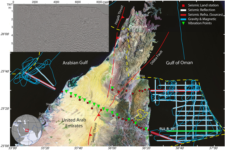
Seismic reflection data were acquired along a grid of lines totaling 925 kilometers in the Arabian Gulf and Gulf of Oman (Figure 1) using the survey ship M/V Hawk Explorer. The ship towed an array of air guns (total volume of 7060 cubic inches, 116 liters) for generating seismic waves and a 5-kilometer-long multichannel streamer to record reflections from subseafloor sediments and basement rocks.
Seismic refraction data were acquired along selected reflection lines using 25 broadband land recording stations. The refraction data consisted of about 800 air gun shots fired at 50-second time intervals. Gravity and magnetic data were continuously collected throughout the cruise. Similar data will also be acquired along the east–west onshore refraction transects and will be integrated with existing onshore and offshore data.
Broadband seismometers are currently recording teleseismic earthquakes (more than 1000 kilometers from the measurement site). Analysis of three-component wave fronts and shear-wave splitting from these data will provide new insights into the deep lithospheric structure and degree of anisotropy, respectively.
We anticipate that in the near future, the instruments will be moved to different locations within the UAE. This relocation will augment the existing national seismic network, and the resulting data set will be used to apply additional passive techniques (e.g., ambient noise tomography) and to study the earthquake hazards in the country. These sensors will extend the array coverage of the mountains, which, coupled with cutting-edge tomographic inversion techniques for analyzing seismic data, could potentially play a major role in deciphering the tectonics of the region. In addition, a detailed surface geology map of the ophiolite will be produced for the area across the two seismic refraction profiles.
Applying the Data to Key Scientific Questions
As discussed above, much of the controversy surrounding ophiolites around the world concerns their origin, tectonic setting, and the mechanism of emplacement onto continental crust. The Oman-UAE mountains have proved critical to the general understanding of ophiolites because they have been mapped in great detail and have been subject to extensive high-precision geochemical and geochronological analyses that constrain the igneous history and metamorphic evolution of the sole amphibolites.
Project scientists believe that the ongoing debates about ophiolite formation and emplacement cannot be solved without further detailed geophysical and geological observations.
The rocks of the Bani Hamid thrust sheet in the northern Oman-UAE mountains constrain the metamorphic history of the subophiolite rocks that pin down both timing and depths of metamorphism [Searle et al., 2015]. The thickness of the ophiolite thrust sheet and the structures in the underlying deeper part of the mountain belt, however, remain poorly understood. Part of the reason for this is the lack of high-resolution geophysical imaging. Despite the abundance of recent geological and geochemical data interpretations, including those of the Semail ophiolite, project scientists believe that the ongoing debates about ophiolite formation and emplacement cannot be solved without further detailed geophysical and geological observations.
Moving forward, we will investigate various scenarios by combining new geophysical evidence, structural mapping, and geochemical analysis of rock sample data. We hope that the new data will shed light on critical structural questions and processes such as the following:
- the geometry of thrust sheets beneath the Semail ophiolite
- the structure of the Hagab thrust beneath the Musandam culmination that reflects the initial continental collision
- how the older obduction-related thrust sheets affect the Hagab-type thrusts
- the deep crustal structure of the northeastern margin of the Arabian plate
- the velocity structure of the crust and uppermost mantle beneath the orogenic belt and the flanking UAE foreland basin and Gulf of Oman rifted margin
The seismic refraction profiles will ensure that meaningful inferences can be made on the main structural elements of the crust and upper mantle beneath the mountain belts and adjacent regions. Together with evidence from active source seismology and gravity and magnetic anomalies, the data will determine the offshore extent of the ophiolite and inform assessments of resources, including oil and gas.
These results will also enable us to determine whether or not the ophiolite is detached from Tethyan oceanic lithosphere in the Gulf of Oman by a continental basement ridge, as postulated by Ravaut et al. [1997]. Passive seismic methodologies (e.g., seismic tomography and receiver function analysis) will provide relatively low resolution images of the crust, but they have the potential to provide insights into the deep structure of the subcrustal lithospheric mantle underlying the mountain belt and adjacent regions.
We strive to address major questions concerning the structure and emplacement of the Semail ophiolite and to contribute to the understanding of ophiolite complexes around the world. Early results are expected to be published in 2016.
Acknowledgments
The project is funded by the Petroleum Institute Research Centre (PIRC), with additional support from the UAE government and Schlumberger. The UAE Ministry of Energy provided logistical support and necessary approvals. The offshore data were acquired by Seabird Exploration on board M/V Hawk Explorer.
References
Agard, P., X. Zuo, F. Funiciello, N. Bellahsen, C. Faccenna, and D. Savva (2014), Obduction: Why, how and where. Clues from analog models, Earth Planet. Sci. Lett., 393, 132–145.
Coleman, R. G. (1981), Tectonic setting for ophiolite obduction in Oman, J. Geophys. Res., 86(B4), 2497–2508.
Glennie, K. W., M. G. A. Boeuf, M. H. Clarke, M. Moody-Stuart, W. F. H. Pilaar, and B. M. Reinhardt (1973), Late Cretaceous nappes in Oman Mountains and their geologic evolution, AAPG Bull., 57(1), 5–27.
Lippard, S. J., A. W. Shelton, and I. G. Gass (1986), The Ophiolite of Northern Oman, 178 pp., Blackwell Sci., Oxford, U.K.
Ravaut, P., R. Bayer, R. Hassani, D. Rousset, and A. Al Yahya’ey (1997), Structure and evolution of the northern Oman margin: Gravity and seismic constraints over the Zagros-Makran-Oman collision zone, Tectonophysics, 279(1), 253–280.
Searle, M. P., and J. Cox (1999), Tectonic setting, origin and obduction of the Oman ophiolite, Geol. Soc. Am. Bull., 111, 104–122.
Searle, M. P., D. Waters, J. Garber, M. Rioux, A. Cherry, and T. Ambrose (2015), Structure and metamorphism beneath the obducting Oman ophiolite: Evidence from the Bani Hamid granulites, northern Oman mountains, Geosphere, 11(6), 1–25, doi:10.1130/GES01199.1.
Author Information
Simone Pilia and Mohammed Y. Ali, Department of Petroleum Geosciences, The Petroleum Institute, Abu Dhabi, UAE; email: [email protected]; and Anthony B. Watts and Michael P. Searle, Department of Earth Sciences, University of Oxford, South Park Road, Oxford, U.K.
Citation: Pilia, S., M. Y. Ali, A. B. Watts, and M. P. Searle (2015), UAE-Oman mountains give clues to oceanic crust and mantle rocks, Eos, 96, doi:10.1029/2015EO040937. Published on 9 December 2015.
Text © 2015. The authors. CC BY 3.0
Except where otherwise noted, images are subject to copyright. Any reuse without express permission from the copyright owner is prohibited.