Space-based Earth observations are critical in advancing both our fundamental understanding of how the planet operates and our ability to monitor, predict, and respond to changes on short and long timescales. To prioritize Earth observation needs for the next decade, the National Academy of Sciences developed a short list of high-priority observing systems called “designated observables” according to the 2017 decadal survey for Earth observation from space, the most recent survey. One of the designated observables is Surface Biology and Geology (SBG), which addresses critical scientific questions and topics with respect to ecology and biodiversity (terrestrial and aquatic), hydrology, physical geography, solid Earth science, and societally beneficial applications relevant to each of these areas.
What are the structure, function, and biodiversity of Earth’s ecosystems, and how and why are they changing in time and space?
NASA initiated a new study to assess plans and potential architectures for an observing system that will help achieve the goals of the SBG designated observables. Designing such an observing system includes choosing sensors and one or more spacecraft or aircraft, among other factors. SBG targets several focus areas that were listed as “most important” in the 2017 decadal survey. Some of the science questions related to these focus areas are novel for NASA’s Earth science efforts, including one that addresses the diversity of life on Earth: “What are the structure, function, and biodiversity of Earth’s ecosystems, and how and why are they changing in time and space?”
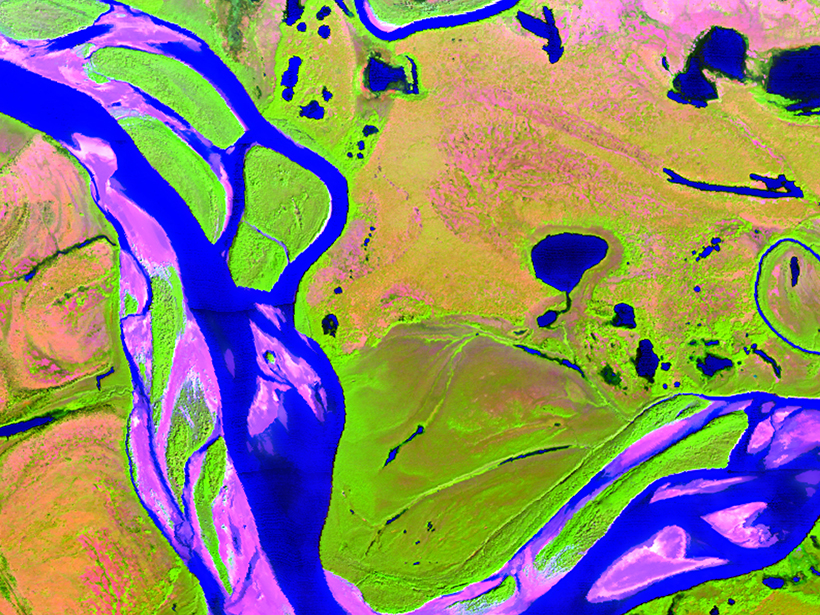
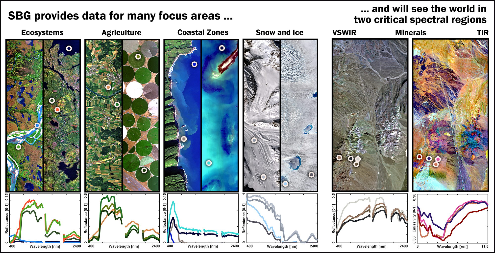
The SBG designated observable effort is concerned with collecting visible through shortwave infrared (VSWIR) and thermal infrared (TIR) spectroscopic imagery at moderately high spatial resolution (tens of meters) and moderate temporal resolution (days to weeks). Figure 1 illustrates the variation of spectra in the VSWIR and TIR range that SBG could measure to characterize various surface types on Earth.
At the 2019 SBG Community Workshop, 174 attendees (including 25 remote attendees) updated the scientific community and other potential users on the current SBG study plan and the effort’s four working groups: Algorithms, Calibration/Validation, Modeling, and Applications. The SBG Research and Applications coleaders, David Schimel from NASA’s Jet Propulsion Laboratory (JPL) and Betsy Middleton from NASA’s Goddard Space Flight Center (GSFC), led the workshop, which was held 12–14 June in Washington, D.C.
Applying the Observations
Some of the systems that SBG will help to quantify include flows of energy, carbon, water, nutrients, and other substances sustaining the life cycle of terrestrial and marine ecosystems. This knowledge will improve our understanding of fluxes between ecosystems and the atmosphere, the ocean, and the solid Earth.
Other applications include repeated observations of volcanic surface materials and emissions, which could inform forecasts of large-scale geological hazards on societally relevant timescales. SBG will also deepen investigations of evapotranspiration and snow, helping address how the global water cycle is changing over time, and supporting myriad socially beneficial applications ranging from biodiversity conservation to oil spill management.
In a range of talks and 52 poster communications, presenters at the workshop highlighted the interdisciplinary science enabled by global VSWIR and TIR imagery and the relevance of SBG’s key science objectives.
SBG will support forecasting for ecosystem management, water resources, and health and air quality, and support disaster response efforts.
Gregory Asner, director of the Center for Global Discovery and Conservation Science at Arizona State University, emphasized the need for researchers to develop global biodiversity products together with policy makers to increase the impact of the Earth observations. This has been done in Peru and Borneo, for example, where imaging spectroscopy has helped plan new national parks.
“This community has been in [airborne] campaign mode,” said Douglas Morton, chief of the Biospheric Sciences Laboratory at NASA GSFC. He pointed out the transformative science that could emerge from repeated global coverage by combined VSWIR and TIR measurements, which have benefits for studying snow hydrology and ecosystem functioning, as well as the mapping of minerals and volcanic activities.
In a similar vein, Frank Müller-Karger, a professor of biological oceanography and remote sensing at the University of South Florida, highlighted the use of cross-disciplinary science to understand links that sustain life on Earth and the need for observations at high temporal frequency to study coastal and inland aquatic ecosystems.
Besides fundamental science questions, SBG will address a range of applications, as Christine Lee of the Science Applications and Data Interactions group at NASA JPL and Stephanie Uz, Applied Sciences Manager at NASA GSFC, pointed out. Such applications include supporting forecasting for ecosystem management, water resources, and health and air quality, as well as supporting disaster response efforts. A high-resolution thermal imager will support studies informing questions in not only global hydrology, agriculture, and early warning of geological hazards but also public health, heat islands, and urban planning.
Building Workflows for Data Processing and Product Generation
At the workshop, the SBG working groups updated attendees on the status of their projects and outlined how their work fits into the program’s overall framework. The Algorithms Working Group has collected an extensive set of more than 100 published candidate algorithms for use in addressing the broad range of possible SBG focus areas and science questions. From this initial list, a smaller set of core algorithms will be chosen for implementation.
The group provided an example that illustrated an algorithm workflow for vegetation mapping, going from raw instrument data to analysis-ready products. Workflows for data storage and transmittance from the instrument, geolocation, and radiance calibration are needed to generate geolocated and calibrated at-sensor radiance data. Radiance spectra are corrected for effects from the atmosphere, surface anisotropy (bidirectional reflectance distribution function effects), and topography to produce surface reflectance data. In this example, surface reflectance estimates were then converted into estimates of, for instance, plant functional traits such as leaf carbon and nitrogen and leaf mass per area, and then into assessments of plant functional diversity or other derived products.
The Calibration/Validation Working Group discussed various options to ensure the quality of the products and provide a means for uncertainty estimation, from prelaunch sensor characterization and onboard calibration to vicarious calibration and validation and collaboration with international partners to maintain a ground network of calibration and validation sites.
The Modeling Working Group presented a framework for observing system simulation experiments, which would evaluate algorithms and sensor characteristics with respect to uncertainty propagation from raw data to finished products. The modeling framework will enable the evaluation of alternate spacecraft and observing system architectures (e.g., with single versus multiple spacecraft and different levels of sensor performance).
Priorities and Targets
Finally, workshop participants provided feedback on the Science and Applications Traceability Matrix (SATM). The leads of the SBG study team are developing the SATM with contributions from the members of the working groups and workshop participants to assist in defining priorities and measurement targets. The Applications Working Group also presented its separate Applications Traceability Matrix, which is far more extensive than the SATM and offers a place to report a wider range of applications that SBG can enable. Feedback from the workshop and working group participants is currently being incorporated into the SATM, resulting in a community consensus about the mission’s primary goals and measurement targets.
“We are on an incredibly fast schedule,” Turner said, and “we need to know your needs!”
SBG’s observing system design was still fully open for input at the time of the workshop, but decisions will be made quickly to narrow down architecture candidates in the next study phase. Possibilities range from multiple small satellites to a single flagship satellite, and observing system capabilities could range from providing global coverage with a fixed observation geometry to providing more focused coverage with instruments pointed at smaller areas of interest, according to Anthony Freeman, program manager of JPL’s Innovation Foundry.
“We are at the maximum point of openness,” said David Schimel, “and we want the disciplines to work together to find the sweet spot for this observing system…. Metrics should not be biased to certain fields…and overlap between focus areas will be highly rated in the value framework.”
Woody Turner from NASA Headquarters encouraged people to get involved in the working groups. “We are on an incredibly fast schedule,” Turner said, and “we need to know your needs!”
Moving Ahead
The working group leads met with the SBG study team leads in August 2019 to finalize an updated version of the SATM that will be open for further comments. A public website is now available for community input and updates.
Next steps for the observing system study focus on evaluating many options for implementing the critical Earth observations. Emphasis will be placed on achieving frequent revisits with high spatial resolution to capture variability and on high-performance spectral and thermal imagers to enable quantitative estimates of critical variables in ecosystems, hydrology, geology, weather, and climate.
The study is evaluating approaches ranging from traditional spacecraft options to innovative “new space” technologies that rely on multiple low-cost platforms. The evaluation process will score the science value of various ways of implementing the observing system, while also considering schedule, cost, and technical risk. Once a small set of high-value architectures is identified, more detailed designs will be developed, evaluated in detail, and presented to NASA to select the approach to be implemented, with the goal of a launch in the late 2020s.
Acknowledgments
The research carried out at the Jet Propulsion Laboratory, California Institute of Technology, was under a contract with NASA. Government sponsorship is acknowledged. Data used for Figure 1 can be accessed through the Airborne Visible-Infrared Imaging Spectrometer (AVIRIS) data portals at https://avirisng.jpl.nasa.gov/alt_locator/, https://aviris.jpl.nasa.gov/alt_locator/.
Author Information
Fabian D. Schneider ([email protected]), António Ferraz, and David Schimel, NASA Jet Propulsion Laboratory, California Institute of Technology, Pasadena
Citation:
Schneider, F. D.,Ferraz, A., and Schimel, D. (2019), Watching Earth’s interconnected systems at work, Eos, 100, https://doi.org/10.1029/2019EO136205. Published on 31 October 2019.
Text © 2019. California Institute of Technology.
Except where otherwise noted, images are subject to copyright. Any reuse without express permission from the copyright owner is prohibited.
Text © 2019. California Institute of Technology.
Except where otherwise noted, images are subject to copyright. Any reuse without express permission from the copyright owner is prohibited.