
In some areas of the Amazon rainforest, trees green up as a response to drought, while in others they die off. Scientists are trying to understand why.
remote sensing
Posted inEditors' Highlights
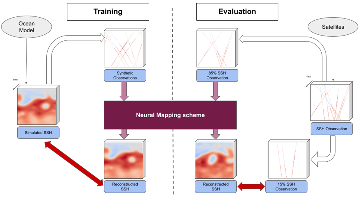
Physics + Machine Learning Provide a Better Map of Ocean Measurements
A new study offers a compelling example where the merger of dynamical modeling, machine learning, and ocean measurements enhances oceanographic understanding, monitoring, and mapping.
Posted inResearch Spotlights
断裂成熟度和断裂走向,哪个对大地震更重要?
对青藏高原2021年玛多地震的详细研究表明,与先前的假设相反,断裂走向对地震破裂动力学特征的影响有时会超过断裂成熟度的影响。

Posted inNews
Las estrellas lejanas resaltan minilunas en los anillos de Saturno
Al estudiar cómo la luz de las estrellas se atenúa al viajar a través de las partículas de hielo que rodean a Saturno, investigadores han hecho foco en muchas estructuras pequeñas en los famosos anillos del gigante gaseoso.

Posted inNews
Distant Stars Spotlight Mini Moons in Saturn’s Rings
By studying how starlight attenuates as it travels through the icy particles encircling Saturn, researchers have zoomed in on a host of small structures in the gas giant’s famous rings.

Posted inOpinions
Global Change Research for a More Secure World
Orienting global change science so that it informs national security issues will help us develop interventions that promote social stability and ecological well-being.
Posted inEditors' Vox
Harmonizing Theory and Data with Land Data Assimilation
Land data assimilation advances scientific understanding and serves as an engineering tool for land surface process studies, reflecting the trend of harmonizing theory and data in the big data era.

Posted inResearch Spotlights
Beneath the Ice: Greenland’s Geology Revealed in New Map
Advances in remote sensing offered an opportunity to redraw Greenland’s geologic map for the first time in 15 years.

Posted inResearch Spotlights
Fault Maturity or Orientation: Which Matters More for Quakes?
Close examination of a 2021 earthquake on the Tibetan Plateau provides hints that, counter to prior assumptions, the influence of fault orientation can sometimes trump that of maturity.

Posted inNews
Low-Level Clouds Disappear During a Solar Eclipse
Cumulus clouds rapidly dissipate as the land surface cools, a finding that has implications for Sun-obscuring geoengineering efforts.