• About
  • Special Reports
  • Topics
    • Climate
    • Earth Science
    • Oceans
    • Space & Planets
    • Health & Ecosystems
    • Culture & Policy
    • Education & Careers
    • Opinions
  • Projects
    • Postcards From the Field
    • ENGAGE
    • Editors’ Highlights
    • Editors’ Vox
    • Eos en Español
    • Eos 简体中文版
    • Print Archive: 2015–2025
  • Policy Tracker
  • Blogs
    • Research & Developments
    • The Landslide Blog
  • Newsletter
  • Submit to Eos
  • AGU.org
  • Career Center
  • Join AGU
  • Give to AGU
  • About
  • Special Reports
  • Topics
    • Climate
    • Earth Science
    • Oceans
    • Space & Planets
    • Health & Ecosystems
    • Culture & Policy
    • Education & Careers
    • Opinions
  • Projects
    • Postcards From the Field
    • ENGAGE
    • Editors’ Highlights
    • Editors’ Vox
    • Eos en Español
    • Eos 简体中文版
    • Print Archive: 2015–2025
  • Policy Tracker
  • Blogs
    • Research & Developments
    • The Landslide Blog
  • Newsletter
  • Submit to Eos
Skip to content
  • AGU.org
  • Career Center
  • Join AGU
  • Give to AGU
Eos

Eos

Science News by AGU

Support Eos
Sign Up for Newsletter
  • About
  • Special Reports
  • Topics
    • Climate
    • Earth Science
    • Oceans
    • Space & Planets
    • Health & Ecosystems
    • Culture & Policy
    • Education & Careers
    • Opinions
  • Projects
    • Postcards From the Field
    • ENGAGE
    • Editors’ Highlights
    • Editors’ Vox
    • Eos en Español
    • Eos 简体中文版
    • Print Archive: 2015–2025
  • Policy Tracker
  • Blogs
    • Research & Developments
    • The Landslide Blog
  • Newsletter
  • Submit to Eos

forecasting

Vertical streaks of digital ones and zeroes rise from digitized representation of Earth against a deep blue background.
Posted inOpinions

We Need a Better Way to Share Earth Observations

by Zhong Liu, Yixin Wen, Vasco Mantas and David Meyer 12 May 20236 October 2026

A more accessible, open data-sharing infrastructure will engage a broader community of contributors, helping to develop satellite data products that benefit Earth science research and applications.

Graph from the paper
Posted inEditors' Highlights

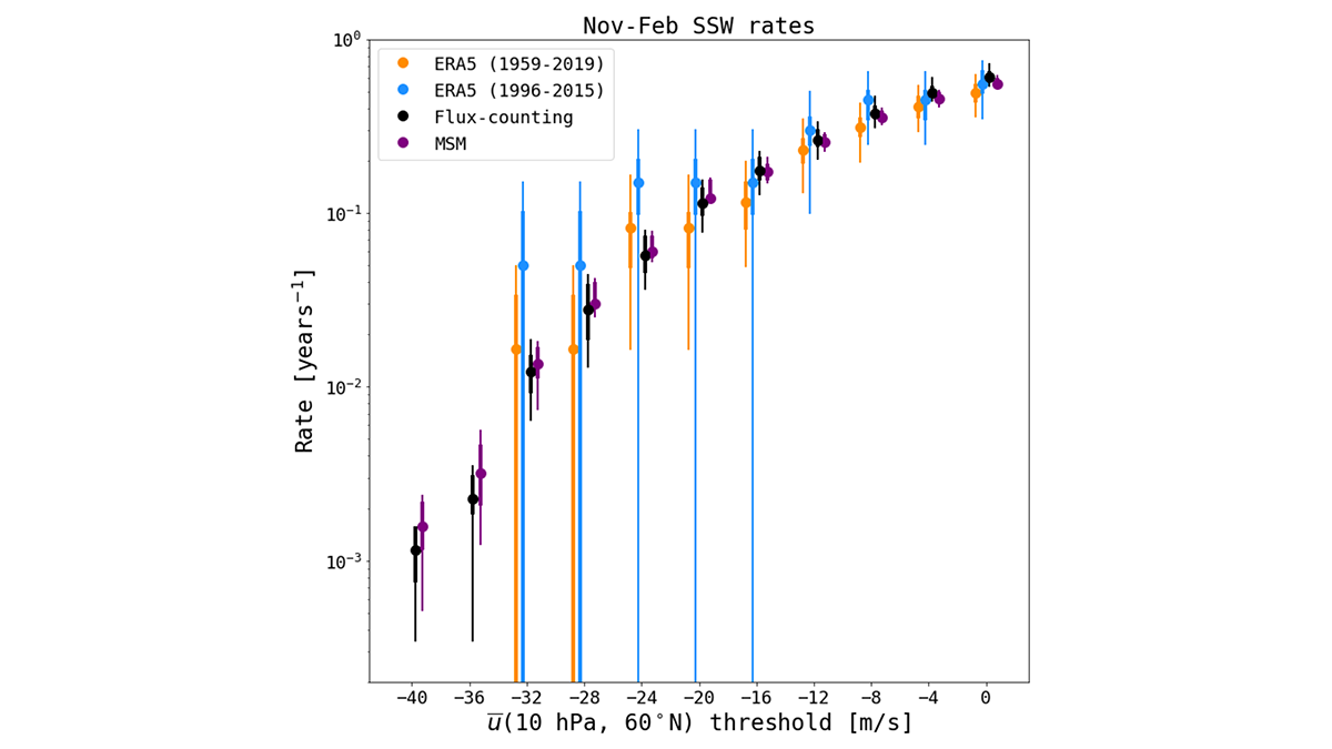
Quantifying Extreme Events from Short Weather Forecast Data

by Sarah Kang 13 April 202310 April 2023

Subseasonal weather forecast ensembles are a useful tool for overcoming the inherent difficulty of quantifying extreme weather risk caused by data scarcity.

A blue truck with a tall pole and a large, gray circular device is parked on a street next to a person. A tornado spins in a field far in the background.
Posted inNews

Tornadoes’ Fastest Winds Howl Close to the Ground

by Carolyn Wilke 3 April 20235 April 2023

Radar data from storm-tracking scientists reveal that twisters’ winds churn 30% faster near Earth’s surface than above 100 meters, where measurements usually are taken.

Satellite image of tan whisps of clouds over green land. There is brown land to the right and blue ocean to the left.
Posted inNews

Extreme Wildfires Make Their Own Weather

by Elise Cutts 8 March 202313 March 2023

Extreme fires in the western United States and Southeast Asia influenced the local weather in ways that make fires and smoke pollution worse.

Aerial photo of the San Andreas Fault
Posted inNews

Accounting for Offbeat Earthquakes Could Improve Forecasts

by Erin Martin-Jones 2 March 20232 March 2023

A new model considers the full history of earthquakes on a fault, improving forecasts of when the next will strike.
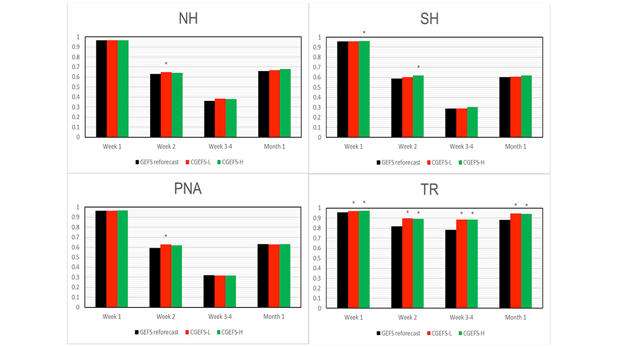
Four bar graphs from the paper.
Posted inEditors' Highlights

A New Coupled Modeling System Improves Forecast Skills

by Minghua Zhang 27 February 202322 February 2023

Building on older versions, the new Global Ensemble Forecast System with coupled atmosphere-land-ocean-ice-wave models has better forecasting skills of the atmosphere than the uncoupled system.
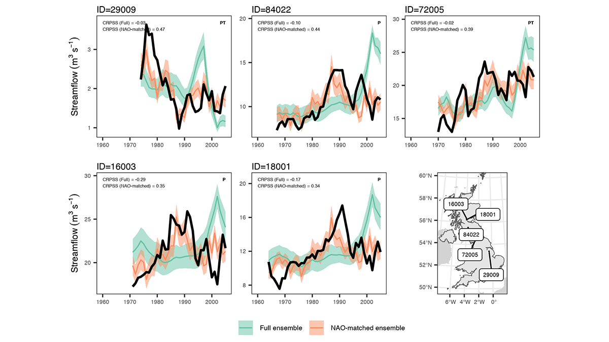
Graphs showing examples of predicted extreme streamflow in catchments.
Posted inEditors' Highlights

Predicting Flood Conditions in the Next Few Years

by Valeriy Ivanov 7 February 20237 June 2023

Multiyear flood predictions are possible for watersheds in which the magnitude and frequency of flooding can be related to an atmospheric pressure see-saw in the North Atlantic region.

A drone hovers over a beach.
Posted inNews

Drones Make Weather Prediction Easier at the Poles

by Andrew Chapman 23 December 202223 December 2022

Researchers measured wind speed with a commercially available drone and a lightweight sensor. The approach could help scientists gather more data from remote environments.

3D rendering of Earth
Posted inFeatures

Are We Entering the Golden Age of Climate Modeling?

Mark Betancourt, Freelance Journalist by Mark Betancourt 21 November 20225 November 2025

Thanks to the advent of exascale computing, local climate forecasts may soon be a reality. And they’re not just for scientists anymore.

A mass of steaming, orange-glowing lava consumes a street sign as it flows over a roadway.
Posted inResearch Spotlights

A Better Operational Lava Flow Model

by Morgan Rehnberg 26 October 202226 October 2022

By segmenting the vertical structure of a lava flow, the Lava2d model provides more realism to operational lava forecasts.

Posts pagination

Newer posts 1 … 7 8 9 10 11 … 28 Older posts
Over a dark blue-green square appear the words Special Report: The State of the Science 1 Year On.

Features from AGU Publications

Research Spotlights

Rapid-Scan Satellite Data Offer Clues to Typhoon Intensity

17 November 202617 November 2026
Editors' Highlights

Soil Water Content Determined by Elastic Wave Dispersion

17 November 202616 November 2026
Editors' Vox

Announcing the New AGU Publications Editors-in-Chief Starting in 2027

6 November 20266 November 2026
Eos logo at left; AGU logo at right

About Eos
ENGAGE
Awards
Contact

Advertise
Submit
Career Center
Sitemap

© 2026 American Geophysical Union. All rights reserved Powered by Newspack