• About
  • Special Reports
  • Topics
    • Climate
    • Earth Science
    • Oceans
    • Space & Planets
    • Health & Ecosystems
    • Culture & Policy
    • Education & Careers
    • Opinions
  • Projects
    • Postcards From the Field
    • ENGAGE
    • Editors’ Highlights
    • Editors’ Vox
    • Eos en Español
    • Eos 简体中文版
    • Print Archive: 2015–2025
  • Policy Tracker
  • Blogs
    • Research & Developments
    • The Landslide Blog
  • Newsletter
  • Submit to Eos
  • AGU.org
  • Career Center
  • Join AGU
  • Give to AGU
  • About
  • Special Reports
  • Topics
    • Climate
    • Earth Science
    • Oceans
    • Space & Planets
    • Health & Ecosystems
    • Culture & Policy
    • Education & Careers
    • Opinions
  • Projects
    • Postcards From the Field
    • ENGAGE
    • Editors’ Highlights
    • Editors’ Vox
    • Eos en Español
    • Eos 简体中文版
    • Print Archive: 2015–2025
  • Policy Tracker
  • Blogs
    • Research & Developments
    • The Landslide Blog
  • Newsletter
  • Submit to Eos
Skip to content
  • AGU.org
  • Career Center
  • Join AGU
  • Give to AGU
Eos

Eos

Science News by AGU

Support Eos
Sign Up for Newsletter
  • About
  • Special Reports
  • Topics
    • Climate
    • Earth Science
    • Oceans
    • Space & Planets
    • Health & Ecosystems
    • Culture & Policy
    • Education & Careers
    • Opinions
  • Projects
    • Postcards From the Field
    • ENGAGE
    • Editors’ Highlights
    • Editors’ Vox
    • Eos en Español
    • Eos 简体中文版
    • Print Archive: 2015–2025
  • Policy Tracker
  • Blogs
    • Research & Developments
    • The Landslide Blog
  • Newsletter
  • Submit to Eos

Journal of Geophysical Research: Solid Earth

Visit the journal.

Illustration of the transport of magmatic and meteoric fluids in the upper crust.
Posted inEditors' Highlights

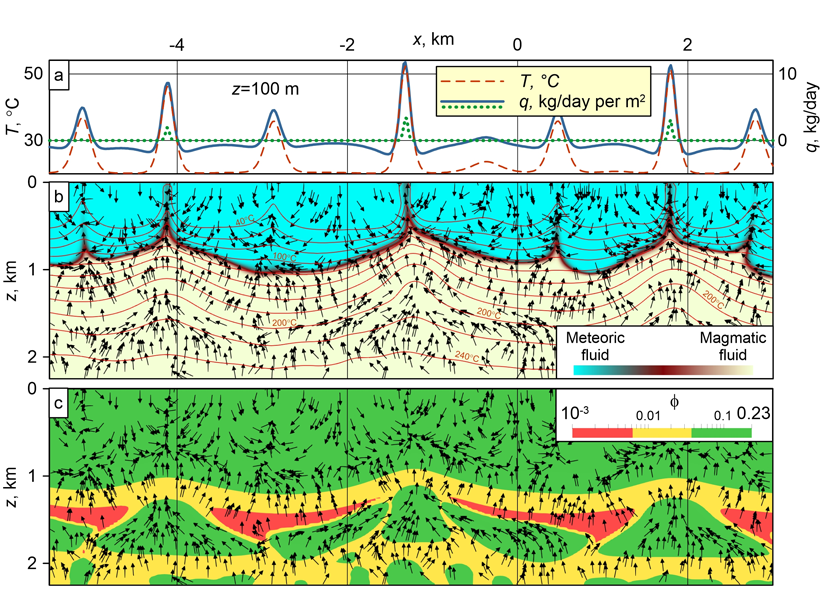
Coupled Mechanisms of Fluid Transport Across the Crust

by Beatriz Quintal 14 September 202111 May 2022

Magmatic fluid moves up in the ductile zone through porosity waves, accumulates in high-porosity lenses, and migrates across the brittle zone in a convection pattern involving also meteoric fluid.

Series of six figures showing recovered fault geometry and slip models, from early to late stages in the inversion procedure.
Posted inEditors' Highlights

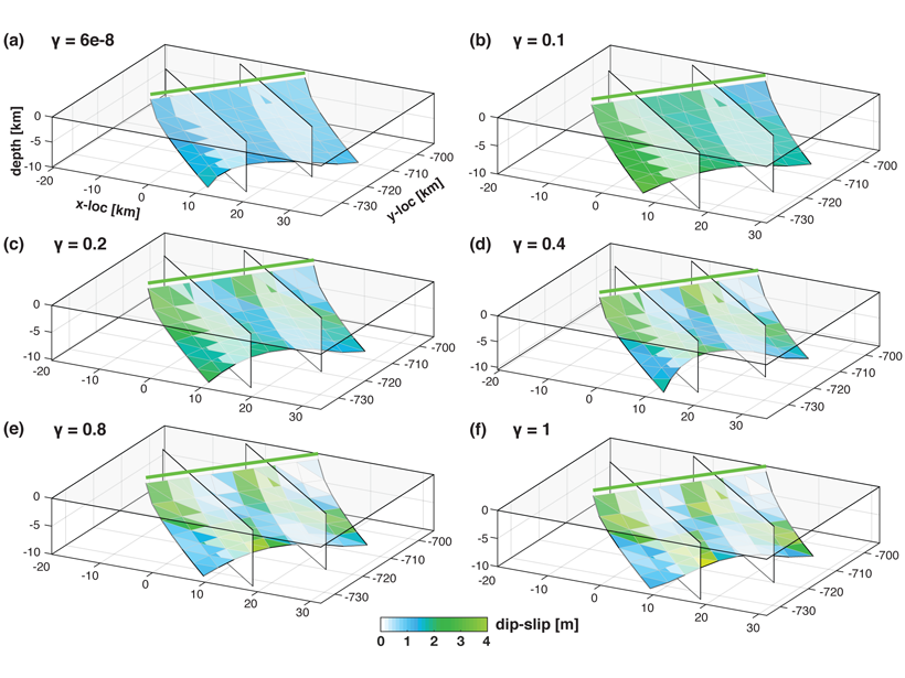
New Inversion Method Improves Earthquake Source Imaging

by Cécile Lasserre 30 August 20218 December 2022

A new method uses Bayesian inference to jointly invert for non-planar fault geometry and spatially variable slip (with associated uncertainties) in earthquake source modeling, based on geodetic data.

Viendo hacia afuera desde el Canion del Antílope Inferior, con el cielo cerca de la parte superior de la foto. La laminación característica de la arenisca es visible.
Posted inResearch Spotlights

La primera mirada de la meteorización a escala angstrom

Kate Wheeling, freelance science writer by Kate Wheeling 19 August 202124 February 2022

Investigadores observan cómo el vapor de agua y el líquido alteran las rocas sedimentarias a través de procesos físicos y químicos.

A view of Kīlauea’s summit lava lake
Posted inResearch Spotlights

Volcanic Tremor and Deformation at Kīlauea

Kate Wheeling, freelance science writer by Kate Wheeling 2 August 20216 March 2023

Two new studies investigate activity at Hawaii’s Kīlauea leading up to and following the 2018 eruption to better understand the volcano’s plumbing and behavior.

Sketch showing induced seismicity on critically stressed faults as a consequence of changes in pore pressure and related changes in stress due to anthropogenic activities
Posted inEditors' Vox

Understanding and Anticipating Induced Seismicity

by B. Müller, M.-L. Doan, T. H. Goebel, Yajing Liu, Patricia Martínez-Garzón, T. Mitchell and I. Zaliapin 30 July 20218 February 2023

A new special collection in JGR: Solid Earth and Earth and Space Science seeks papers from across disciplines that provide insights into induced seismicity at different spatial and temporal scales.

The Eagletail Mountains in southwestern Arizona
Posted inResearch Spotlights

Crustal Motion and Strain Rates in the Southern Basin and Range Province

Aaron Sidder, freelance science writer by Aaron Sidder 21 July 202119 October 2021

New research teases out variations in strain rates and explores potential earthquake hazards across the southern Basin and Range and Colorado Plateau.

The San Andreas Fault near Juniper Hills, Calif.
Posted inResearch Spotlights

A New Method Produces Improved Surface Strain Rate Maps

by Jack Lee 19 July 20215 December 2022

The transdimensional Bayesian approach handles GPS data limitations better than existing methods and may assist future seismic hazard assessment studies.

Two images comparing a high-resolution pore network in rock and a reconstruction of the same by the machine learning model.
Posted inEditors' Highlights

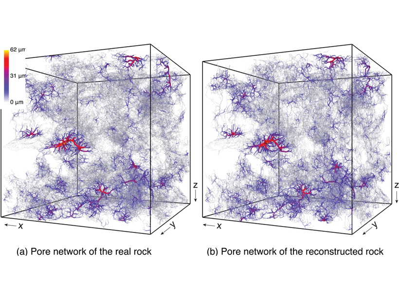
Reconstructing Rocks with Machine Learning

by D. O'Malley 12 July 20213 October 2022

Machine learning can be used to accurately reconstruct high-resolution, 3D images of rocks from 2D cross-sections, which opens the door to more detailed simulations.

Diagram showing high velocity slabs in the lower mantle beneath South America's present position and profile showing the westward motion of South America.
Posted inEditors' Highlights

Previous Intra-oceanic Subduction Found Beneath South America?

by M. Assumpção 9 July 202127 January 2023

Newly mapped fast velocity slabs in the lower mantle may be remnants of westward dipping intra-oceanic subduction, before flipping to the present eastward subduction beneath South America at 85 Ma.

Two plots comparing data fits for initial and recovered models.
Posted inEditors' Highlights

Improved Seismic Imaging Via Optimal Transport Theory

by Michael Bostock 7 July 202110 March 2022

Seismic waveform inversion is inherently non-linear. New objective functions based on optimal transport theory mitigate nonlinearity yielding stable solutions without need for accurate initial models.

Posts pagination

Newer posts 1 … 12 13 14 15 16 … 28 Older posts
Over a dark blue-green square appear the words Special Report: The State of the Science 1 Year On.

Features from AGU Publications

Research Spotlights

As Wildfires Increase in the West, So Does Suppression Spending

10 June 202610 June 2026
Editors' Highlights

Multi-Scale Fault Roughness Encapsulated in a Friction Law

11 June 202611 June 2026
Editors' Vox

Small-Scale Indian Ocean Dynamics Underpin Marine Ecology and Climate

4 June 20263 June 2026
Eos logo at left; AGU logo at right

About Eos
ENGAGE
Awards
Contact

Advertise
Submit
Career Center
Sitemap

© 2026 American Geophysical Union. All rights reserved Powered by Newspack