
Subsurface flow hydrology connects soils and bedrock lithology to long-term catchment evolution in humid landscapes.
landscape & topography

Posted inNews
Many of the World’s Cities Have Gotten Wetter
Dense populations, aerosols, and cities’ tendency to raise temperatures contribute to higher levels of precipitation in urban areas than surrounding rural areas.

Posted inScience Updates
Simulating Arctic Carbon Emissions in a Warming World
Not all climate models include carbon from thawing permafrost, and those that do often disagree. Scientists are working to better inform models and assess how these crucial materials are simulated.
Posted inEditors' Highlights
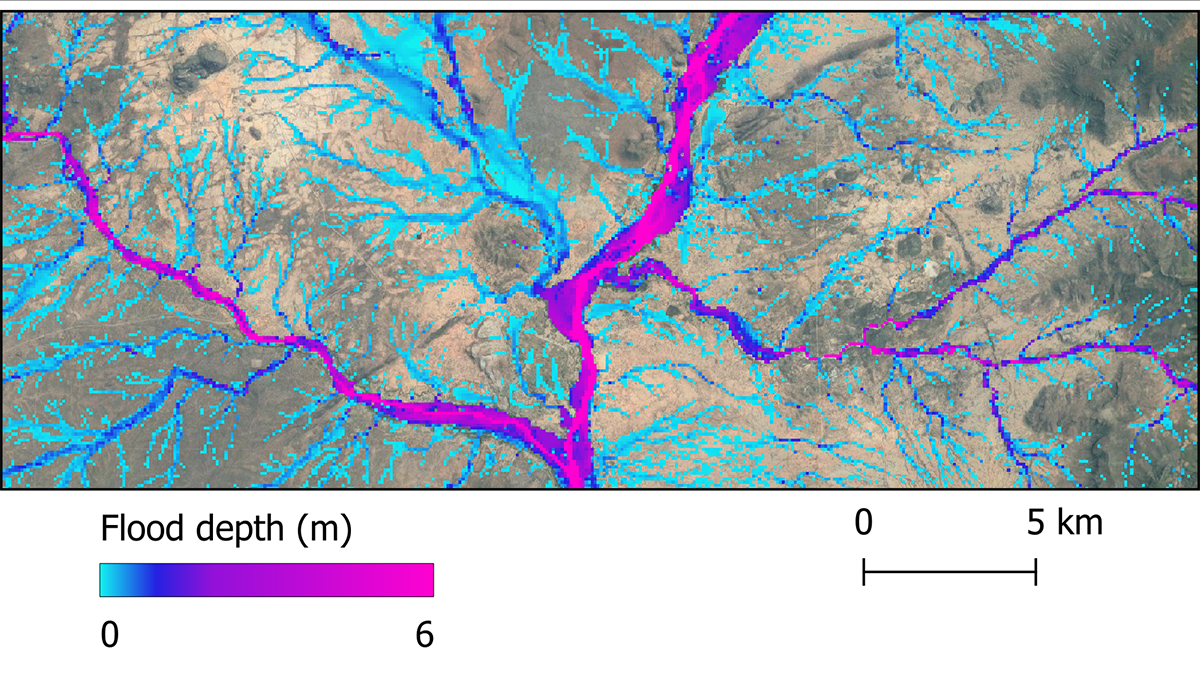
Future Global Flood Hazards at Unprecedented Accuracy
A global flood hazard map at 30-meter resolution is constructed using latest hydrology, topography, and climate data, and its accuracy is approaching that of local to regional scale flood inundation maps.
Posted inResearch Spotlights
Lithospheric Oddities May Be Sculpting Continental Interiors
Researchers propose a novel explanation for vertical motions of Earth’s surface far from active tectonic plate boundaries.

Posted inNews
The Surprising Factor Making the United States a Tornado Hot Spot
The roughness of terrain far upstream of where tornadoes occur can affect their formation. It could be what drives the contrast in tornado activity between North and South America.

Posted inResearch Spotlights
Cómo los movimientos del manto dan forma a la superficie terrestre
Dos nuevos conjuntos de datos ayudan a los investigadores a separar las influencias de la tectónica de placas y el movimiento del manto en la topografía de la superficie.
Posted inEditors' Vox
Harmonizing Theory and Data with Land Data Assimilation
Land data assimilation advances scientific understanding and serves as an engineering tool for land surface process studies, reflecting the trend of harmonizing theory and data in the big data era.

Posted inNews
As the Caspian Sea Recedes, Tectonics May Help Shape Its Coastline
Land subsidence and uplift determine where the Caspian Sea’s coastline shifts the fastest.
Posted inResearch Spotlights
How Mantle Movements Shape Earth’s Surface
Two new data sets help researchers tease apart the influences of plate tectonics and mantle movement on surface topography.