• About
  • Special Reports
  • Topics
    • Climate
    • Earth Science
    • Oceans
    • Space & Planets
    • Health & Ecosystems
    • Culture & Policy
    • Education & Careers
    • Opinions
  • Projects
    • Postcards From the Field
    • ENGAGE
    • Editors’ Highlights
    • Editors’ Vox
    • Eos en Español
    • Eos 简体中文版
    • Print Archive: 2015–2025
  • Policy Tracker
  • Blogs
    • Research & Developments
    • The Landslide Blog
  • Newsletter
  • Submit to Eos
  • AGU.org
  • Career Center
  • Join AGU
  • Give to AGU
  • About
  • Special Reports
  • Topics
    • Climate
    • Earth Science
    • Oceans
    • Space & Planets
    • Health & Ecosystems
    • Culture & Policy
    • Education & Careers
    • Opinions
  • Projects
    • Postcards From the Field
    • ENGAGE
    • Editors’ Highlights
    • Editors’ Vox
    • Eos en Español
    • Eos 简体中文版
    • Print Archive: 2015–2025
  • Policy Tracker
  • Blogs
    • Research & Developments
    • The Landslide Blog
  • Newsletter
  • Submit to Eos
Skip to content
  • AGU.org
  • Career Center
  • Join AGU
  • Give to AGU
Eos

Eos

Science News by AGU

Support Eos
Sign Up for Newsletter
  • About
  • Special Reports
  • Topics
    • Climate
    • Earth Science
    • Oceans
    • Space & Planets
    • Health & Ecosystems
    • Culture & Policy
    • Education & Careers
    • Opinions
  • Projects
    • Postcards From the Field
    • ENGAGE
    • Editors’ Highlights
    • Editors’ Vox
    • Eos en Español
    • Eos 简体中文版
    • Print Archive: 2015–2025
  • Policy Tracker
  • Blogs
    • Research & Developments
    • The Landslide Blog
  • Newsletter
  • Submit to Eos

landscape & topography

A collage of Martian valley networks superimposed with channels on Earth. The shapes of the channels appear to be almost identical.
Posted inNews

Martian Glaciers May Have Carved Its Valleys

Nola Taylor Redd, Science Writer by Nola Taylor Tillman 2 August 20222 August 2022

Networks of valleys provide puzzling hints of running water on the surface of the Red Planet. New research suggests that some tributaries could have formed from icy sheets thousands of meters thick.

San Pablo Bay marsh
Posted inResearch Spotlights

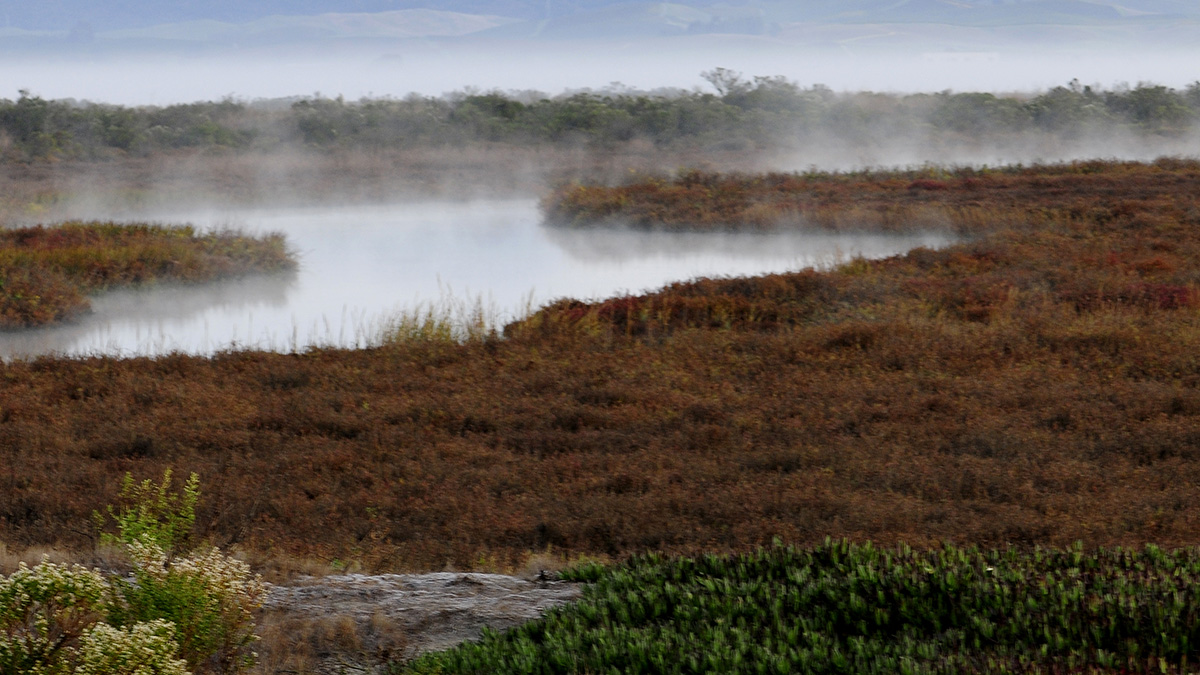
Atmospheric Rivers Help Coastal Wetlands Build Up Sediment

by Alexandra K. Scammell 13 July 202230 January 2024

Accounting for these storms and flooding can help experts predict and respond to rising sea levels.

Aerial view of the Pemali delta in Indonesia
Posted inNews

Why Do Rivers Jump Off the Beaten Path?

by Carolyn Wilke 21 June 2022

Researchers sifted through 50 years of satellite imagery and came up with new clues to where and why rivers avulse, suddenly changing their course.

A landscape with landslides along a steep mountain slope
Posted inResearch Spotlights

Steep Mountain Slopes Have Surprisingly Long Lifetimes

by Rebecca Dzombak 14 June 2022

New models of eastern Tibetan hillsides show that steep slopes with “excess” rock last longer on average than their shallower counterparts.

Cartoon illustrating the formation of depressed sedimentary basins and uplifted shoulder in continental rifts.
Posted inEditors' Highlights

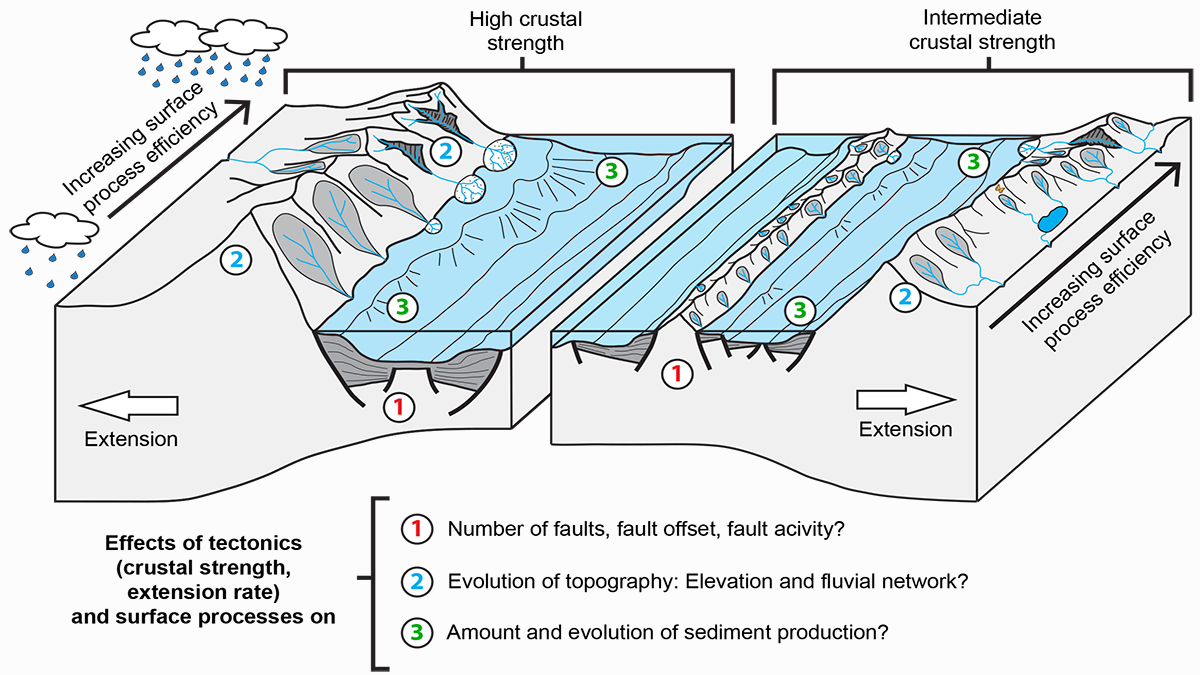
The Lost Topography Around Continental Rifts

by Fabio A. Capitanio 28 April 202228 October 2022

Numerical models provide quantitative constraints on topography lost to erosion, showing how the sediment influx in a sedimentary basin reflects its tectonic and topographic evolution.

Comparison of channels extracted from a high-resolution Digital Elevation Model using a traditional flow routing method and using the new method based on a Riverlab flow simulation (Elder Creek catchment, California, USA).
Posted inEditors' Highlights

Running Water on Topographic Data to Better Delineate Channels

by Mikaël Attal 25 April 202227 April 2022

Two-dimensional hydraulic simulations are a powerful tool to identify process domains such as channels, hillslopes, and floodplains in high-resolution topographic data.

Satellite image of the Mississippi River near Memphis, Tenn., with a false-color overlay
Posted inScience Updates

A Sharper Look at the World’s Rivers and Catchments

by Bernhard Lehner, Achim Roth, Martin Huber, Mira Anand and Michele Thieme 12 April 202210 March 2023

Digital hydrographic maps have transformed global environmental studies and resource management. A major database update will provide even clearer and more complete views of Earth’s waterways.

Maps of debris flow similarity index (DFSI) and the corresponding lengths of those debris flow channel segments.
Posted inEditors' Highlights

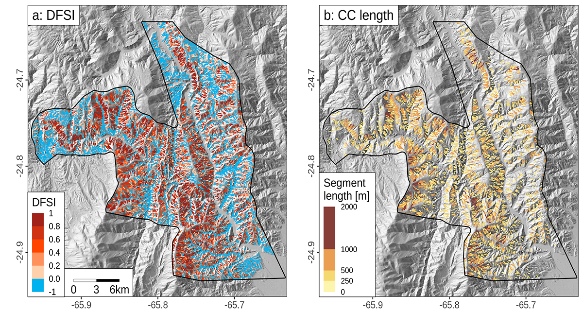
Debris Flows Keep the Landscape on the Straight and Narrow

by Adam Booth 6 April 20223 May 2022

New methods for identifying debris flow-shaped channels improve hazard quantification and highlight how high uplift rates and fractured bedrock facilitate debris flow-dominated landscape evolution.

Images showing sediment remobilized after the 2008 Wenchuan earthquake, China.
Posted inEditors' Highlights

Moving Earthquake-Generated Sediment Through a Landscape

by Amy E. East 30 March 202229 June 2022

Ten years after the Wenchuan earthquake, most of the new sediment it produced remained on the landscape, indicating a long recovery time.

Artist’s concept of the twin satellites in the GRACE program
Posted inResearch Spotlights

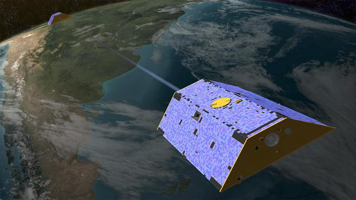
Fresh Approaches to Processing GRACE Data

Sarah Derouin, Science Writer by Sarah Derouin 24 March 202221 December 2022

Two studies showcase new methods for analyzing GRACE data that better match the land surface, producing clearer estimates of mass variations.

Posts pagination

Newer posts 1 … 5 6 7 8 9 … 14 Older posts
Over a dark blue-green square appear the words Special Report: The State of the Science 1 Year On.

Features from AGU Publications

Research Spotlights

Rocket Launches and Reentries Harm Earth’s Ozone Layer

8 June 20268 June 2026
Editors' Highlights

Pre-Existing Structure and Stress Shape Geothermal-Induced Seismicity

2 June 20261 June 2026
Editors' Vox

Small-Scale Indian Ocean Dynamics Underpin Marine Ecology and Climate

4 June 20263 June 2026
Eos logo at left; AGU logo at right

About Eos
ENGAGE
Awards
Contact

Advertise
Submit
Career Center
Sitemap

© 2026 American Geophysical Union. All rights reserved Powered by Newspack