Mount St. Helens, hidden away in a remote forest midway between Seattle, Wash., and Portland, Ore., had been putting out warning signals for 2 months. Still, the size and destruction of the 18 May 1980 eruption took the United States by surprise. The blast spewed ash into the air for more than 9 hours, and pyroclastic density currents and mudflows wiped out surrounding forests and downstream bridges and buildings. Fifty-seven people died as a result of the volcanic disaster, the worst known in the continental United States.
In addition to its immediate and devastating effects, the 1980 eruption spurred efforts to study volcanic processes and their impacts on surrounding landscapes more thoroughly and to advance monitoring and forecasting capabilities. It also prompted further cooperation among agencies and communities to better prepare for and respond to future volcanic eruptions.

According to a 2018 U.S. Geological Survey (USGS) report, there are 161 potentially active volcanoes in the United States and its territories, including 55 classified as high or very high threat [Ewert et al., 2018]. Over the past century, especially since 1980, integrated studies of active volcanic systems have shed light on magmatic and volcanic processes that control the initiation, duration, magnitude, and style of volcanic eruptions. However, because there have been few continuously monitored volcanic eruptions with observations that span the entire sequence before, during, and after eruption, our understanding of these processes and the hazards they pose is still limited.
This limited understanding, in turn, hampers efforts to forecast future eruptions and to help nearby communities prepare evacuation plans and to marshal and allocate resources during and after an event. Thus, a recent consensus study about volcanic eruptions by the National Academies of Sciences, Engineering, and Medicine [2017] highlighted the need to coordinate eruption responses among the broad volcanological and natural hazard scientific community as one of three grand challenges.
The charge of the Community Network for Volcanic Eruption Response (CONVERSE) is to maximize the scientific return from eruption responses at U.S. volcanoes.
The Community Network for Volcanic Eruption Response (CONVERSE) initiative, which began in 2018 as a 3-year Research Coordination Network supported by the National Science Foundation (NSF), is attempting to meet this challenge. The charge of CONVERSE is to maximize the scientific return from eruption responses at U.S. volcanoes by making the most efficient use possible of the relatively limited access and time to collect the most beneficial data and samples. This goal requires looking for ways to better organize the national volcano science community.
A critical component of this organization is to facilitate cooperation between scientists at academic institutions and the U.S. Geological Survey, which is responsible for volcano monitoring and hazard assessment at domestic volcanoes. Since 2019, CONVERSE has conducted several workshops to allow groups representing the various disciplines in volcanology to formulate specific science questions that can be addressed with data collected during an eruption response and assess their capacities for such a response. Most recently, in November 2020, we conducted a virtual response scenario exercise based on a hypothetical eruption of Mount Hood in the Oregon Cascades. A month later, Hawaii’s Kīlauea volcano erupted, allowing us to put what we learned from the simulation to use in a coordinated response.
A Virtual Eruption at Mount Hood
To work through a simulated response to an eruption scenario at Mount Hood, our CONVERSE team had planned an in-person meeting for March 2020 involving a 2-day tabletop exercise. Travel and meeting restrictions enacted in response to the COVID-19 pandemic required us to postpone the exercise until 16–17 November, when we conducted it virtually, with 80 scientists participating for one or more days. The goal of the exercise was to test the effectiveness of forming a science advisory committee (SAC) as a model for facilitating communications between responding USGS volcano observatories and the U.S. academic community.
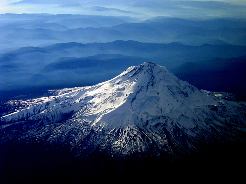
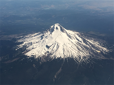
Mount Hood, located near Portland, Ore., is relatively accessible through a network of roads and would attract a lot of scientific interest during an eruption. Thus, we based our eruption scenario loosely on a scenario developed in 2010 for Mount Hood for a Volcanic Crisis Awareness training course.
Because a real-life eruption can happen at any time at any active volcano, participants in the November 2020 workshop were not informed of the selected volcano until 1 week prior to the workshop. Then we sent a simulated “exercise-only” USGS information statement to all registrants noting that an earthquake swarm had started several kilometers south of Mount Hood’s summit. In the days leading up to the workshop, we sent several additional information statements containing status updates and observations of the volcano’s behavior like those that might precede an actual eruption.
During the workshop, participants communicated via videoconference for large group discussions and smaller breakout meetings. We used a business communications platform to share graphics and information resources and for rapid-fire chat-based discussions.
The workshop started with an overview of Mount Hood’s eruptive history and monitoring status, after which the scenario continued with the volcano exhibiting escalating unrest and with concomitant changes in USGS alert level. Participants were asked to meet in groups representing different disciplines, including deformation, seismicity, gas, eruption dynamics, and geochemistry, to discuss science response priorities, particularly those that required access to the volcano.
This break in communication was done to mimic the difficulty that external scientists often encounter communicating with observatory staff during full-blown eruption responses.
As the simulated crisis escalated at the end of the first day of the workshop, non-USGS attendees were told they could no longer communicate with USGS participants (and vice versa). This break in communication was done to mimic the difficulty that external scientists often encounter communicating with observatory staff during full-blown eruption responses, when observatory staff are fully consumed by various aspects of responding to the eruption. Instead, scientific proposals had to be submitted to a rapidly formed Hood SAC (H-SAC) consisting of a USGS liaison and several non-USGS scientists with expertise on Mount Hood.
The H-SAC’s role was to quickly evaluate proposals submitted by discipline-specific groups on the basis of scientific merit or their benefit for hazard mitigation. For example, the geodesy group was approved to install five instruments at sites outside the near-field volcanic hazard zone to capture a deep deflation signal more clearly, an activity that did not require special access to restricted areas. On the other hand, a proposal by the gas group to climb up to the summit for direct gas sampling was declined because it was deemed too hazardous. Proposals by the tephra sampling group to collect ash at specific locations were also approved, but only if the group coordinated with a petrology group that had also submitted a proposal to collect samples for characterizing the pressure-temperature and storage conditions of the magma.
The H-SAC then provided recommendations to the Cascade Volcano Observatory (CVO) scientist-in-charge, with that discussion happening in front of all participants so they could understand the considerations that went into the decisionmaking. After the meeting, participants provided feedback that the SAC concept seemed to work well. The proposal evaluation process that included scientific merit, benefit for hazard mitigation, and feasibility was seen as a positive outcome of the exercise that would translate well into a real-world scenario. Participants emphasized, however, that it was critical that SAC members be perceived as neutral with respect to any disciplinary or institutional preferences and that the SAC have broad scientific representation.
Responding to Kīlauea’s Real Eruption
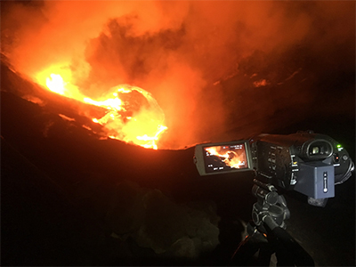
Just 1 month after the workshop, on 20 December 2020, Kīlauea volcano began erupting in real life, providing an immediate opportunity for CONVERSE to test the SAC model. The goals of CONVERSE with respect to the Kīlauea eruption were to facilitate communication and coordination of planned and ongoing scientific efforts by USGS scientists at the Hawaiian Volcano Observatory (HVO) and external scientists and to broaden participation by the academic community in the response.
These goals were addressed through two types of activities. First, a Kīlauea Scientific Advisory Committee (K-SAC), consisting of four academic and three USGS scientists, was convened within a week of the start of the eruption. This committee acted as the formal point of contact between HVO and the external scientific community for the Kīlauea eruption, and it solicited and managed proposals for work requiring coordination between these groups.
The K-SAC evaluated proposals on the basis of the potential for scientific gain and contributions to mitigating hazards. For example, one proposal dealt with assessing whether new magma had entered the chamber or whether the eruption released primarily older magma already under the volcano. The K-SAC also identified likely benefits and areas of collaboration between proposing groups, and it flagged potential safety and logistical (including permitting from the National Park Service) concerns in proposals as well as resources required from HVO.
Proposals recommended by the K-SAC were then passed to HVO staff, who consulted with USGS experts about feasibility, potential collaborations, and HVO resources required before making decisions on whether to move forward with them. One proposal supported by the K-SAC involved the use of hyperspectral imaging to quantify in real time the proportion of crystalline material and melt in the active lava lake to help determine the lava’s viscosity, a critical parameter for hazard assessment.
The second major activity of CONVERSE as the Kīlauea eruption progressed was to provide a forum for communication of science information open to all volcano scientists.
The second major activity of CONVERSE as the Kīlauea eruption progressed was to provide a forum for communication of science information via a business communications platform open to all volcano scientists. In addition, we posted information about planned and current activities by HVO and external scientists online and updated it using “living documents” as well as through virtual information sessions. As part of this effort, the K-SAC developed a simple spreadsheet that listed the types of measurements that were being made, the groups making these measurements, and where the obtained data could be accessed. For example, rock samples collected from the eruption were documented, and a corresponding protocol on how to request such samples for analytical work was developed. We held virtual town hall meetings, open to all, to discuss these topics, as well as updates from HVO K-SAC members on the status of the eruption and HVO efforts.
The Future of CONVERSE
The recent virtual exercise and the experience with the Kīlauea eruption provided valuable knowledge in support of CONVERSE’s mandate to develop protocols for coordinating scientific responses to volcanic eruptions. These two events brought home to us the importance of conducting regular, perhaps yearly or even more frequent, tabletop exercises. Such exercises could be held in person or virtually to further calibrate expectations and develop protocols for scientific coordination during real eruptions and to create community among scientists from different institutions and fields. Currently, workshops to conduct two scenario exercises are being planned for late this year and early next year. One will focus on testing deformation models with a virtual magma injection event; the other will focus on a response to an eruption occurring in a distributed volcanic field in the southwestern United States.
CONVERSE’s best practices and protocols could guide future international eruption responses coordinated among volcano monitoring agencies of multiple countries.
Future exercises should build on lessons learned from the Hood scenario workshop and the Kīlauea eruption response. For example, although the SAC concept worked well in principle, the process required significant investments of time that delayed some decisions, possibly limiting windows of opportunity for critical data collection at the onset of the eruption. Although CONVERSE is focused on coordination for U.S. eruptions, its best practices and protocols could guide future international eruption responses coordinated among volcano monitoring agencies of multiple countries.
A critical next step will be the development of a permanent organizational framework and infrastructure for CONVERSE, which at a minimum should include the following:
- A mechanism for interested scientists to self-identify and join CONVERSE so they can participate in eruption response planning and activities, including media and communications training.
- A national-level advisory committee with accessibility to equitable decisionmaking representation across scientific disciplines and career stages. The committee would be responsible for coordinating regular meetings, planning and conducting activities, liaising with efforts like the SZ4D and Modeling Collaboratory for Subduction initiatives, and convening eruption-specific SACs.
- Dedicated eruption SACs that facilitate open application processes for fieldwork efforts, including sample collection, distribution, and archiving. The SACs would establish and provide clear and consistent protocols for handling data and samples and would act as two-way liaisons between the USGS observatories and external scientists.
- A dedicated pool of rapid response instruments, including, for example, multispectral cameras, infrasound sensors, Global Navigation Satellite System receivers, uncrewed aerial vehicles, and gas measuring equipment. This pool could consist of permanent instruments belonging to CONVERSE and housed at an existing facility as well as scientist-owned distributed instruments available on demand as needed.
The SAC structure holds great promise for facilitating collaboration between U.S. observatories and external science communities during eruptions and for managing the many requests for information from scientists interested in working on an eruption. It also broadens participation in eruption responses beyond those who have preexisting points of contact with USGS observatory scientists by providing a point of contact and process to become engaged.
We are confident that when the next eruption occurs in the United States—whether it resembles the 1980 Mount St. Helens blast, the recent effusive lava flows from Kīlauea, or some other style—this structure will maximize the science that can be done during the unrest. Such efforts will ultimately help us to better understand what is happening at the volcano and to better assist communities to prepare for and respond to eruptions.
Acknowledgments
The CONVERSE RCN is funded by NSF grant 1830873. We thank all the participants of the Mount Hood Virtual Scenario Exercise and, specifically, the USGS CVO staff and the CONVERSE disciplinary leaders. We also thank USGS HVO staff for their insights and efforts during the ongoing Kīlauea eruption in making the K-SAC (and future SACs) a better vehicle for communication and collaboration. We thank Hawaii state volcanologist Bruce Houghton for developing the initial training course that served as a basis for the Mount Hood scenario workshop in collaboration with CVO scientists. Finally, we thank Tina Neal and Wes Thelen for their careful reviews of this paper. Any use of trade, firm, or product names is for descriptive purposes only and does not imply endorsement by the U.S. government.
References
Ewert, J. W., A. K. Diefenbach, and D. W. Ramsey (2018), 2018 update to the U.S. Geological Survey national volcanic threat assessment, U.S. Geol. Surv. Sci. Invest. Rep., 2018-5140, 40 pp., https://doi.org/10.3133/sir20185140.
National Academies of Sciences, Engineering, and Medicine (2017), Volcanic Eruptions and Their Repose, Unrest, Precursors, and Timing, Natl. Acad. Press, Washington, D.C., https://doi.org/10.17226/24650.
Author Information
Tobias P. Fischer ([email protected]), Department of Earth and Planetary Sciences, University of New Mexico, Albuquerque; Seth C. Moran, Cascades Volcano Observatory, U.S. Geological Survey, Vancouver, Wash.; Kari M. Cooper, Department of Earth and Planetary Sciences, University of California, Davis; Diana C. Roman, Earth and Planets Laboratory, Carnegie Institution for Science, Washington, D.C.; and Peter C. LaFemina, Department of Geosciences, Pennsylvania State University, University Park
Citation:
Fischer, T. P., S. C. Moran, K. M. Cooper, D. C. Roman, and P. C. LaFemina (2021), Making the most of volcanic eruption responses, Eos, 102, https://doi.org/10.1029/2021EO162790. Published on 31 August 2021.
Text © 2021. The authors. CC BY-NC-ND 3.0
Except where otherwise noted, images are subject to copyright. Any reuse without express permission from the copyright owner is prohibited.