
Rivers are the arteries of the planet, providing vital resources as they flow and pulse across landscapes in a vast global network. Rivers and streams convey sediments and nutrients to fertile valleys and river deltas, create habitat corridors and transportation routes, and deliver life-sustaining fresh water to aquatic and riparian ecosystems and to human populations.
Runoff that collects in headwaters drains into small mountain streams and ultimately accumulates into mighty lowland rivers that discharge into the world’s oceans. Along their paths, waterways both influence and are influenced by the landscapes and ecosystems they traverse. Understanding and managing surface water resources therefore require fundamental hydrographic knowledge and monitoring as well as the tools that support mapping and analysis of natural river and drainage characteristics. These characteristics include conditions of climate, landforms, and soils, as well as anthropogenic influences such as water abstractions, pollution, and river fragmentation.
Studies of global and regional freshwater landscapes, and of the status and management of the resources they provide, have progressed profoundly in recent years. Many advancements have been facilitated by the increased availability and accuracy of novel remote sensing imagery and the sophisticated interpretation of these data. A particularly important prerequisite for many water-related assessments and modeling efforts is digital representations of rivers and catchments.
In the absence of a universally accepted digital global river network, the HydroSHEDS database [Lehner et al., 2008] has emerged in the past decade as the most frequently applied global hydrographic mapping product [Lindersson et al., 2020], supporting a large and growing community of users. Soon this community will have access to a new version of HydroSHEDS offering expanded capabilities and promising clearer views of Earth’s arteries.
Global Data for Freshwater Modeling
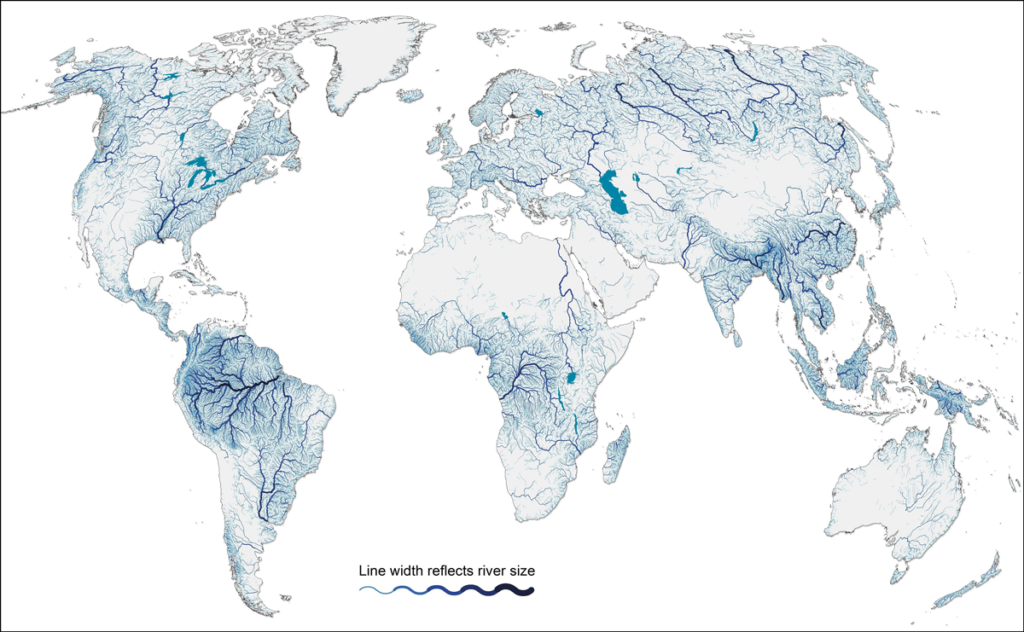
Digital hydrographic maps organize information about freshwater landscapes, including rivers (Figure 1), catchments (the land area that drains into a given point in the river network), lakes, and wetlands, into manageable geospatial units. By doing so, they also provide connections between units to allow for upstream and downstream analyses within drainage networks.
River and catchment maps are often derived from gridded digital elevation models (DEMs) by tracing river channels and catchment divides, assuming that the path of water follows topography along lines of steepest descent. The resulting delineations of flow directions, river courses, and catchment boundaries form the foundation of most hydrological models and enable the visualization, analysis, and management of associated river and catchment information.
Given its high and modifiable spatial resolution, applications that make use of the HydroSHEDS database span scales from small catchments to large river basins and the entire globe.
Since its introduction in 2008, the HydroSHEDS database has transformed large-scale hydroecological research and applications worldwide. Given its high and modifiable spatial resolution, applications that make use of the HydroSHEDS database span a multitude of scales, from small catchments to large river basins and the entire globe.
HydroSHEDS forms an integral part of many regional or global hydrological and climate change models. It has informed or enabled novel studies and assessments of global biogeochemical cycles and sediment transport from land to the oceans, the dissemination of chemical contaminants and pollution along the global river network, the status of global free-flowing rivers, and patterns of aquatic species ranges and global freshwater biodiversity.
Beyond scientific research, the standardized river network and catchment delineations in HydroSHEDS offer a geospatial framework that serves many management and decisionmaking applications. For example, HydroSHEDS data have been used to support efforts to safeguard societally beneficial aquatic ecosystem services such as water provision and flood control, to assess human health impacts from degrading water quality, to inform conservation planning efforts, and to find strategic solutions at the nexus of water, food, energy, and the environment.
The data are used by nongovernmental organizations and national and international institutions to organize and report global water information, including in relation to some of the United Nations’ Sustainable Development Goals for water and sanitation. Finally, the data appear in countless online applications for education, community science, and public policy because of the simplicity of mapping and visualizing them in geographic information systems (GIS).
Setting the Standard for Global Hydrography
The first version of HydroSHEDS, which is still in use, was derived from the DEM of NASA’s Shuttle Radar Topography Mission (SRTM) at a pixel resolution of 3 arc seconds (roughly 90 meters at the equator). In addition to automatic derivation algorithms, extensive manual inspections and corrections were applied during the creation of HydroSHEDS to ensure a high degree of quality control. Resulting HydroSHEDS products are available at varying resolutions, ranging from 3 arc seconds to 5 arc minutes (roughly 10 kilometers at the equator). Catchment information is offered in nested subbasin structures, making the tool uniquely suitable for applications at scales ranging from individual river basins to countries or the entire world.
The integration of a suite of related data collections and value-added information continues to expand the HydroSHEDS family of products.
Given its wide acceptance as a free and easy-to-use database, HydroSHEDS grew to establish a common standard in hydrographic spatial units (i.e., studies performed using HydroSHEDS all use the same catchment boundaries or river reach units defined therein). Many researchers and users have produced their own data and results, such as on aquatic species distributions, that are interoperable with these standardized units, adding to HydroSHEDS’ versatility. Further, the integration of a suite of related data collections and value-added information continues to expand the HydroSHEDS family of products. Foremost among these is the HydroATLAS compilation of more than 50 hydro-environmental attributes for each of about 8 million river reaches and about 1 million subbasins [Linke et al., 2019].
Amid its remarkable success, however, version 1 of HydroSHEDS has important limitations. In particular, coverage above 60°N latitude (a region largely within the Arctic Circle) is missing from the 3-arc-second product. For coarser products, coverage of this region is of low quality because no underpinning SRTM elevation data were available. Similarly, when version 1 of HydroSHEDS was created, some areas, such as very steep or glaciated mountain terrain, could not be fully resolved because of inherent data gaps or other errors.
Similar global hydrographic maps have been developed to improve on these limitations, such as the MERIT Hydro data set [Yamazaki et al., 2019]. However, these products have different technical specifications, including differing coastlines and the absence of a nested catchment breakdown. Thus, they are not directly compatible with the existing HydroSHEDS suite of data layers, making updates and transfers of ongoing projects difficult for users.
HydroSHEDS Sharpens Its Vision
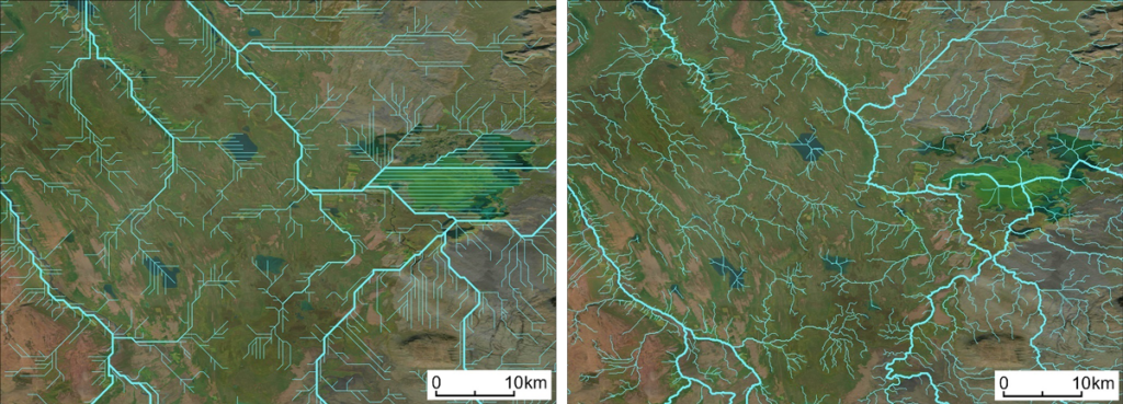
HydroSHEDS version 2 (also called HydroSHEDS-X), currently under development (Figure 2), will offer substantial revisions and improvements on version 1 while following the same design characteristics to ensure maximum compatibility between versions and to related products.
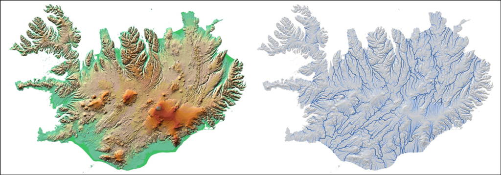
The new version is derived from the TanDEM-X (TerraSAR-X add-on for digital elevation measurement) global elevation model, which was created in partnership between the German Aerospace Center (DLR) and Airbus, and is superior to the SRTM DEM in several ways. The elevation data of TanDEM-X were produced at an original resolution of 12 meters, and they cover the entire global land surface area, including northern latitudes. Global TanDEM-X data at 90-meter pixel resolution—and at 30-meter pixel resolution for regions not currently affected by political conflict—were recently licensed for free distribution.
This approach ensures fully global, homogeneous coverage, including of areas above 60°N latitude, at substantially improved quality.
To enhance the quality of results while retaining spatial compatibility, HydroSHEDS-X has been created from the original, nonpublic 12-meter-resolution version of TanDEM-X, yet it will be released at the same 3-arc-second resolution as HydroSHEDS version 1. This approach ensures fully global, homogeneous coverage, including of areas above 60°N latitude, at substantially improved quality due to both the finer resolution of the underpinning DEM and the reduced need to fill data gaps compared with the SRTM data.
To produce HydroSHEDS-X, the original 12-meter TanDEM-X data are being preprocessed and corrected at 3-arc-second resolution with an open water mask and with novel DLR-provided vegetation and settlement maps (e.g., 3D World Settlement Footprint). These corrections are applied to reduce distortions in elevation caused by vegetation cover, such as in dense forests in riparian areas, and by human-made structures in built-up areas.
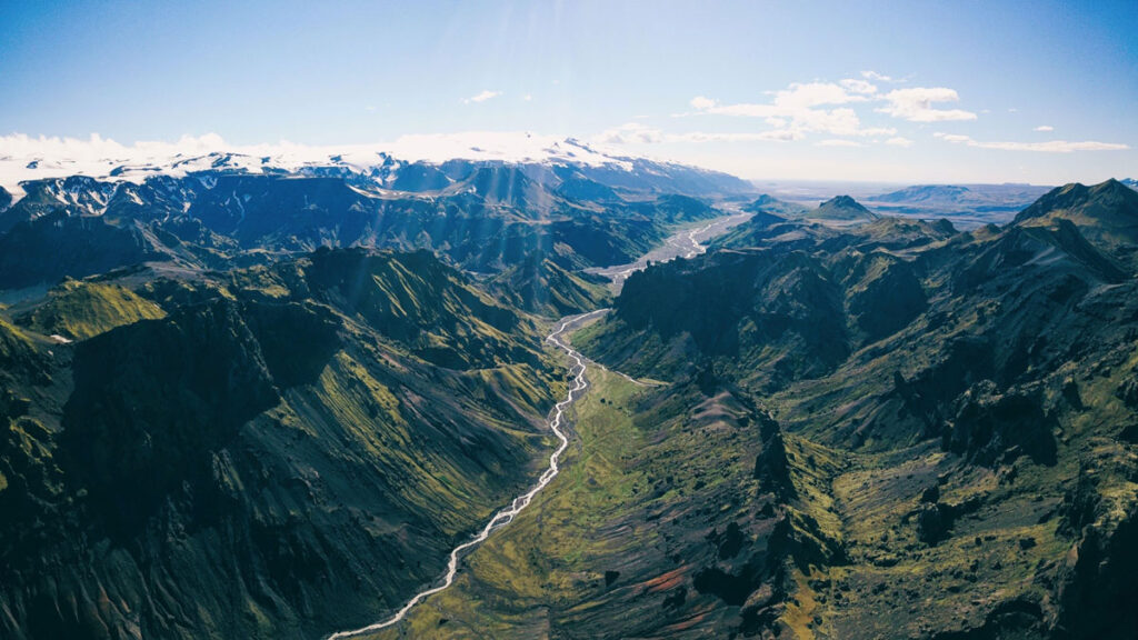
Following these preprocessing steps, refined hydrological optimization and correction algorithms are applied to derive the drainage pathways. These procedures include improved “stream-burning” techniques that reconcile topographic and hydrographic data to ensure that calculated drainage patterns conform to those observed in the field. The stream-burning techniques incorporate recent auxiliary data products, such as high-resolution terrestrial open water masks, which improve the tracing of drainage pathways as centerlines in wide river channels and inside large lakes (Figure 3).
In a subsequent processing step, the 3-arc-second river network is then upscaled into coarser-resolution versions (such as 15 arc seconds and 5 arc minutes) for use in global hydrological models. As a hallmark feature, the creation of HydroSHEDS-X is being guided by a high level of manual quality control, including comparisons and alignment with remote sensing imagery and existing regional or local river maps.
Enabling Next-Generation Applications
The main release of the new HydroSHEDS-X database under a free license is scheduled to start this year, with regions above 60°N latitude being completed first (see the HydroSHEDS website for more details).
An important part of the development of HydroSHEDS-X is facilitating the transition of companion data products to be used with the new version. In particular, products such as HydroATLAS will be re-created using HydroSHEDS-X, and information about these transitions—such as tables linking new and old identification numbers of subbasins and river reaches—will be produced so that users can walk their data over to the new format.
We envision the updated version of HydroSHEDS becoming a foundational open data framework that will enable global and regional applications in hydro-environmental research and freshwater resource management.
Given the longevity and consistency of the original HydroSHEDS product, we envision the updated version becoming a foundational open data framework that will enable the next generation of global and regional applications in hydro-environmental research and freshwater resource management.
In particular, we expect the extended coverage of HydroSHEDS-X beyond 60°N latitude to promote novel assessments of climate change implications in Arctic aquatic environments. Also, the improved underpinning elevation data and the resulting overall accuracy enhancements offer new opportunities of high-resolution global applications. For example, HydroSHEDS-X can facilitate a coupling of hydrologic models with real-time remote sensing imagery that allows for monitoring of water availability, water shortages, or flood risk at unprecedented spatial and temporal resolutions worldwide. With its new capabilities, HydroSHEDS-X aims to advance our efforts to tackle pressing questions about the future of Earth’s terrestrial landscape and the arteries that carry vital resources through it.
Acknowledgments
We acknowledge The Nature Conservancy for providing additional funding for this research beyond that provided by the authors’ affiliated organizations.
References
Lehner, B., K. Verdin, and A. Jarvis (2008), New global hydrography derived from spaceborne elevation data, Eos Trans. AGU, 89(10), 93–94, https://doi.org/10.1029/2008EO100001.
Lindersson, S., et al. (2020), A review of freely accessible global datasets for the study of floods, droughts and their interactions with human societies, WIREs Water, 7(3), e1424, https://doi.org/10.1002/wat2.1424.
Linke, S., et al. (2019), Global hydro-environmental sub-basin and river reach characteristics at high spatial resolution, Sci. Data, 6, 283, https://doi.org/10.1038/s41597-019-0300-6.
Yamazaki, D., et al. (2019), MERIT Hydro: A high-resolution global hydrography map based on latest topography dataset, Water Resour. Res., 55(6), 5,053–5,073, https://doi.org/10.1029/2019WR024873.
Author Information
Bernhard Lehner ([email protected]), Department of Geography, McGill University, Montreal, Que., Canada; also at Confluvio Consulting Inc., Montreal, Que., Canada; Achim Roth and Martin Huber, German Aerospace Center (DLR), Oberpfaffenhofen; Mira Anand, Confluvio Consulting Inc., Montreal, Que., Canada; and Michele Thieme, World Wildlife Fund, Washington, D.C.