• About
  • Sections
  • Topics
    • Climate
    • Earth Science
    • Oceans
    • Space & Planets
    • Health & Ecosystems
    • Culture & Policy
    • Education & Careers
    • Opinions
  • Projects
    • ENGAGE
    • Editors’ Highlights
    • Editors’ Vox
    • Eos en Español
    • Eos 简体中文版
    • Print Archive
  • Blogs
    • Research & Developments
    • The Landslide Blog
  • Newsletter
  • Submit to Eos
  • AGU.org
  • Career Center
  • Join AGU
  • Give to AGU
  • About
  • Sections
  • Topics
    • Climate
    • Earth Science
    • Oceans
    • Space & Planets
    • Health & Ecosystems
    • Culture & Policy
    • Education & Careers
    • Opinions
  • Projects
    • ENGAGE
    • Editors’ Highlights
    • Editors’ Vox
    • Eos en Español
    • Eos 简体中文版
    • Print Archive
  • Blogs
    • Research & Developments
    • The Landslide Blog
  • Newsletter
  • Submit to Eos
Skip to content
  • AGU.org
  • Career Center
  • Join AGU
  • Give to AGU
Eos

Eos

Science News by AGU

Support Eos
Sign Up for Newsletter
  • About
  • Sections
  • Topics
    • Climate
    • Earth Science
    • Oceans
    • Space & Planets
    • Health & Ecosystems
    • Culture & Policy
    • Education & Careers
    • Opinions
  • Projects
    • ENGAGE
    • Editors’ Highlights
    • Editors’ Vox
    • Eos en Español
    • Eos 简体中文版
    • Print Archive
  • Blogs
    • Research & Developments
    • The Landslide Blog
  • Newsletter
  • Submit to Eos

navigation

Graph showing range of water levels in the Great Lakes and the potential benefit from risk management strategies including insurance and dredging
Posted inEditors' Highlights

New Analysis Helps Manage Risks to Shipping in the Great Lakes

by Jim Hall 11 May 202018 October 2022

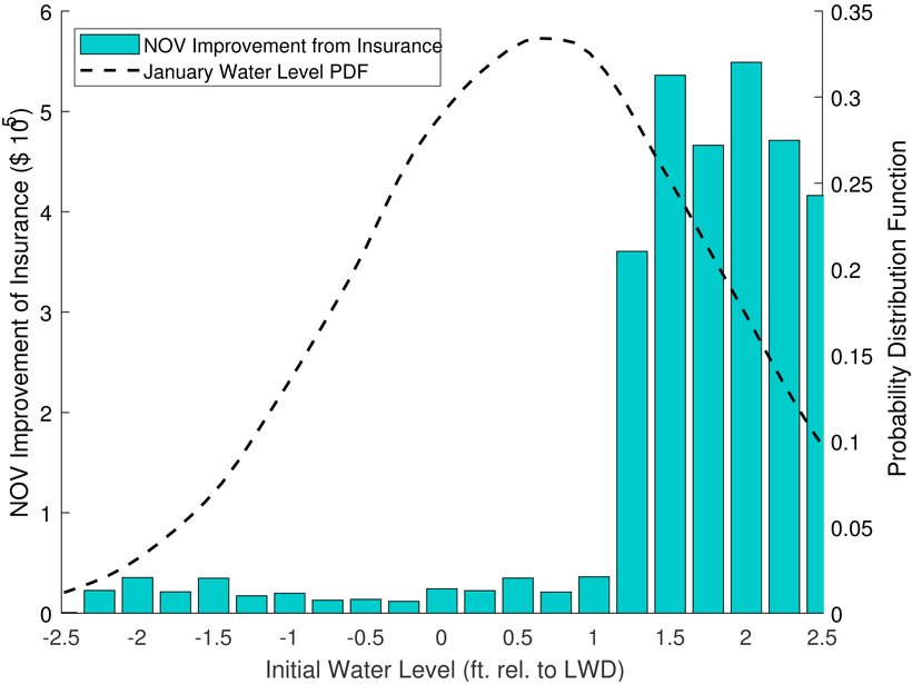
Modeling of mysteriously fluctuating water levels in the Great Lakes has helped to optimize the prices of shipping insurance contracts along with investments in dredging navigation channels.

Profile of a shrimp against a black background
Posted inNews

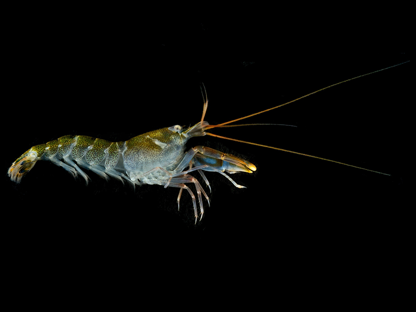
Snapping Shrimp Pump Up the Volume in Warmer Water

Katherine Kornei, Science Writer by Katherine Kornei 10 March 202025 March 2024

As the ocean warms because of climate change, the louder din could mask other marine animals’ calls used to navigate, forage, and find mates.

Scientist in a hard hat with a rover in an underground mine
Posted inFeatures

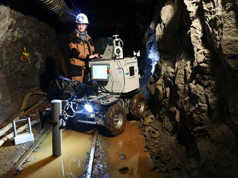
Underground Robots: How Robotics Is Changing the Mining Industry

Adityarup Chakravorty, freelance science writer by Adityarup Chakravorty 13 May 201928 July 2022

From exploring flooded sites to providing alerts, use of robotics aims to “increase the arsenal of tools that can help miners work more safely and efficiently.”

Traditional Polynesian navigators steer by stars close to the horizon for a more precise reckoning.
Posted inNews

Stars and Swells Guide a Polynesian Canoe Around the World

by E. Deatrick 22 June 201619 July 2022

Modern oceanographers and ancient navigators rely on similar waves to study the world's oceans.

Posted inNews

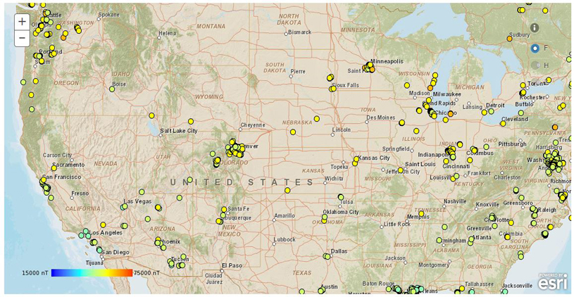
Smartphone App Seeks to Make Navigation Safer

by L. O’Hanlon 6 January 20155 May 2022

The app sends local magnetic field strength along with your phone’s position and orientation to scientists, who use the data to fine-tune magnetic field models.

Posts pagination

Newer posts 1 2
A view of a Washington, D.C., skyline from the Potomac River at night. The Lincoln Memorial (at left) and the Washington Monument (at right) are lit against a purple sky. Over the water of the Potomac appear the text “#AGU24 coverage from Eos.”

Features from AGU Publications

Research Spotlights

What’s Changed—and What Hasn’t—Since the EPA’s Endangerment Finding

24 June 202524 June 2025
Editors' Highlights

Shedding Light on the Mysteries of Deep Earthquakes

26 June 202526 June 2025
Editors' Vox

Water Tracks: The Veins of Thawing Landscapes

25 June 202525 June 2025
Eos logo at left; AGU logo at right

About Eos
ENGAGE
Awards
Contact

Advertise
Submit
Career Center
Sitemap

© 2025 American Geophysical Union. All rights reserved Powered by Newspack