
A new method for examining the tiny vibrations of Earth caused by ocean swells could help reveal details of deep-Earth structure.
surface waves & tides

Posted inEditors' Vox
Unlocking the Secrets of Floods: Breakthroughs in Riverine and Coastal Modeling
To enhance flood modeling, it is imperative to gain a comprehensive understanding of the causative mechanisms and cutting-edge models and tools, while also acknowledging their uncertainties.

Posted inENGAGE, News
Spain’s Seafaring Sports See Fewer Calm Days
Knowing the best days for calm or active water activities can strengthen the local economy and help tourists optimize their trips.

Posted inEditors' Highlights
Rotation of Europa’s Icy Shell Driven by Deep Ocean Currents
A model using currents in the deep ocean to drive rotation of Europa’s ice shell from below can explain why its surface may drift despite being tidally locked.
Posted inEditors' Highlights
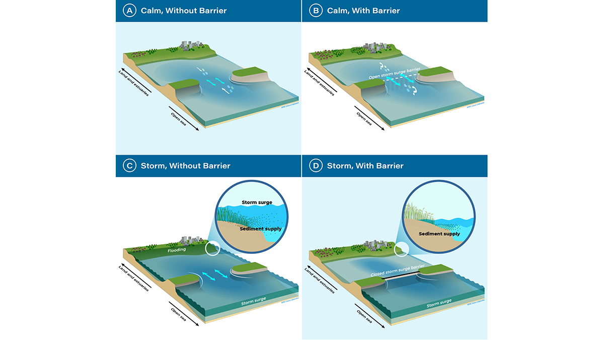
A Turning Point for Estuaries Worldwide
As estuarine barriers are built in response to sea level rise, flooding, and salinization, more research is needed to better understand their implications for human activities and ecosystems.
Posted inEditors' Highlights
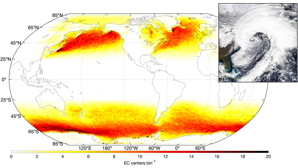
Tracking Ocean Waves from Extratropical Cyclones on Global Scale
A new way of tracking ocean waves with satellite measurements was developed and applied to extratropical cyclones, revealing the effects of storm characteristics on extreme sea states.

Posted inNews
El derretimiento del hielo marino del océano Ártico potencia las mareas
Si el cambio climático anula el ciclo estacional de hielo y deshielo, se desencadenaría un ciclo de retroalimentación de derretimiento del hielo marino en algunas partes del Ártico canadiense.

Posted inEditors' Highlights
Accurate Ocean Tides for Earth System Models
Accurate tide models require self-attraction and loading terms, but can this calculation be done accurately and efficiently for use in global tide and Earth system models?

Posted inEditors' Highlights
Can Anelastic Attenuation of Oceanic Mantle be Reliably Measured?
A new study demonstrates that robust anelastic attenuation measurements can be made across ocean bottom seismic arrays at different locations using surface wave array analysis.
Posted inEditors' Highlights
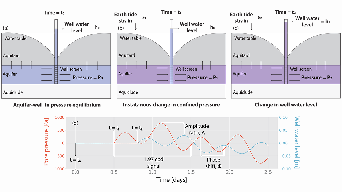
Modeling Groundwater Responses to Earth Tides
Tidal fluctuations in water well levels can reveal characteristics of the subsurface, and a new model based on coupled physics delineates the limitations of inherently simplistic analytical solutions.