
The Landslide Blog is written by Dave Petley, who is widely recognized as a world leader in the study and management of landslides.

In 1650, a destructive tsunami occurred in the Aegean Sea, which is an embayment of the Mediterranean sea, located between the modern Greece to the west and Turkey to the east. There is a nice presentation about the tsunami and its effects online. It is documented that the tsunami destroyed farmland, boats, trees and churches on the island of Santorini. There is clear archaeological and geological evidence for this tsunami.
The source of the tsunami is known to be an underwater volcano, known as Kolumbo, located about 7 km northeast of Santorini. The volcano was erupting for several weeks ahead of the tsunami. On the 29 September 1650, a huge explosion was heard up to 100 km from Santorini as the volcano erupted catastrophically. The resultant tsunami waves were up to 20 m high, striking islands across the southern part of the Aegean Sea, as well as the north coast of Crete.
It has long been speculated that the trigger for the catastrophic eruption might have been the collapse of the volcanic cone triggered by a submarine landslide. This hypothesis has been investigated by a team that has just published their research in the journal Nature Communications (Karstens et al. 2023 – available open access). The researchers have mapped Kolumbo with 3D seismics, generating profiles of the crater and the surrounding seabed.
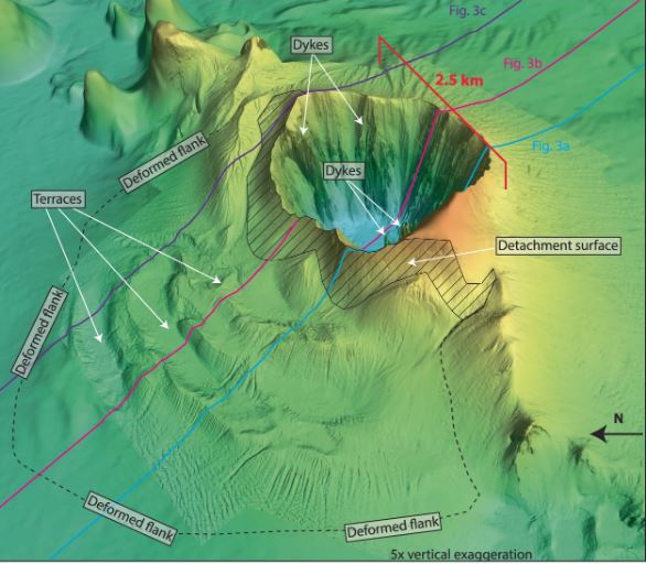
The paper includes the following perspective view of the bathymetry data, showing the crater, the landslide deposit and the clear detachment surface – the shear surface in landslide parlance:-
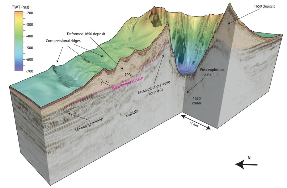
The seismic profile through the hypothesised landslide deposit clearly demonstrates that thus was a flank collapse event:-
Thus, the sequence of events was that during the eruption, the flanks of the volcano destabilised and slipped in a very large landslide – the estimated volume is 1.2 cubic kilometres. This then removed the cap from the magma chamber, which contained a large volume of gas under pressure. This generated a huge explosion that created the crater that is seen in the images above. The crater is 2.5 km in diameter and 500 m deep.
The team has modelled the tsunami that would result from a landslide event of this sequence of events – a flank collapse followed by an explosives’ eruption – and have compared it with the modelled tsunami from an explosion alone. They found that the former sequence fits the observed tsunami rather better.
It is interesting that in recent weeks we have seen a large GLOF that was triggered by slope instability into the glacial lake and now clear evidence that a volcanic eruption and tsunami were caused by a landslide. I have long argued that slope instability is under-appreciated as the trigger mechanism for major hazards across a broad range of types.
Reference
Jens Karstens, Gareth J. Crutchley, Thor H. Hansteen, Jonas Preine, Steven Carey, Judith Elger, Michel Kühn, Paraskevi Nomikou, Florian Schmid, Giacomo Dalla Valle, Karim Kelfoun, Christian Berndt. 2023. Cascading events during the 1650 tsunamigenic eruption of Kolumbo volcano. Nature Communications, 14 (1) DOI: 10.1038/s41467-023-42261-y