
The Landslide Blog is written by Dave Petley, who is widely recognized as a world leader in the study and management of landslides.

The Federal Office of Topography in Switzerland has collected and published online aerial imagery of the site of the deadly 21 June 2024 debris flow in Switzerland, which killed three people. The imagery includes very high quality vertical aerial photography together with a large number of oblique images of the topography. The pictures can be accessed via a viewing tool, which includes the ability to compare before and after images. It is a stunning example of the application of modern technology.
You should be able to view this tool, and the imagery, below (or try this link – WordPress is a little unpredictable in how it handles these type of tools, so refresh if the link doesn’t work immediately), hopefully including an initial perspective that shows the main channel down which the debris flow travelled on the right side, and a major tributary running from the west to the east across the main part of the image:-
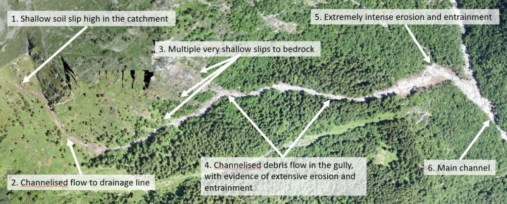
In trying to understand what occurred in the very steep catchment above the houses, I suspect that attention will focus on this channel. I have roughly annotated a few key features of this post-event image below. I should add here that this is speculative – the site will be investigated properly by others, which will provide the definitive analysis of the chain of events, and I bow to these analyses.
There is also a good oblique image of the upper part of this catchment (this is a very large file, so downloads slowly), which is a good reminder of the steepness of the topography.
My initial interpretation of the potential events is as follows:
- There is evidence of a shallow soil / regolith failure at the head of the catchment (also shown in the oblique image), which probably kicked off the disaster chain.
- There is a debris trail from the shallow failure to the main channel, with evidence of erosion and entrainment. This is similar to the series of events that often leads to channelised debris flows in Hong Kong.
- There is also evidence of multiple shallow landslides on the flanks of the gulley, which appear to have involved very shallow slips of weathered material and vegetation down to bedrock.
- A debris channelised debris flow has travelled down the channel. The initial failure in 1 appears to have provided enough material and water that this has eroded and entrained material from the channel, thus growing in scale rapidly, with contributions from the shallow slips referenced in 3.
- Towards the foot of this channel, and extremely intense erosive event has occurred – this could be classed as a landslide in its own right? – such that a very large volume of material joined the main channel.
- Once in the main channel, the debris flow continued to entrain and erode, striking the houses. There are probable contributions from other channels too.
This series of events highlights the hazards in very steep channels during extremely heavy rainfall. In Japan and Hong Kong, such natural terrain landslides tend to be mitigated with flexible and rigid barriers that are designed to catch the debris.