• About
  • Sections
  • Topics
    • Climate
    • Earth Science
    • Oceans
    • Space & Planets
    • Health & Ecosystems
    • Culture & Policy
    • Education & Careers
    • Opinions
  • Projects
    • ENGAGE
    • Editors’ Highlights
    • Editors’ Vox
    • Eos en Español
    • Eos 简体中文版
    • Print Archive
  • Blogs
    • Research & Developments
    • The Landslide Blog
  • Newsletter
  • Submit to Eos
  • AGU.org
  • Career Center
  • Join AGU
  • Give to AGU
  • About
  • Sections
  • Topics
    • Climate
    • Earth Science
    • Oceans
    • Space & Planets
    • Health & Ecosystems
    • Culture & Policy
    • Education & Careers
    • Opinions
  • Projects
    • ENGAGE
    • Editors’ Highlights
    • Editors’ Vox
    • Eos en Español
    • Eos 简体中文版
    • Print Archive
  • Blogs
    • Research & Developments
    • The Landslide Blog
  • Newsletter
  • Submit to Eos
Skip to content
  • AGU.org
  • Career Center
  • Join AGU
  • Give to AGU
Eos

Eos

Science News by AGU

Support Eos
Sign Up for Newsletter
  • About
  • Sections
  • Topics
    • Climate
    • Earth Science
    • Oceans
    • Space & Planets
    • Health & Ecosystems
    • Culture & Policy
    • Education & Careers
    • Opinions
  • Projects
    • ENGAGE
    • Editors’ Highlights
    • Editors’ Vox
    • Eos en Español
    • Eos 简体中文版
    • Print Archive
  • Blogs
    • Research & Developments
    • The Landslide Blog
  • Newsletter
  • Submit to Eos

Editors’ Highlights

Two figures from the paper that show wave measurements in the presence of sea ice using satellite remote sensing.
Posted inEditors' Highlights

Satellites Remotely Measure Ocean Waves and Sea Ice Interactions

by Ryan P. Mulligan 12 July 202228 September 2022

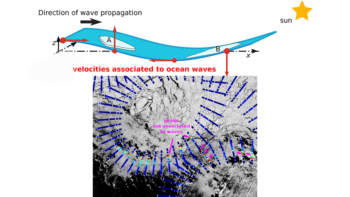
A new method for using satellite observations from multiple sensors improves measurements of ocean waves as they propagate through and interact with sea ice.

Map showing the global distribution of surface-mixed layer depth.
Posted inEditors' Highlights

An Ocean Surface Layer with Potential

by Lars Umlauf 11 July 202217 August 2022

The depth of the ocean’s surface mixed layer is typically defined based on density thresholds. However, a more physically appealing definition can be constructed from potential energy considerations.

A map of central Mexico that uses different colors to show variations of arsenic concentrations in groundwater.
Posted inEditors' Highlights

Protecting Children’s Health Can Benefit the Economy

by Avner Vengosh 6 July 202228 February 2023

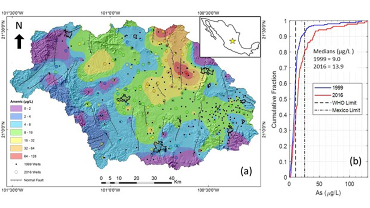
A new study presents an integrated approach to predicting the human health impacts, economic implications, and remediation solutions for using contaminated groundwater in Central Mexico.

Four graphs showing the percent area covered by atmospheric rivers in the northern and southern hemispheres.
Posted inEditors' Highlights

Comparing Methods for Analysis of Atmospheric Rivers

by Minghua Zhang 4 July 202230 January 2024

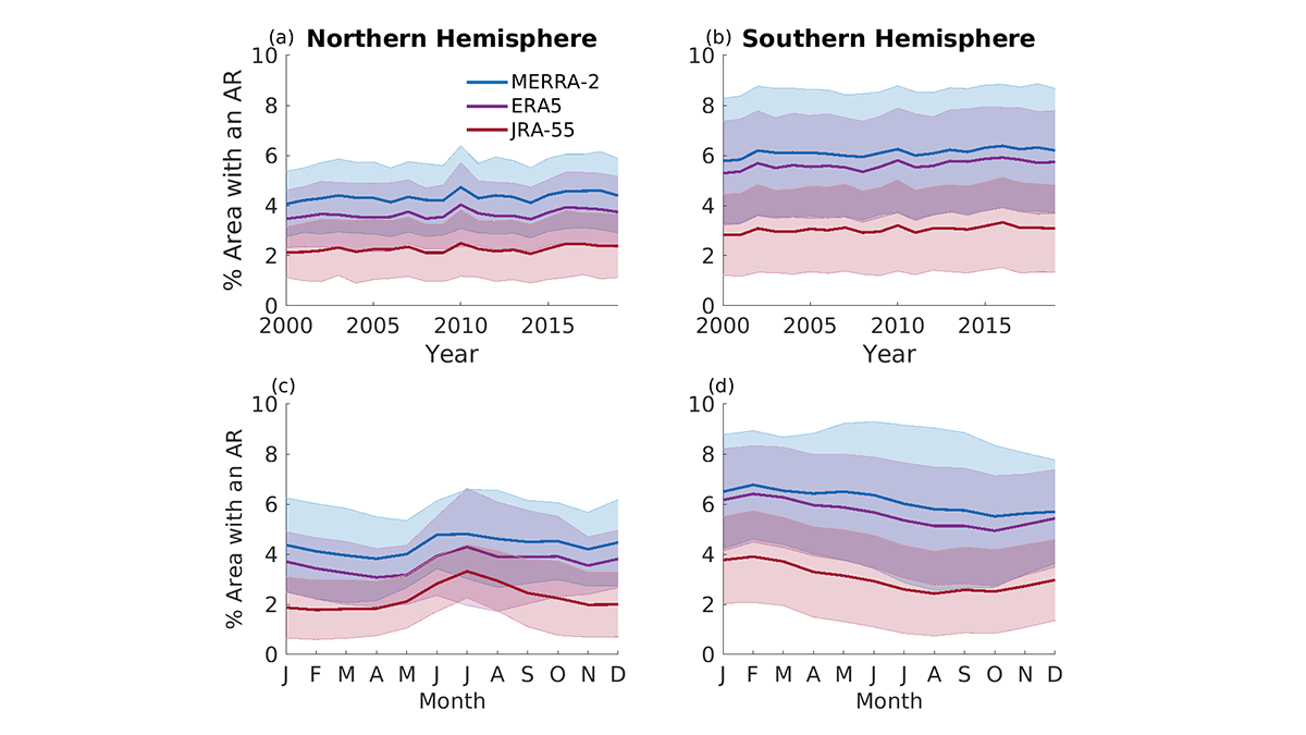
Results from the Atmospheric River Tracking Method Intercomparison Project (ARTMIP) describe the similarity and difference of using eleven detection algorithms and three reanalysis products.

Four satellite images showing pyroclastic material infill between 2014 and 2019.
Posted inEditors' Highlights

Volcanic Creation and Destruction of Temporary Tephra Storage

by Agnes Kontny 1 July 20225 June 2023

Pyroclastic density currents (PDCs) are a major threat during an explosive volcanic eruption. A new study shows that loose tephra accumulations on volcanic slopes tend to re-mobilize rapidly.

Map overlain with moisture, precipitation, and wind currents for the westward propagating moisture model.
Posted inEditors' Highlights

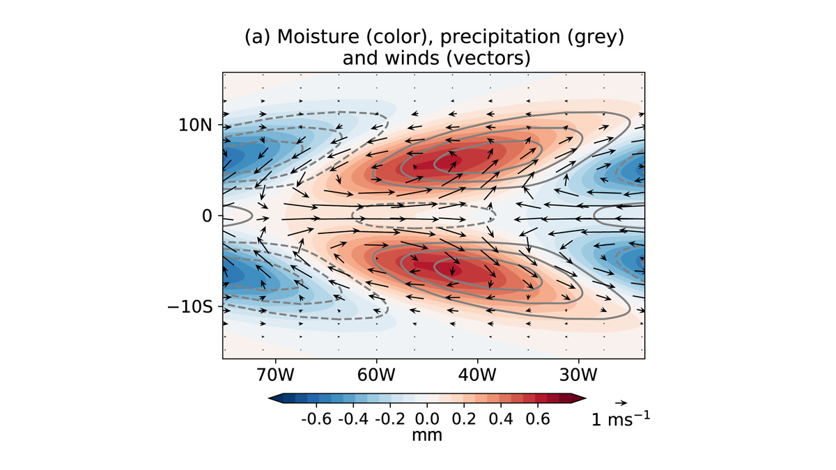
New Western Hemisphere Moisture Mode

by Suzana Camargo 24 June 202224 February 2023

A new study presents the first evidence of the existence of an intraseasonal westward-propagating moisture mode over the Western Hemisphere.

Diagram showing the three barriers in seasonal forecast and the Conditional Generative Forecasting methodology developed to tackle these three barriers.
Posted inEditors' Highlights

Learning from Climate Simulations for Global Seasonal Forecast

by Jiwen Fan 23 June 202222 December 2022

A probabilistic deep learning methodology that learns from climate simulation big data offers advantageous seasonal forecasting skill and crucial climate model diagnosis information at a global scale.

Image of Arrokoth showing the main geological features as well as total surface acceleration.
Posted inEditors' Highlights

A Glimpse at Planet Formation at the Dawn of the Solar System

by Matthias Grott 22 June 202221 December 2022

The low density of Kuiper Belt Object Arrokoth sheds light on the formation of planetesimals in the early solar system.

Photo of S-band radar site with Mt. Aragats in the background.
Posted inEditors' Highlights

Radar Diagnosis of the Thundercloud Electron Accelerator

by Minghua Zhang 14 June 202210 March 2023

Altitude-resolved S-band radar observations of graupel are used to decipher thunderstorm ground enhancements in surface electric field and gamma ray flux.

Image showing composite polar vortex structure for disturbed conditions.
Posted inEditors' Highlights

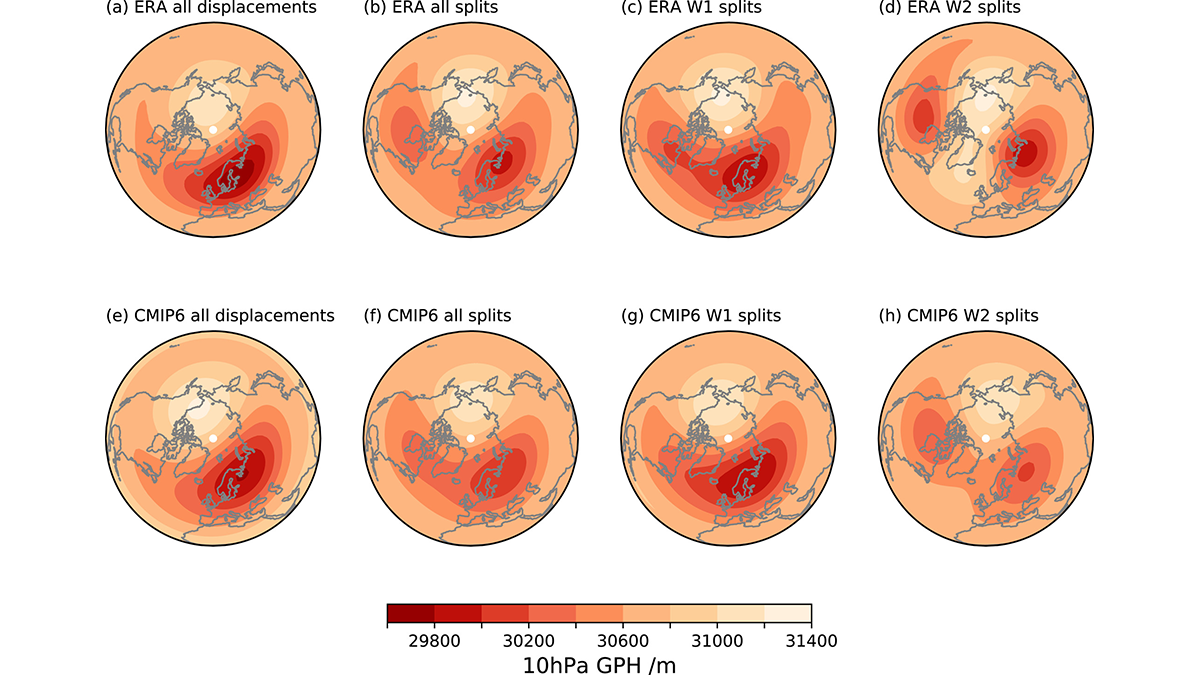
Simulating Surface Impacts of Stratospheric Sudden Warmings

by William J. Randel 10 June 202221 December 2022

New evaluations of climate model simulations show how the stratosphere polar vortex couples to surface weather.

Posts pagination

Newer posts 1 … 44 45 46 47 48 … 102 Older posts
A view of a Washington, D.C., skyline from the Potomac River at night. The Lincoln Memorial (at left) and the Washington Monument (at right) are lit against a purple sky. Over the water of the Potomac appear the text “#AGU24 coverage from Eos.”

Features from AGU Publications

Research Spotlights

A Solar Wind Squeeze May Have Strengthened Jovian Aurorae

1 August 20251 August 2025
Editors' Highlights

What Goes Up Must Come Down: Movement of Water in Europa’s Crust

31 July 202531 July 2025
Editors' Vox

JGR: Space Physics Launches New Instrumentation Article Type

23 July 202521 July 2025
Eos logo at left; AGU logo at right

About Eos
ENGAGE
Awards
Contact

Advertise
Submit
Career Center
Sitemap

© 2025 American Geophysical Union. All rights reserved Powered by Newspack