• About
  • Sections
  • Topics
    • Climate
    • Earth Science
    • Oceans
    • Space & Planets
    • Health & Ecosystems
    • Culture & Policy
    • Education & Careers
    • Opinions
  • Projects
    • ENGAGE
    • Editors’ Highlights
    • Editors’ Vox
    • Eos en Español
    • Eos 简体中文版
    • Print Archive
  • Blogs
    • Research & Developments
    • The Landslide Blog
  • Newsletter
  • Submit to Eos
  • AGU.org
  • Career Center
  • Join AGU
  • Give to AGU
  • About
  • Sections
  • Topics
    • Climate
    • Earth Science
    • Oceans
    • Space & Planets
    • Health & Ecosystems
    • Culture & Policy
    • Education & Careers
    • Opinions
  • Projects
    • ENGAGE
    • Editors’ Highlights
    • Editors’ Vox
    • Eos en Español
    • Eos 简体中文版
    • Print Archive
  • Blogs
    • Research & Developments
    • The Landslide Blog
  • Newsletter
  • Submit to Eos
Skip to content
  • AGU.org
  • Career Center
  • Join AGU
  • Give to AGU
Eos

Eos

Science News by AGU

Support Eos
Sign Up for Newsletter
  • About
  • Sections
  • Topics
    • Climate
    • Earth Science
    • Oceans
    • Space & Planets
    • Health & Ecosystems
    • Culture & Policy
    • Education & Careers
    • Opinions
  • Projects
    • ENGAGE
    • Editors’ Highlights
    • Editors’ Vox
    • Eos en Español
    • Eos 简体中文版
    • Print Archive
  • Blogs
    • Research & Developments
    • The Landslide Blog
  • Newsletter
  • Submit to Eos

disaster preparedness

Illustration of the AI algorithm estimating large earthquakes’ magnitudes on the basis of prompt elastogravity signals (PEGS) traveling at the speed of light, much faster than seismic (P and S) waves.
Posted inNews

Monitoring Earthquakes at the Speed of Light

by Mohammed El-Said 2 June 20222 June 2022

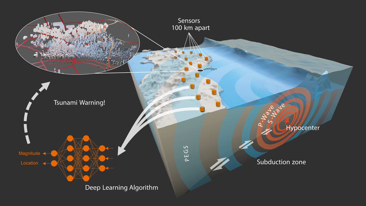
New research uses gravity and a machine learning model to instantaneously estimate the magnitude and location of large earthquakes.

The Secret Spire rock formation, or hoodoo, in Moab, Utah.
Posted inNews

Rock Music in Utah

by Robin Donovan 3 May 20229 May 2023

Three-dimensional models could help forecast rock tower frequencies—and seismic impacts—around the globe.

Incendios arden sobre las montañas cerca del lago Elsinore, California, el 9 de agosto de 2018.
Posted inNews

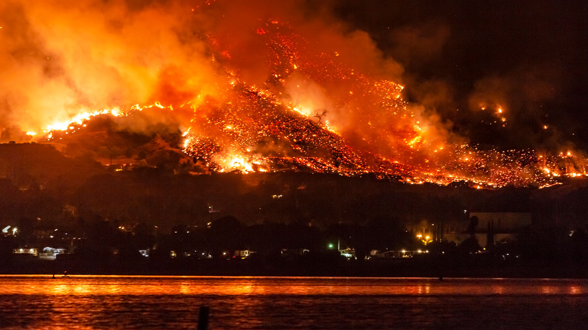
Los incendios forestales empeorarán, advierte informe de la ONU

by Meghie Rodrigues 26 April 20227 September 2022

Desde el ecuador hasta el Ártico, es probable que aumenten los incendios forestales y que el cambio climático los empeore, según un nuevo informe de las Naciones Unidas. La acción todavía es posible, dicen los autores.

New Zealand’s Whakaari/White Island
Posted inFeatures

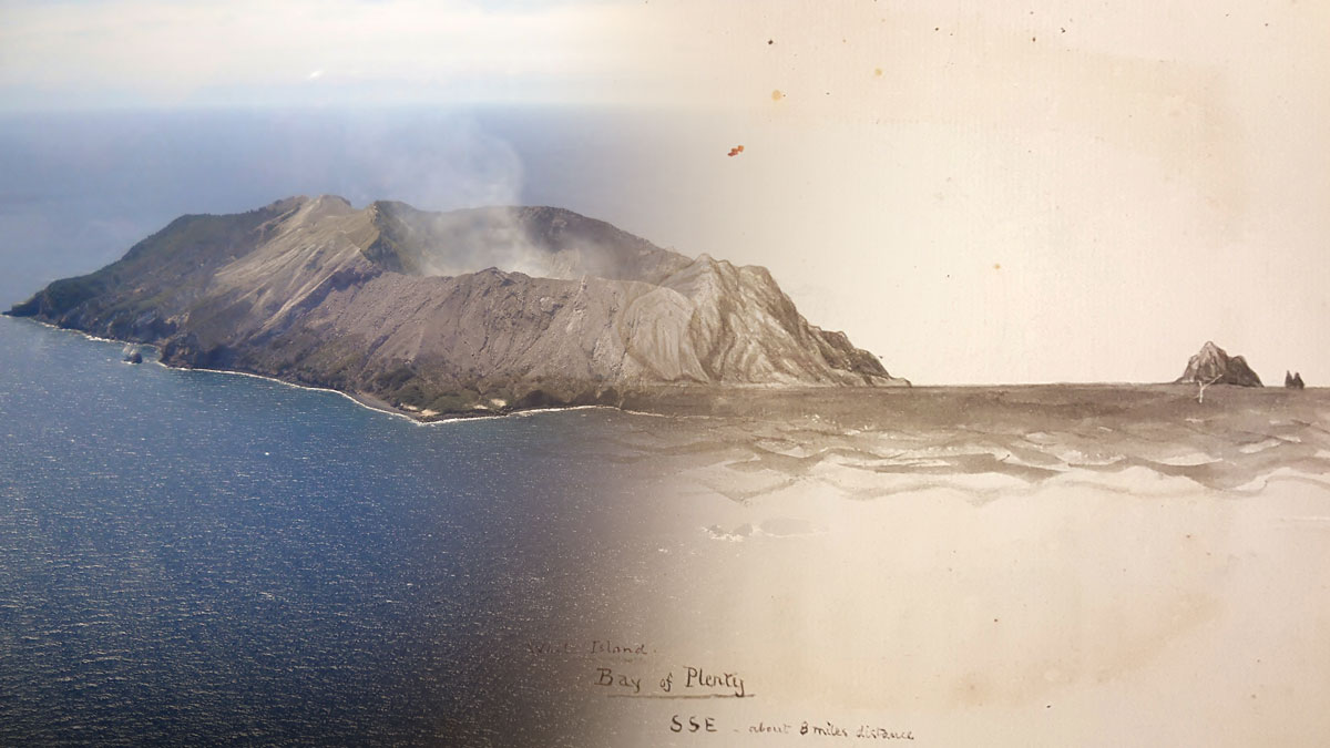
Studying Volcanoes through Myths, Legends, & Other Unconventional Data

by Nancy Averett 22 April 20221 June 2022

Studying historic eruptions through a storytelling lens often improves our understanding of and ability to prepare for such events.

Una imagen del Frjiol (Cloud Gate) en el Parque Milenio en Chicago. Varias personas están en la imagen con atuendos veraniegos.
Posted inResearch Spotlights

Estimando la frecuencia e intensidad las olas de calor: Un caso de estudio en Chicago

by Saima May Sidik 20 April 202220 April 2022

Modelado numérico mostró los impactos extendidos de la ola de calor del 2012 en Chicago, clarificando los impactos de la ola de calor y la isla de calor urbana en la temperatura de la ciudad.

Three rescue workers search through the rubble of a building destroyed by the 1999 Izmit earthquake in Turkey.
Posted inNews

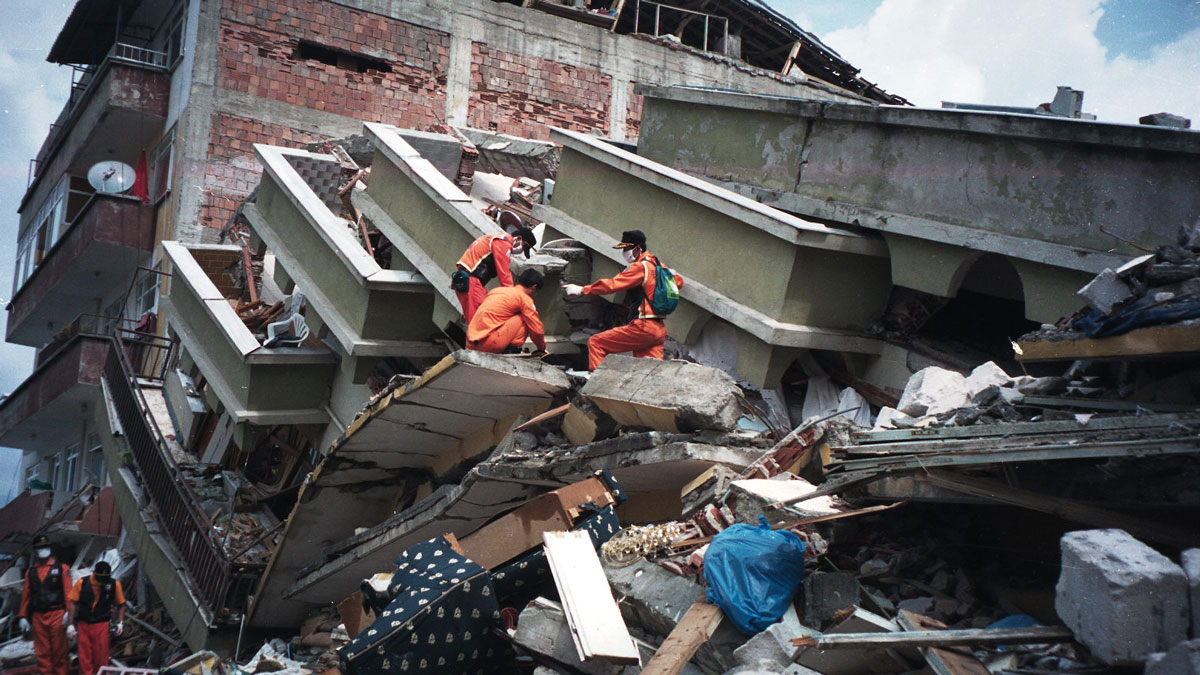
Do Earthquakes and Tectonic Plates Have a Two-Way Relationship?

Tim Hornyak, Science Writer by Tim Hornyak 18 April 20223 October 2022

A catastrophic earthquake in Turkey in 1999 changed the motion of the Anatolian plate, according to a study that could change the fundamentals of quake models.

Mangrove forest
Posted inNews

After a Hurricane, Coastal Systems Draw a Line in the Sand

by J. Besl 13 April 202213 April 2022

A new study finds nature can’t have it both ways: On the basis of thousands of case studies from dozens of hurricanes, there’s always a trade-off between resistance and resilience.

Maps of debris flow similarity index (DFSI) and the corresponding lengths of those debris flow channel segments.
Posted inEditors' Highlights

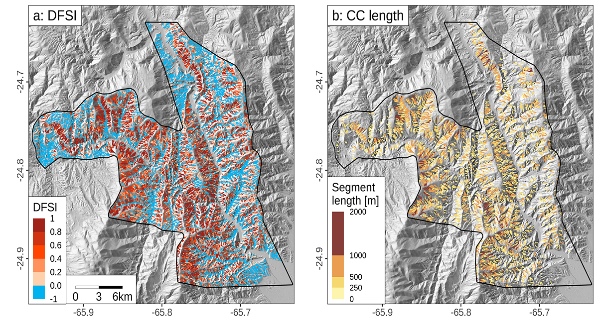
Debris Flows Keep the Landscape on the Straight and Narrow

by Adam Booth 6 April 20223 May 2022

New methods for identifying debris flow-shaped channels improve hazard quantification and highlight how high uplift rates and fractured bedrock facilitate debris flow-dominated landscape evolution.

A volcanic eruption spews molten rock into the sky.
Posted inNews

Magma Lingers at Different Depths on the Basis of Its Water Content

Katherine Kornei, Science Writer by Katherine Kornei 4 April 202225 April 2022

The discovery, gleaned from observations of volcanoes on four continents, could help constrain models of volcanic eruptions.

Skyline of the downtown business district of Addis Ababa, Ethiopia
Posted inNews

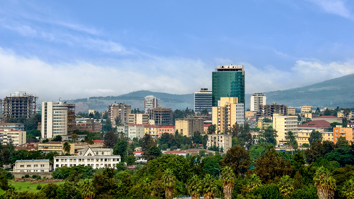
New Hazard Exposure Model for Africa

by Munyaradzi Makoni 31 March 202231 March 2022

The rapid pace of urbanization could encroach on hazard-prone regions without adequate land management and building design regulations, a new modeling project shows.

Posts pagination

Newer posts 1 … 5 6 7 8 9 … 19 Older posts
A view of a Washington, D.C., skyline from the Potomac River at night. The Lincoln Memorial (at left) and the Washington Monument (at right) are lit against a purple sky. Over the water of the Potomac appear the text “#AGU24 coverage from Eos.”

Features from AGU Publications

Research Spotlights

How Plants Respond to Scattered Sunlight

14 July 202514 July 2025
Editors' Highlights

The Power of Naming Space Weather Events

10 July 20258 July 2025
Editors' Vox

Water Tracks: The Veins of Thawing Landscapes

25 June 202525 June 2025
Eos logo at left; AGU logo at right

About Eos
ENGAGE
Awards
Contact

Advertise
Submit
Career Center
Sitemap

© 2025 American Geophysical Union. All rights reserved Powered by Newspack