
Editors’ Vox is a blog from AGU’s Publications Department.
When studying the subsurface of the Earth, scientists commonly use geophysical inverse modeling, which aims to infer key physical properties, like geological structures, from indirect observations. But these modeling techniques are typically high-dimensional and computationally demanding. To overcome these limitations, the scientific community is embracing Bayesian inference methods, which could offer a solution by integrating prior geological knowledge with observed data, enabling systematic uncertainty quantification.
A new article in Reviews of Geophysics explores recent advances in Bayesian methods for modeling the Earth’s subsurface from indirect geophysical data. Here, we asked the authors to give an overview of geophysical inverse modeling, how scientists use Bayesian inference, and what challenges remain.
In simple terms, what is geophysical inverse modeling?
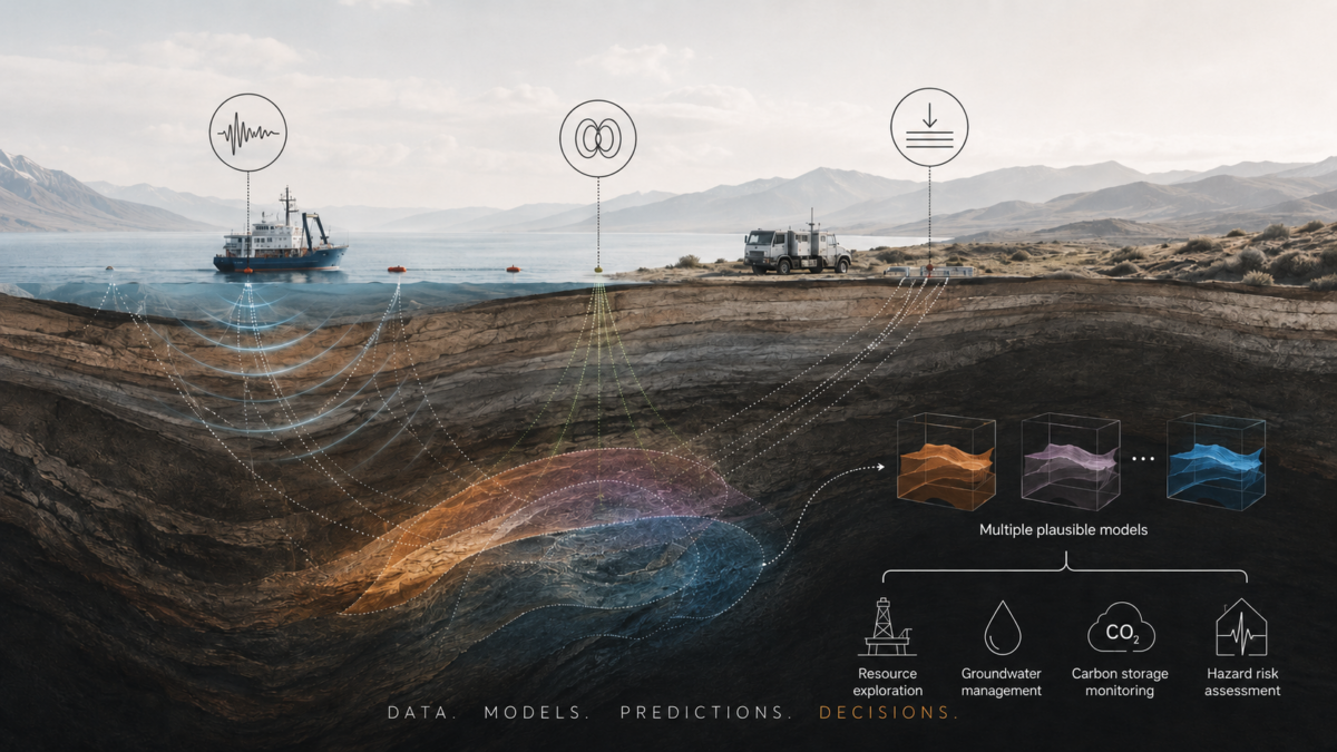
Many decisions depend on what lies beneath our feet: where to drill, whether carbon dioxide can be stored safely, how groundwater may move, or where a hidden fault may create risk. Yet most of the subsurface cannot be observed directly. Geophysical surveys provide clues by measuring seismic waves, electromagnetic fields, gravity, and other responses of the Earth. Inverse modeling works backward from those measurements. Scientists propose an underground model, use physical laws to predict the signals it would produce, compare those predictions with the observations, and revise the model. The result is not a photograph, but a scientifically constrained description of underground structures and properties.
What are the benefits and limitations of using geophysical inverse modeling?
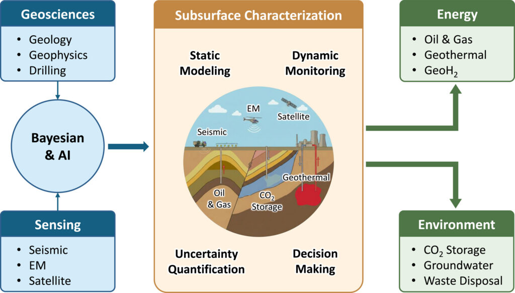
Geophysical inverse modeling can investigate large and deep regions without extensive drilling or excavation. It helps estimate rock velocity, electrical resistivity, density, porosity, fluid content, and the shape of faults, aquifers, or reservoirs. Its central limitation is that the data are noisy, incomplete, and unevenly informative. Different underground models can therefore produce very similar measurements. A single “best” model may look more certain than the evidence allows, while important alternatives remain hidden. For practical decisions, the key question is not only whether an image looks sharp. It is whether the remaining ambiguity could change a prediction or action, such as a drilling location, a monitoring plan, or a safety assessment.
What is Bayesian inference?
Bayesian inference is a way to update what we believe when new evidence arrives. A “prior” represents geological knowledge and plausible underground scenarios before the latest measurements are used. A “likelihood” describes how well each scenario explains the observed data, while accounting for measurement noise and modeling errors. Combining the two gives a “posterior,” a probability-weighted collection of scenarios that remain plausible after the evidence is considered. Rather than producing only one answer, Bayesian inversion shows which features are strongly supported, which remain uncertain, and how alternative interpretations compare. Those scenarios can then be carried forward into predictions and decisions, connecting data, models, possible outcomes, and action.
How has Bayesian inference improved subsurface modeling?
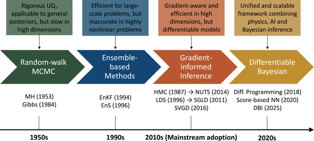
Bayesian inference has shifted the goal from finding one preferred underground model to evaluating a range of plausible models and predictions. This makes uncertainty an explicit result rather than an afterthought. Scientists can identify poorly constrained regions, reveal trade-offs between properties, combine different data types, and estimate the risk of costly misinterpretation. Bayesian analysis can also help determine which additional measurement would be most valuable. Recent gradient-informed methods use derivatives to navigate large model spaces more efficiently when the simulator is differentiable. Deep learning can represent realistic geological patterns, accelerate expensive physical simulations, and support rapid repeated inference. Together, these advances make uncertainty more useful for monitoring, planning, and decision-making.
What is Differentiable Bayesian Inversion, and what are its benefits?
Differentiable Bayesian Inversion, or DBI, is not a single new sampling algorithm. It is a unifying framework for linking geological knowledge, physical or learned simulators, models of measurement uncertainty, and Bayesian inference in one computational workflow. “Differentiable” means that software can track how a small change in an underground model affects the predicted data and how plausible that model is. Automatic differentiation can calculate these sensitivities through the full workflow. This common computational language allows physics-based models and machine-learning components to work together rather than remain separate boxes. Because the framework is modular, individual components can be improved or replaced. DBI could support faster, geologically realistic, uncertainty-aware inversion for monitoring and operational decisions.
What challenges remain?
The largest challenge is scale. Real three-dimensional problems may contain millions of unknowns, and every candidate model can require an expensive seismic, electromagnetic, or flow simulation. Plausible answers may also form several disconnected geological scenarios that are difficult to explore. AI models used to represent geology and fast surrogate simulators introduce further risks: they may fail when field conditions differ from their training data, and their errors can distort uncertainty estimates. Progress will require efficient differentiable solvers, more robust samplers, better uncertainty calibration, and validation on realistic field data. Gradient-free and hybrid methods will remain essential when models are not differentiable. The aim is not to eliminate uncertainty, but to identify which uncertainties matter and use them wisely.
—Mingliang Liu ([email protected];  0000-0002-5783-4490), Shandong University, China, and Stanford University, United States; Dario Grana (0000-0003-4220-053X), University of Wyoming, United States; Klaus Mosegaard (0000-0001-5292-5249), University of Copenhagen, Denmark; Mrinal K. Sen (0000-0002-5525-0467), The University of Texas at Austin, United States; Minghui Xu (0000-0001-9567-5569), Stanford University, United States; and Tapan Mukerji (0000-0003-1711-1850), Stanford University, United States
Editor’s Note: It is the policy of AGU Publications to invite the authors of articles published in Reviews of Geophysics to write a summary for Eos Editors’ Vox.