

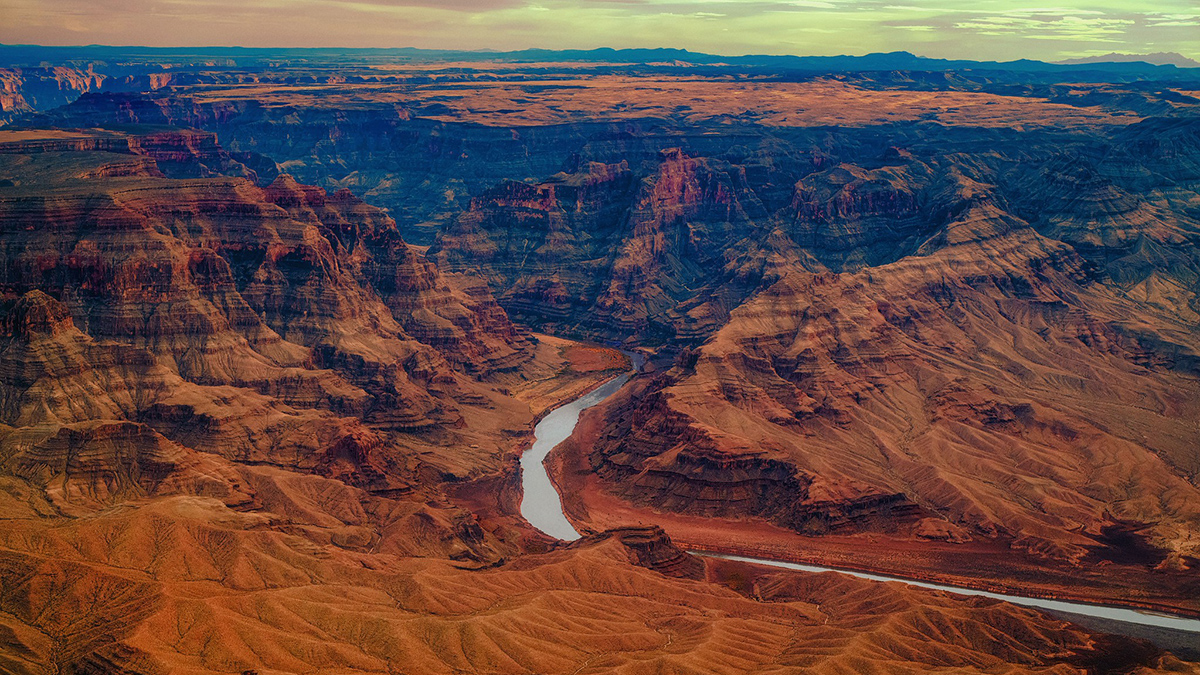
The Colorado River and its reservoirs, which supply water for about 40 million people and 30 tribes across seven states and two countries, is drying up.
Lake Mead on the Arizona-Nevada border, which has the largest storage capacity of any reservoir in the United States, hit its lowest recorded levels on 7 August. Water levels in Lake Powell, located on the Utah-Arizona border, reached their own record low about a week later.
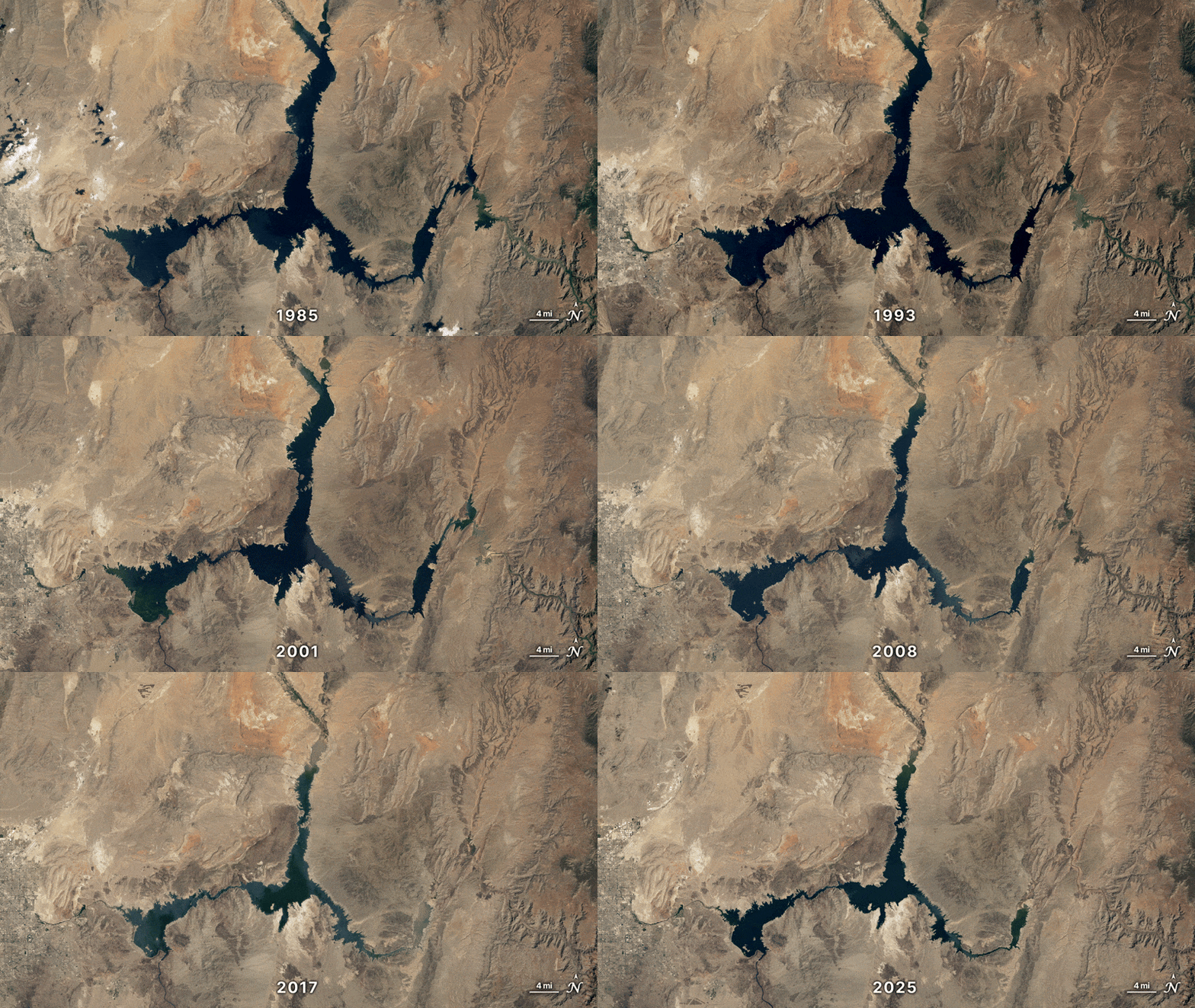
Though overallocation is one reason the river is shrinking, reduced snowpack and increased evaporation caused by climate change are also contributing factors.
“The Colorado River crisis is one of the clearest examples of climate change in the U.S.”
“The Colorado River crisis is one of the clearest examples of climate change in the U.S.,” Douglas Kenney, the director of the Western Water Policy Program and a hydroscientist at the University of Colorado Boulder, said in an email to Eos. “The basin has warmed dramatically, especially over the last 30 years, changing virtually every aspect of the water cycle in ways that result in lower streamflows. Flows so far in the 21st century are 20 percent lower than the 20th century. In an already arid region with very few water sources, that is a huge issue.”
Last week, the Department of the Interior (DOI) issued a final decision for what to do about all of this, at least for the next 2 years. Among the primary takeaways are 1.25 million acre-feet of water cuts across what are known as the Lower Basin states: 760,000 acre-feet for Arizona, 440,000 acre-feet for California, and 50,000 acre-feet for Nevada. (One acre-foot is equivalent to 325,851 gallons (1,233 cubic meters), or enough water for a year for two to four single-family homes.) This number represents a cut of about 21% across the Lower Basin states, but the cuts could increase in coming years.
The Upper Basin states—Colorado, New Mexico, Utah, and Wyoming—are not facing cuts. The “record of decision,” as it is called, also established criteria for how to maintain enough water in Lake Powell to continue operating Glen Canyon Dam.
By the Numbers
20%: amount by which the Colorado River’s flow has reduced since 2000
40 million: number of people who rely on the river’s water
30: Native American tribes in the Colorado River Basin
27%: Lake Mead’s current level, relative to full capacity
21%: Lake Powell’s current level, relative to full capacity
John Berggren, a regional policy manager with Western Resource Advocates, said the record of decision puts the future of the Colorado River Basin “on the right path” but that the new guidelines don’t make management of the river sustainable or resilient in the long term.
“In the short term, we got a little bit of certainty in how they’re going to operate, but fingers crossed for a big snowpack. Otherwise, we’re not going to be in a good spot come next year,” he said. “Best case is in 2 years, we’re kind of where we are now, which is just barely hanging on by a thread, and very vulnerable to one more bad year that could completely tank the system.”
The DOI announcement followed the release of a final environmental impact statement (FEIS) in late July 2026 and a draft EIS in January 2026. The draft itself followed about 2.5 years of negotiations between the Bureau of Reclamation and the seven basin states.
The public had 45 days to comment on the proposal before the FEIS was released. The Bureau of Reclamation received more than 18,000 submissions, most of which were form letters, and responded to the comments in a 54-page document. Read some of the public comments from different parts of the Colorado River Basin in the map below.
“We are grateful for the Seven Basin States, the thirty Basin Tribes, Mexico, and many other basin stakeholders who have provided the feedback and voluntary arrangements necessary for the development of the 2027–2028 Operating Guidelines,” Secretary of the Interior Doug Burgum said in a statement accompanying the release of the record of decision.
The Haves and Have-Nots
The FEIS released in August included the idea that the Lower Basin states be asked to cut their water by as much as 3 million acre-feet—more than twice the amount decided for 2027 and 2028. And greater cuts are still on the table for future years.
Arizona, which faced the most severe cuts, was particularly unhappy with the FEIS. The Arizona Department of Water Resources (ADWR) called parts of the proposal “unacceptable” and said that “such reductions would devastate Arizona’s water users and its economy.” In a letter to DOI’s Assistant Secretary for Water and Science Andrea Travnicek, ADWR director Thomas Buschatzke effectively threatened to sue, noting that “Arizona reserves the right to seek the resolution of its Compact rights in an appropriate judicial forum.”
In response to the record of decision, Buschatzke struck a more positive note, thanking the Department of the Interior “for clarifying the decision-making process” and stating that the “actions in the Lower Basin in recent decades to protect the system have demonstrated how much we can accomplish when we all join together as part of the solution.”
On X, Arizona Governor Katie Hobbs said, “We’ve protected Arizona from disastrous and unacceptable forced federal water cuts…But the work is not over.”
Arizona’s Gila River Indian Community released a statement saying that the document “fails to adequately address the federal government’s trust responsibility to tribes in the Basin who are seriously affected by cuts to critical water supplies.”
JB Hamby, Colorado River commissioner for California, called the record of decision “a bridge, not a permanent solution,” and added that “three states cannot carry the responsibility of all seven.”
Nevada Governor Joe Lombardo released a statement the day the record of decision came out, saying that “the federal government is positioning to short Nevada—the state with the smallest river allocation at only 1.8%—sacrificing the health and safety of Nevadans before requiring equal water responsibility for our shared water resources from the Upper Basin.”
On Monday, 24 August, the state of Nevada, the Colorado River Commission of Nevada, and the Southern Nevada Water Authority filed a lawsuit against the DOI and Bureau of Reclamation. The lawsuit claims the record of decision gives the federal government the authority to impose an annual reduction of 213,556 acre-feet on the state—about 71% of Nevada’s allocation.
“The magnitude of such shortages will cause acute environmental, socioeconomic, and health and human safety impacts to southern Nevada,” the lawsuit reads.
Upper Basin states are happier: The governors of Colorado, Wyoming, Utah, and New Mexico released a joint statement following the release of the FEIS, noting that they were “encouraged” by the suggested new operating guidelines. (They did not release a new statement in response to the record of decision, but neither document proposed water cuts to the Upper Basin states.)
What About the Science?
In 2023, Shemin Ge, a hydrogeologist at the University of Colorado Boulder, was lead author of an article for Eos about how it was important that, unlike the drafting of the original 1922 agreement for managing the river, all involved parties use the best available science to inform their decisions.
Nearly 200 people from the Bureau of Reclamation, the Bureau of Indian Affairs, the National Park Service, the U.S. Fish and Wildlife Service, the U.S. Geological Survey, and other agencies helped prepare the FEIS. The report summarizes how the proposed plans could affect everything from river flow to groundwater levels to sand transport to harmful algal blooms. It also analyzes the impact on vegetation, terrestrial and riverine wildlife, paleontological resource preservation, socioeconomics, agriculture, Native American tribes, and recreation.
But is this plan any better than the 1922 compact? Ge said she’s not sure.
“My impression about these government documents, whether it’s a decision, a record, or guideline, [is that] it’s more a short-term operational document.”
“My impression about these government documents, whether it’s a decision, a record, or guideline, [is that] it’s more a short-term operational document,” she said. “Many experts have called for more holistic, science-based, long-term strategies to manage the river, and I don’t feel that it’s heard at the upper level.” By long-term future, Ge added, she’s “talking about maybe 20 years, not 2 years.”
Kenney said that the FEIS raised the questions of whether the cuts are equitably distributed (the Lower Basin states certainly don’t think so), whether the cuts will be enough to solve the problem (“The best we can probably hope for is to avoid further reservoir declines,” he said), and whether the Bureau of Reclamation will actually be able to enforce the suggested framework.
“Given all that, I’m not sure the framework will be effective in practice, but it is well reasoned,” he said. “It’s likely the best they can do with the tools they have. A true solution likely requires permanently removing a lot of agriculture in the basin, and that’s not really a job for a water agency.”
—Emily Gardner (@emfurd.bsky.social), Deputy Editor