
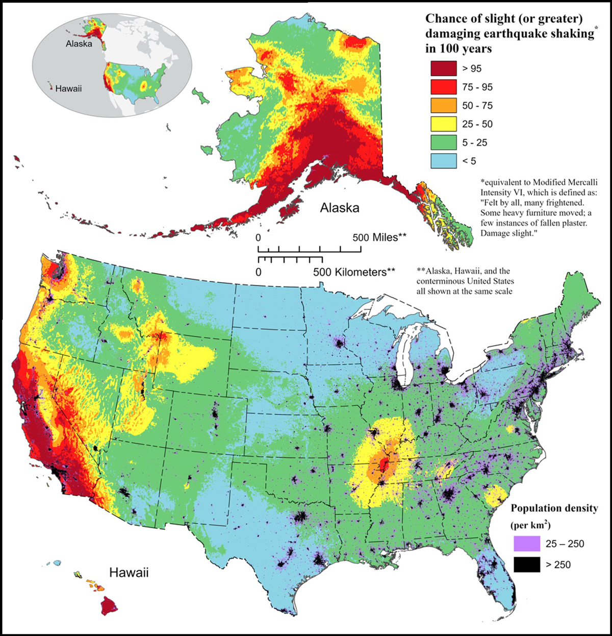
Almost 15% of the U.S. population is “somewhat likely” to experience a damaging earthquake in the coming decades, according to the recently published U.S. National Seismic Hazard Model (NSHM).
The model, created by scientists at the U.S. Geological Survey (USGS), synthesizes seismic and geological data to identify which regions of the country are at risk of strong shaking. The team visualized the model with a countrywide map of the probability of damaging shaking.
“Updated hazard models serve important purposes.”
It is the first iteration of the NSHM to include all 50 states and has been updated from past models published in 2018 (contiguous United States), 1998 (Hawaii), and 2007 (Alaska).
“Updated hazard models serve important purposes,” said James Neely, a seismologist at the University of Chicago who was not involved in developing the model. “They help remind the general public of earthquake hazards, inform policy planners about what earthquake hazards they need to prepare for, and tell engineers how much shaking to expect when designing buildings and infrastructure.”
The Faults in Our Crust
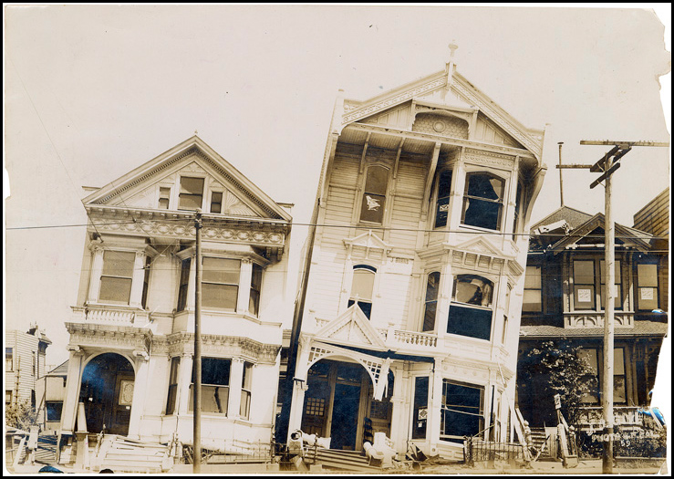
Earth’s crust is crisscrossed by faults. An earthquake occurs when blocks of rock move quickly past one another along a fault. The ensuing shaking can have potentially catastrophic consequences for people living nearby. The famous 1906 earthquake in San Francisco, caused by sudden slip along the San Andreas Fault, destroyed parts of the city and killed more than 3,000 people.
Today, most San Franciscans are aware of the seismic threat under their feet, but the authors of the NSHM report noted that damaging earthquakes can also occur where there is no recent history of seismic activity. In 2020, a magnitude 5.7 earthquake near Magna, Utah, took many by surprise, causing considerable damage and raising concerns about seismic preparedness in the Salt Lake Valley.
To assess earthquake risks across the United States, the NSHM group used data on the magnitude, location, and timing of more than 130,000 cataloged seismic events. Data from past earthquakes are key to forecasting the magnitude and frequency of future events along the same fault.
First, earthquakes induced by mining, wastewater injection, or other human activities were removed from the catalog; the hazard map depicts only natural hazards. Aftershocks were also removed because they occur as a result of a main shock and cause a particular hazard to be overrepresented.
The researchers used the resulting data set to estimate the rate at which earthquakes occur across the United States. They calculated the strength of ground shaking for all earthquakes with magnitudes greater than 5.0, which are likely to cause damaging shaking.
The 2023 NSHM added 350 faults to past models, bringing the total number to 1,000 and providing a more comprehensive view of possible seismic sources.
Compiling the data and creating the model were a multiyear collaborative effort. “The new 2023 U.S. 50-state National Seismic Hazard Model was developed with input from hundreds of scientists and engineers across the country,” said Mark Petersen, a research geophysicist at the USGS and lead author of the study. The hazard model will guide policy and infrastructure decisions that help to mitigate earthquake damage.
High Hazard in California, Alaska, and Hawaii
According to the NSHM, seismic hazard is highest in California, southern Alaska, and Hawaii; some regions have a 95% probability of suffering a damaging earthquake within a century. The estimated hazard in these states has increased compared to previous models as a result of more complete earthquake catalogs, better fault maps, and an updated understanding of ground shaking.
Western Nevada, the Wasatch Range in Utah, the Yellowstone region, and the New Madrid Seismic Zone (located at the nexus of Tennessee, Arkansas, Missouri, Illinois, and Kentucky) are likely to experience strong shaking in the future.
Notably, the model ups the possibility of damaging earthquakes in the Atlantic coastal corridor, which includes Boston, New York, Philadelphia, and Washington, D.C. Although the seismic hazard in the area is still generally low, the corridor is densely populated, so an increased hazard affects a large number of people.
Around 49 million people in the United States are “somewhat likely” to experience a damaging earthquake in the next 50 years.
The scientists calculated that around 49 million people are “somewhat likely” to experience a damaging earthquake in the next 50 years, meaning they have a 50% chance of feeling strong shaking.
The number of people with a 10% chance of feeling strong shaking (188 million) increased by 66% from the previous model, largely because of the increased seismic hazard in the northeastern United States.
On the other hand, for roughly 40% of the U.S. population (140 million people), the risk of experiencing a damaging quake is less than 10%.
The release of the updated model doesn’t mean seismologists and hazard researchers can rest on their laurels. The USGS is already anticipating future updates, including the use of more regional models of faults and ground conditions, according to Petersen.
“Over time, seismologists gain a better understanding of earthquakes,” Neely said. “Seismic hazard work is iterative, and our models are constantly being refined.”
—Caroline Hasler (@carbonbasedcary), Science Writer