Editors’ Highlights are summaries of recent papers by AGU’s journal editors.
Source: Earth and Space Science
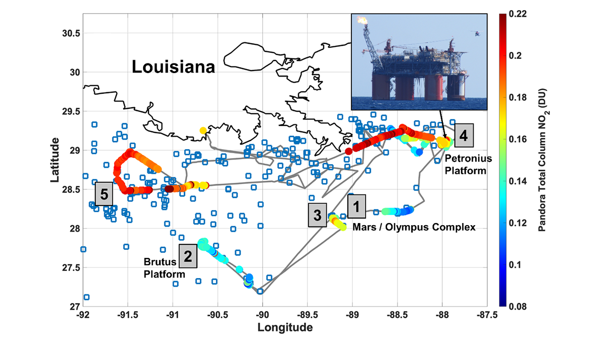
The Bureau of Ocean Energy Management (BOEM) is mandated to monitor the effects of Gulf of Mexico (GOM) oil and natural gas (ONG) operations on US air quality. However, there are no surface air quality monitors in the Gulf of Mexico. To solve this problem, BOEM partnered with NASA to assess the use of satellites to measure nitrogen dioxide (NO2), a harmful pollutant and key component of “nose-level” ozone formation, over ONG operations in GOM, and to validate the accuracy of the satellite measurements. The May 2019 Satellite Coastal and Oceanic Atmospheric Pollution Experiment (SCOAPE) GOM cruise on the R/V Point Sur found that satellite NO2 measurements are generally of sufficient accuracy to monitor GOM air quality near ONG operations.
However, several cases of surface and remotely sensed NO2 “spikes” near specific ONG platforms (see Figure) indicated that challenges remain in relating column (e.g., satellite or Pandora) measurements to surface air quality. The SCOAPE cruise encountered two distinct meteorological regimes causing at first clean conditions, then more polluted conditions when air came from continental and urban emissions regions. This presents an additional challenge to remote sensing along the coast where continental NO2 generally outweighs near-shore ONG sources. With ozone, carbon monoxide, methane, and volatile organic compounds also measured on the R/V Point Sur, SCOAPE provided the first comprehensive view of Gulf of Mexico air quality and a reference for the future.
Thompson et al. [2023] indicate that ONG NO2 emissions are detectable by satellite and surface remote sensors. This gives promise to quantifying ONG air quality impacts with a new generation of geostationary satellites that will provide hourly NO2 measurements compared to current once-daily capabilities. NASA and BOEM are preparing to validate NASA’s upcoming Tropospheric Emissions: Monitoring Pollution (TEMPO) geostationary sensor by returning to the Gulf in 2024.
Citation: Thompson, A. M., Kollonige, D. E., Stauffer, R. M., Kotsakis, A. E., Abuhassan, N., Lamsal, L. N., et al. (2023). Two air quality regimes in total column NO2 over the Gulf of Mexico in May 2019: Shipboard and satellite views. Earth and Space Science, 10, e2022EA002473. https://doi.org/10.1029/2022EA002473
—Jonathan H. Jiang, Editor, Earth and Space Science