
Humans are limited. We can’t fly, breathe underwater, or survive in high temperatures. So we’ve left much of our scientific endeavors to instruments that extend and collect information beyond our senses, like seismometers that detect waves moving through Earth, lidar instruments that can measure elevation, and sensors that can determine the salinity of the oceans.
Increasingly, a new technology is furthering scientists’ ability to capture Earth’s vast, unreachable spaces: drones. These remote-controlled vehicles—sometimes called unmanned aerial vehicles (UAV) or autonomous underwater vehicles (AUV)—can travel to hazardous places humans try to avoid, like up close to a volcanic eruption or underneath meters of sea ice. Now more than ever, robots are scattered across the planet, engaged in some heavy science.
This week marks the 20th annual Earth Science Week, founded by the American Geosciences Institute. This year’s theme, “Earth and Human Activity,” emphasizes the ways in which humans affect Earth and the ways Earth affects humans. In celebration of Earth Science Week, we want to highlight some of the many ways drones help us understand our planet and the changes we make to it.
Here are some of the ways scientist use drones.
1. To Find Sources of Pollution
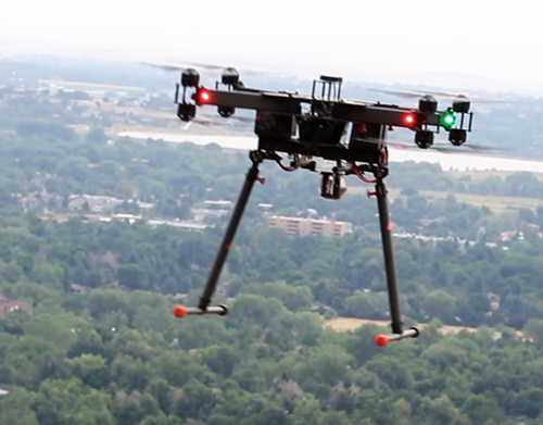
Scientists have invented an instrument that when affixed to a drone, can help them detect and find the source of air pollution at ultrafine scales. The instrument uses spectroscopy to pinpoint the composition of a gas in a given area and precisely measure its concentration. Applications range from understanding dynamics at the boundaries of atmospheric layers to detecting chemical weapons.
2. To Study Why Climate Change Affects the Arctic So Severely
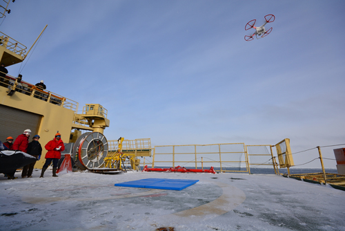
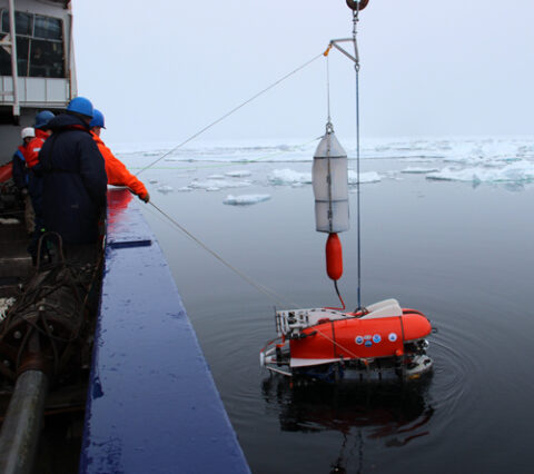
Scientists working on Alaska’s North Slope are using drones to monitor gas concentrations in three dimensions over the Arctic. Some drones have even dropped buoys into the surface ocean. Combined, these instruments help researchers study the physics of the transition region between frozen sea and open water. This transition is a crucial element of climate models in the Arctic.
3. To Peer into Volcanoes
Researchers used drones to peer down the throat of one of the world’s most active volcanoes: Stromboli, in Italy. The drone flew through clouds of ash plumes above the erupting volcano and snapped high-resolution pictures and videos of Stromboli’s active and nonactive vents.
4. To Show that Typical Ground Truths Overestimate Earth’s Albedo
Researchers use satellites to study how Earth reflects and absorbs light. They rely on on-the-ground weather stations to calibrate their measurements. However, some drone-operating scientists recently found that these weather stations may be overestimating how much light gets reflected because they don’t take into account certain surrounding topography. The drones helped to show that in some cases, albedo in certain places can be overestimated by up to 10%.
5. To Explore the Expanse of Sea Ice Beyond the Decks of Their Icebreaker Ships
Researchers working in the Arctic and Antarctic have piloted drones to altitudes of 500 meters over the ice. Images collected helped scientists study the distribution of ice floes, mechanisms of pancake ice formation, and ocean wave–sea ice interactions. Drones in these environments can provide crucial information on how sea ice recovers in autumn, a time when harsh conditions hinder many research expeditions.
6. To Study Propagating Cracks in Glaciers
In 2015, researchers used a drone to monitor a crack that had sprouted in Greenland’s Bowdoin Glacier. Over several days, the drone captured thousands of images, allowing researchers to model the crack’s propagation. Someday, these kinds of data may allow scientists to predict when an iceberg might calve from a glacier.
7. To See an Entire Floodplain from the Sky
Scientists are employing drones to help them study the geologic remnants of the Lake Missoula floods, in which more than 2000 cubic kilometers of water burst from a glacial dam and flowed across the Pacific Northwest as many as 100 times between 18,000 and 13,000 years ago. The drones survey wide swaths of land, searching for large-scale ripple marks and flow scars—features too vast to see from the ground.
8. To Help Detect Gas Leaks Underwater
Researchers have tested a method that can help AUVs pinpoint dangerous gas emissions from underwater sources, such as from oil wells or stored natural gas. The idea goes like this: When broad surveys detect some form of underwater leak, researchers deploy a drone to find it. Then, each location where the drone fails to detect the origin of the leak will update a map so that it shows regions where the drone has the next highest probability of finding the leak.
9. To Map the Bottom of Highly Acidic Lakes
Across Earth, there are 35 volcanic lakes that can build up gas to the point where waters sometimes explode. In 2016, scientists traveled to Laguna Caliente in Costa Rica to test out an autonomous underwater vehicle—basically, a drone that can swim.
The rugged AUV survived in 55°C water that was 3 times more acidic than battery acid. Unfortunately, on its second venture into the lake, the AUV succumbed to an explosion that sent acidic waves over its hull. The team has since built a new drone.
10. To Visit Under-Ice Ecosystems
In 2014, some scientists tested an AUV in the ocean near Greenland, sending it to examine the under-ice ecosystem. The drone revealed a world that surprised the researchers—high amounts of algae and other biology that likely supports a diverse food web under the ice. Researchers hope that a better understanding of the existing ecosystems will help them understand how climate change may alter those ecosystems.
11. To Help Track Underwater Avalanches
In 2015, researchers deployed AUVs to help them place beach ball–shaped benthic event detectors on the seafloor in Monterey, Calif. The balls are engineered to roll with material that slides down continental slopes. Through these sensors, scientists hope to understand how quickly and how far sediment flows during underwater avalanches.
12. To Find Shipwrecks
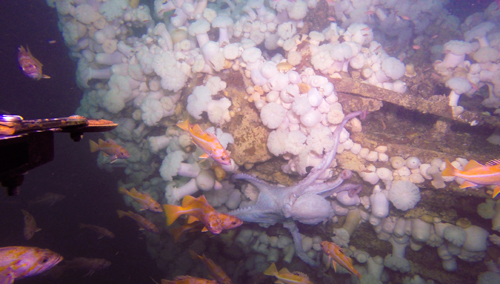
In 2014, National Oceanic and Atmospheric Administration scientists sent an AUV equipped with sonar capabilities to investigate an ancient shipwreck about 5 kilometers off the coast of Southeast Farallon Island. Five years prior, a routine sonar survey of that patch of ocean floor revealed a previously overlooked shipwreck. The drone, along with another remotely operated vehicle that took pictures and videos, discovered that the shipwreck was the long-missing USS Conestoga, which researchers had been searching for since it vanished 95 years ago.
13. To Detect Ever-So-Slight Changes in Earth’s Elevation
Drones in the Jet Propulsion Laboratory’s Uninhabited Aerial Vehicle Synthetic Aperture Radar program help researchers study Earth’s surface. The autopiloted crafts are programmed to fly the same path again and again, using radar signals to gather information about the surface. When these signals are compared to one other, scientists can see how the land has changed between flights. These craft can detect land subsidence or even tiny changes in elevation after an earthquake.
—JoAnna Wendel (@JoAnnaScience), Staff Writer
Citation:
Wendel, J. (2017), Thirteen innovative ways humans use drones, Eos, 98, https://doi.org/10.1029/2017EO084489. Published on 11 October 2017.
Text © 2017. The authors. CC BY-NC-ND 3.0
Except where otherwise noted, images are subject to copyright. Any reuse without express permission from the copyright owner is prohibited.