Plate tectonics just turned 50. The theory of how our planet’s lithosphere—its outer layer—changes shape and evolves is probably one of the most important scientific advancements of all time.
Before tectonics, scientists couldn’t explain many natural phenomena, such as why earthquakes are common in certain areas and extremely rare in others, why volcanoes occasionally form in chains, and why fossils of the same species turn up in continents thousands of kilometers apart.
With time, scientists have also realized that tectonics is the driving force behind most of the climate changes that our planet has endured over geological time.
At a rate of millimeters per year, continents drift, break into smaller pieces, and crash into each other. This dance opens and closes seaways and builds mountain ranges and, in so doing, changes winds and ocean currents across the globe.
In an upcoming paper in the journal Tectonics, a group of researchers led by geographer and climate modeling expert Gilles Ramstein of the Laboratory of Climate and Environmental Sciences in France shows the importance of these processes trough three dramatic examples: the freezing of the whole planet, or snowball Earth; the closing of the Paratethys and development of the Southeast Asian monsoon; and the uplift of plateaus surrounding the East African Rift.
Snowball Earth
Over millions of years, the amount of carbon dioxide in the atmosphere is regulated by the global exposure of silicate rocks to weathering. When calcium silicates mix with water, for instance, carbon dioxide from the atmosphere reacts with calcium in the rocks to form calcium carbonate. The result is carbon sequestration, the removal of carbon dioxide from the atmosphere.
Exposed silicates are more prone to weathering in tropical areas with high humidity, precipitation, and temperature. If large concentrations of silicate rocks are in the warm and wet regions near the tropics, more carbon dioxide is removed from the atmosphere, reducing the global greenhouse effect and cooling the climate. In the absence of silicate rocks in tropical and subtropical regions, carbon dioxide builds up in the atmosphere, and the climate becomes warmer.
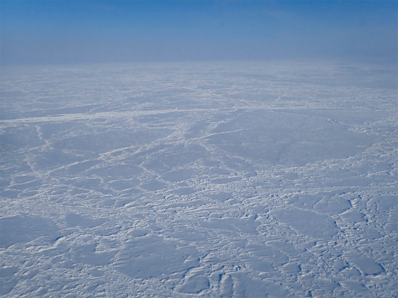
This geologic cycle is dramatically represented by the shifting continents and climates of snowball Earth.
About 750 million years ago, during the period known as the Neoproterozoic, a very peculiar configuration of tectonic plates occurred, causing one of the most striking episodes of our planet’s geologic and atmospheric history: Earth fully covered by ice.
The process started when the supercontinent Rodinia, formed 1.1 billion years ago, started to break into smaller continental plates. Rodinia was located near the equator, and the resulting continents also remained in the tropical band.
“The snowball state is unstable in our planet; it can’t last more than several million years, and this is the result of tectonics, climate, and carbon dioxide.”
As a supercontinent, Rodinia was probably extremely arid. Not much moisture could reach its interior. When it broke up, the smaller continents had warm and humid climates, similar to present-day Central America.
The new continental configuration exposed enormous volumes of silicate rock to weathering, removing huge quantities of carbon dioxide from the atmosphere. Carbon dioxide dissolved by rainwater and suspended in rivers and clouds eventually reached the oceans, where it was sequestered in the seabed.
When atmospheric carbon dioxide levels dipped to 200 parts per million, about half our current levels, ice sheets began to grow at both poles. As the ice sheets grew, they reflected more and more sunlight back to space, cooling the climate even further. Eventually, the whole planet was covered by ice.
This snowball state eventually receded. When ice covered the entire planet, the hydrological cycle stopped, preventing more silicate weathering. Tectonics and volcanism remained active, however, and pumped carbon dioxide into the atmosphere, eventually warming the climate again.
“The snowball state is unstable in our planet; it can’t last more than several million years, and this is the result of tectonics, climate, and carbon dioxide,” Ramstein said.
Two snowball glaciations happened in a window of 100 million years.
“The climate is going back into a snowball as long as the continents are still located in the same place,” said Yves Goddéris, a climate researcher at the National Center for Scientific Research in France who has worked extensively to model the snowball Earth phenomenon.
“There was a third glaciation 518 million years ago, but it wasn’t a snowball,” Goddéris explained. “This is because the continents were moving slowly toward the poles to form Gondwana, and this wasn’t the right configuration for a third snowball glaciation.”
Researchers speculate that the snowball period might have triggered the Cambrian explosion, which began 50 million years after the second snowball Earth episode. Before the glaciations, only microbial life existed, but 50 million years later the oceans filled with an unprecedented diversity of animal species. The glaciation might have caused a mass extinction that wiped out dominant organisms or allowed a sudden influx of nutrients into the oceans that favored the evolution of new life-forms.
“Microbial life is too difficult to study in the sediments,” Goddéris said, “so nobody knows exactly.”
Kick-Starting the Southeast Asian Monsoon
During the 1980s and 1990s, a hot topic in geophysics was the study of the uplift of the Tibetan Plateau and how it marked the evolution of the Southeast Asian monsoon.
The Tibetan Plateau is the largest and highest plateau in the world, extending to about half of the size of the continental United States, with an average elevation of 4,500 meters above sea level. It started forming around 55 million years ago when the Indian Plate collided with the Eurasian Plate.
When the Sun heats the Tibetan Plateau in the summer, it generates huge upward convection currents that suck air from surrounding regions. This process brings moisture-laden air from the Indian Ocean, causing the monsoon over Southeast Asia.
For a long time, researchers tried to model how the Tibetan Plateau triggered the onset of the Asian monsoon.
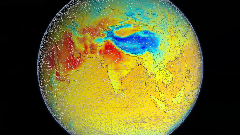
The Southeast Asian monsoon developed its full force only after a large epicontinental sea known as the Paratethys disappeared.
But toward the end of the 20th century, Ramstein, along with a graduate student named Frédéric Fluteau, used computer simulations to show that the Southeast Asian monsoon developed its full force only after a large epicontinental sea known as the Paratethys disappeared. The Paratethys covered a huge area from Europe to western Siberia and disappeared about 7 million years ago as the African and Arabian Plates moved northward. The Caspian Sea, the Black Sea, and Lake Baikal are remnants of this long-lost body of water.
The Paratethys had dampened the regional climate, preventing extreme seasons, and “when the Paratethys disappeared,” Ramstein explained, “it left behind a huge continental mass with an extreme climate.”
Scientists are still trying to determine the tectonics-monsoon link and to discriminate the roles of uplift, land-sea distribution, and global cooling. But it is clear that the closing of the Paratethys played a major role, said Zhengtang Guo, a professor in the Institute of Geology and Geophysics of the University of Chinese Academy of Sciences.
Rocking Humanity’s Cradle
As our ancestors evolved in Africa, two tectonic events drastically changed the climate of the continent: the uplift of plateaus surrounding the East African Rift and the closing of the Paratethys.
Sometimes, tectonics can combine with Earth’s orbital oscillations to influence climate changes over shorter timescales. The ice ages during the Quaternary period, extending from 2.6 million years ago to the present day, are an example of this mechanism at play.
Similar tectonic and orbital interplay is involved in the rapid climatic changes that have occurred in eastern and central Africa over the past 7 million years, probably contributing to the evolution and dispersion of our human ancestors.
As our ancestors evolved in Africa, two tectonic events drastically changed the climate of the continent: the uplift of plateaus surrounding the East African Rift and the closing of the Paratethys.
The shrinking of the Paratethys caused North Africa to become more and more arid, leading to the onset of the Sahara desert about 7 million years ago. It also made the African climate extremely sensitive to the precession cycle of Earth’s orbit.
This cycle, also known as the Milankovitch cycle, affects the duration and intensity of the seasons and can cause periods when strong monsoons drive moist winds from the tropical Atlantic into central Africa and the Sahara.
“When the east of Europe and west of Asia were no longer covered by the epicontinental sea, it created a huge land area that changed the configuration of the monsoon system,” Ramstein said. “When the shrinkage of the Paratethys finished, the sensitivity to the precision signal was huge.”
As a result of this cycle, roughly every 20,000 years the monsoons are reinforced, causing 6,000-year wet periods. During these periods, the Sahara turns green with vegetation, rivers, and lakes. Lake Chad in central Africa becomes a Mega-Chad, and it can reach the size of Germany. This cycle still affects the African climate, and scientists estimate that the last occurrence of a green Sahara and Lake Mega-Chad ended roughly 5,000 years ago.
Millions of years ago, our hominin ancestors were living continuously in East Africa, which was then covered by tropical forests. But as it turns out, some of the oldest known hominin fossils weren’t found there, but thousands of kilometers west, near Lake Chad.
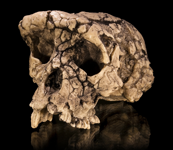
The fossils comprise the skull of a hominin, nicknamed Toumaï by its discoverers, who lived in the area about 7 million years ago. Toumaï belonged to an extinct species called Sahelanthropus tchadensis.
“Why do we find Toumaï near Lake Chad?” Ramstein wondered. Because, he reasoned, every few thousand years the region is covered by vegetation and water is available year-round. “This is why you can find some hominids near this lake during that period, because it was just possible to go from east to west.”
Shortly after, the uplift of East African plateaus began, heralding the emergence of the East African Rift. This process changed the flat landscape of tropical forests east of the rift into highlands and grasslands. “At this time the hominids were forced not only to disperse but also to evolve to adapt to this open environment,” Ramstein said.
Lessons for the Present
“The only thing that can help us is to understand that Earth’s history moves very slowly.”
Tectonics and paleoclimate can provide insights for Earth’s future and are particularly relevant for a future involving climate change. During the Pliocene, about 3 million years ago, atmospheric carbon dioxide (CO2) levels were similar to what we are experiencing today. Then, the temperature was 2°C warmer, and the sea level was 15 times higher.
“The only thing that can help us is to understand that Earth’s history moves very slowly,” Ramstein said. “It took the Earth 40 million years to reduce the CO2 levels from 1,000 to 300 parts per million at the beginning of the Quaternary, and this is the tempo of the natural things.” Now, we are reversing that process in just 200 years.
If we were to maintain our current CO2 levels, we would still lose ice sheets covering Greenland and part of Antarctica, Ramstein explained. “So I think paleoclimate helps us to understand what we are doing but doesn’t give us the keys to cope with it.”
—Javier Barbuzano (@javibarbuzano), Freelance Science Journalist
Citation:
Barbuzano, J. (2019), Three times tectonics changed the climate, Eos, 100, https://doi.org/10.1029/2019EO136786. Published on 22 November 2019.
Text © 2019. The authors. CC BY-NC-ND 3.0
Except where otherwise noted, images are subject to copyright. Any reuse without express permission from the copyright owner is prohibited.