
Since geologic time began, Earth’s surface has been evolving through natural processes of tectonic uplift, volcanism, erosion, and the movement of sediment. Now a new force of global change is altering Earth’s surface and morphology in unprecedented ways: humanity.
A new force of global change is altering Earth’s surface and morphology in unprecedented ways: humanity.
Human activities are leaving their fingerprints across Earth (Figure 1), driven by increasing populations, technological capacities, and societal demands [e.g., Ellis, 2015; Brown et al., 2017; Waters et al., 2016]. We have altered flood patterns, created barriers to runoff and erosion, funneled sedimentation into specific areas, flattened mountains, piled hills, dredged land from the sea, and even triggered seismic activity [Tarolli and Sofia, 2016]. These and other changes can pose broad threats to the sustainability of human societies and environments.
If increasingly globalized societies are to make better land management decisions, the geosciences must globally evaluate how humans are reshaping Earth’s surface. A comprehensive mapping of human topographic signatures on a planet-wide scale is required if we are to understand, model, and forecast the geological hazards of the future.
Understanding and addressing the causes and consequences of anthropogenic landform modifications are a worldwide challenge. But this challenge also poses an opportunity to better manage environmental resources and protect environmental values [DeFries et al., 2012].
The Challenge of Three Dimensions
“If life happens in three dimensions, why doesn’t science?” This question, posed more than a decade ago in Nature [Butler, 2006], resonates when assessing human reshaping of Earth’s landscapes.
Landforms are shaped in three dimensions by natural processes and societal demands [e.g., Sidle and Ziegler, 2012; Guthrie, 2015]; societies in turn are shaped by the landscapes they alter. Understanding and modeling these interacting forces across Earth are no small challenge.
For example, observing and modeling the direct effects of some of the most widespread forms of human topographic modification, such as soil tillage and terracing [Tarolli et al., 2014], are possible only with very fine spatial resolutions (i.e., ≤1 meter). Yet these features are common all over the world. High-resolution three-dimensional topographic data at global scales are needed to observe and appraise them.
The Need for a Unified, Global Topographic Data Set
High-resolution terrain data such as lidar [Tarolli, 2014], aerial photogrammetry [Eltner et al., 2016], and satellite observations [Famiglietti et al., 2015] are increasingly available to the scientific community. These data sets are also becoming available to land planners and the public, as governments, academic institutions, and others in the remote sensing community seize the opportunity for high-resolution topographic data sharing (Figure 2) [Wulder and Coops, 2014; Verburg et al., 2015]
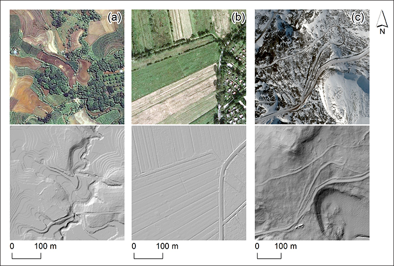
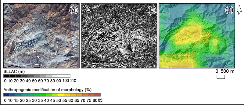
Thanks to these geodata, anthropogenic signatures are widely observable across the globe, under vegetation cover (Figure 2a), at very fine spatial scales (e.g., agricultural practices and plowing; Figure 2b) and at large spatial scales (e.g., major open pit mines; Figure 3), and far from contemporary human settlements (Figure 2c). So the potential to assess the global topographic fingerprints of humanity using high-resolution terrain data is a tantalizing prospect.
However, despite a growing number of local projects at fine scales, a global data set remains nonetheless elusive. This lack of global data is largely the result of technical challenges to sharing very large data sets and issues of data ownership and permissions.
But once a global database exists, advances in the technical capacity to handle and analyze large data sets could be utilized to map anthropogenic signatures in detail (e.g., using a close-range terrestrial laser scanner) and across larger areas (e.g., using satellite data). Together with geomorphic analyses, the potential is clear for an innovative, transformative, and global-scale assessment of the extent to which humans shape Earth’s landscapes.
For example, a fine-scale analysis of terrain data can detect specific anthropogenic configurations in the organization of surface features (Figure 3b) [Sofia et al., 2014], revealing modifications that humans make across landscapes (Figure 3c). Such fine-scale geomorphic changes are generally invisible to coarser scales of observation and analysis, making it appear that natural landforms and natural hydrological and sedimentary processes are unaltered. Failure to observe such changes misrepresents the true extent and form of human modifications of terrain, with huge consequences when inaccurate data are used to assess risks from runoff, landslides, and other geologic hazards to society [Tarolli, 2014].
Topography for Society
A global map of the topographic signatures of humanity would create an unparalleled opportunity to change both scientific and public perspectives on the human role in reshaping Earth’s land surface. A worldwide inventory of anthropogenic geomorphologies would enable geoscientists to assess the extent to which human societies have reshaped geomorphic processes globally and provide a tool for monitoring these changes over time.
Such monitoring would facilitate unprecedented insights into the dynamics and sensitivity of landscapes and their responses to human forcings at global scale. In turn, these insights would help cities, resource managers, and the public better understand and mediate their social and environmental actions.
As we move deeper into the Anthropocene, a comprehensive mapping of human topographic signatures will be increasingly necessary to understand, model, and forecast the geological hazards of the future. These hazards will likely be manifold.
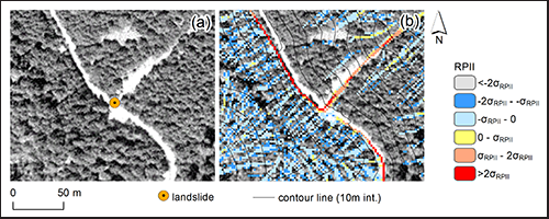
For example, landscapes across the world face altered flooding regimes in densely populated floodplains, erosion rates associated with road networks, altered runoff and erosion due to agricultural practices, and sediment release and seismic activity from mining [Tarolli and Sofia, 2016]. Modifications in land use (e.g., urbanization and changes in agricultural practices) alter water infiltration and runoff production, increasing flooding risks in floodplains. Increases in road density cause land degradation and erosion (Figure 4), especially when roads are poorly planned and constructed without well-designed drainage systems, leading to destabilized hillslopes and landslides. Erosion from agricultural fields can exceed rates of soil production, causing soil degradation and reducing crop yields, water quality, and food production. Mining areas, even years after reclamation, can induce seismicity, landslides, soil erosion, and terrain collapse, damaging environments and surface structures.
Without accurate data on anthropogenic topography, communities will find it difficult to develop and implement strategies and practices aimed at reducing or mitigating the social and environmental impacts of anthropogenic geomorphic change.
Earth Science Community’s Perspective Needed
Technological advances in Earth observation have made possible what might have been inconceivable just a few years ago. A global map and inventory of human topographic signatures in three dimensions at high spatial resolution can now become a reality.
The search for humanity’s topographical fingerprints will require a more generalized methodology for discovering and assessing these signatures.
Collecting and broadening access to high spatial resolution (meter to submeter scale), Earth science–oriented topography data acquired with lidar and other technologies would promote scientific discovery while fostering international interactions and knowledge exchange across the Earth science community. At the same time, enlarging the search for humanity’s topographical fingerprints to the full spectrum of environmental and cultural settings across Earth’s surface will require a more generalized methodology for discovering and assessing these signatures.
These two parallel needs are where scientific efforts should focus. It is time for the Earth science community to come together and bring the topographic fingerprints of humanity to the eyes and minds of the current and future stewards, shapers, curators, and managers of Earth’s land surface.
Acknowledgments
Data sets for Figure 1 are from Utah Automated Geographic Reference Center (AGRC), Geospatial Information Office. Data sets for Figures 2(a)–2(c) are from the University of the Philippines Training Center for Applied Geodesy and Photogrammetry (TCAGP), Noh and Howat [2015], and Freie und Hansestadt Hamburg (from 2014), respectively. Data sets for Figure 3 are from Centre National d’Études Spatiales (CNES©), France, Distribution Airbus DS. Data sets for Figure 4 are from the HJ Andrews Experimental Forest research program, National Science Foundation’s Long-Term Ecological Research Program (NSF LTER, DEB 08-23380), U.S. Forest Service (USFS) Pacific Northwest Research Station, and Oregon State University (OSU).
References
Butler, D. (2006), Virtual globes: The web-wide world, Nature, 439, 776–778, https://doi.org/10.1038/439776a.
Brown, A. G., et al. (2017), The geomorphology of the Anthropocene: Emergence, status and implications, Earth Surf. Processes Landforms, 42, 71–90, https://doi.org/10.1002/esp.3943.
DeFries, R. S., et al. (2012), Planetary opportunities: A social contract for global change science to contribute to a sustainable future, BioScience, 62, 603–606, https://doi.org/10.1525/bio.2012.62.6.11.
Ellis, E. C. (2015), Ecology in an anthropogenic biosphere, Ecol. Monogr., 85, 287–331, https://doi.org/10.1890/14-2274.1.
Eltner, A., et al. (2016), Image-based surface reconstruction in geomorphometry—Merits, limits and developments, Earth Surf. Dyn., 4, 359–389, https://doi.org/10.5194/esurf-4-359-2016.
Famiglietti, J. S., et al. (2015), Satellites provide the big picture, Science, 349, 684–685, https://doi.org/10.1126/science.aac9238.
Guthrie, R. (2015), The catastrophic nature of humans, Nat. Geosci. 8, 421–422, https://doi.org/10.1038/ngeo2455.
Noh, M. J., and I. M. Howat (2015), Automated stereo-photogrammetric DEM generation at high latitudes: Surface Extraction with TIN-based Search-space Minimization (SETSM) validation and demonstration over glaciated regions, GIScience Remote Sens., 52(2), 198–217, https://doi.org/10.1080/15481603.2015.1008621.
Sidle, R. C., and A. D. Ziegler (2012), The dilemma of mountain roads, Nat. Geosci, 5, 437–438, https://doi.org/10.1038/ngeo1512.
Sofia, G., F. Marinello, and P. Tarolli (2014), A new landscape metric for the identification of terraced sites: The slope local length of auto-correlation (SLLAC), ISPRS J. Photogramm. Remote Sens., 96, 123–133, https://doi.org/10.1016/j.isprsjprs.2014.06.018.
Tarolli, P. (2014), High-resolution topography for understanding Earth surface processes: Opportunities and challenges, Geomorphology, 216, 295–312, https://doi.org/10.1016/j.geomorph.2014.03.008.
Tarolli, P., and G. Sofia (2016), Human topographic signatures and derived geomorphic processes across landscapes, Geomorphology, 255, 140–161, https://doi.org/10.1016/j.geomorph.2015.12.007.
Tarolli, P., et al. (2013), Recognition of surface flow processes influenced by roads and trails in mountain areas using high-resolution topography, Eur. J. Remote Sens., 46, 176–197.
Tarolli, P., F. Preti, and N. Romano (2014), Terraced landscapes: From an old best practice to a potential hazard for soil degradation due to land abandonment, Anthropocene, 6, 10–25, https://doi.org/10.1016/j.ancene.2014.03.002.
Verburg, P. H., et al. (2015), Land system science and sustainable development of the Earth system: A global land project perspective, Anthropocene, 12, 29–41, https://doi.org/10.1016/j.ancene.2015.09.004.
Waters, C. N., et al. (2016), The Anthropocene is functionally and stratigraphically distinct from the Holocene, Science, 351, aad2622, https://doi.org/10.1126/science.aad2622.
Wulder, M. A., and N. C. Coops (2014), Satellites: Make Earth observations open access, Nature, 513, 30–31, https://doi.org/10.1038/513030a.
—Paolo Tarolli (email: [email protected]; @TarolliP) and Giulia Sofia (@jubermensch2), Department of Land, Environment, Agriculture, and Forestry, University of Padova, Legnaro, Italy; and Erle Ellis (@erleellis), Department of Geography and Environmental Systems, University of Maryland, Baltimore County, Baltimore
Citation:
Tarolli, P., G. Sofia, and E. Ellis (2017), Mapping the topographic fingerprints of humanity across Earth, Eos, 98, https://doi.org/10.1029/2017EO069637. Published on 16 March 2017.
Text © 2017. The authors. CC BY-NC-ND 3.0
Except where otherwise noted, images are subject to copyright. Any reuse without express permission from the copyright owner is prohibited.