From forecasting the incidence of oxygen-depleted “dead zones” in the Chesapeake Bay and northern Gulf of Mexico to predicting circulation along the U.S. West Coast and storm surges in the Caribbean, coastal and ocean modeling offers tools that can help save lives, protect property, and sustain marine resources.
The Coastal and Ocean Modeling Testbed (COMT) supports this effort by conducting targeted research and development aimed at speeding up the process by which scientific and technical advances from the coastal and ocean modeling research community are transitioned into improved operational ocean products and services.
The COMT program, led by the Southeastern Universities Research Association (SURA), is part of the National Oceanic and Atmospheric Administration’s (NOAA) Integrated Ocean Observing System (IOOS) effort. Projects supported through COMT are designed to assess the performance of existing models, create new model code and tools as necessary, inform and train users, and build a repository of evaluation data sets to expand and improve the modeling capabilities of operational partners and the broader coastal and ocean modeling community.
The initial COMT program began in 2010 and was completed in 2013. A description of the program from its inception and a compilation of scientific results are available in a special issue of the Journal of Geophysical Research: Oceans [Luettich et al., 2013].
The current COMT program began in 2013 and includes participants from academia, the private sector, and government agencies (Table 1). Here we highlight progress in five ongoing COMT projects.
| Table 1. Coastal and Ocean Modeling Testbed Collaborators and Partners | |||
| University Collaborators | Government Collaborators | Industry/Nongovernmental Organization Collaborators | Partners |
| Dalhousie University
Louisiana State University Oregon State University Texas A&M University University of California, San Diego University of California, Santa Cruz University of Maryland University of Maine University of North Carolina University of Notre Dame University of Puerto Rico University of Washington Virginia Institute of Marine Science, College of William and Mary Woods Hole Oceanographic Institution | Center for Operational Oceanographic Products and Services, NOAA
Environmental Modeling Center, NOAA National Hurricane Center, NOAA U.S. Integrated Ocean Observing System, NOAA Naval Research Laboratory, U.S. Navy Coastal and Hydraulics Laboratory, U.S. Army Corps of Engineers Gulf Ecology Division, U.S. Environmental Protection Agency | Remote Sensing Solutions
RPS Applied Science Associates Southeastern Universities Research Association | IOOS regional associations for Southern California, central and Northern California, Pacific Northwest, Mid-Atlantic, Gulf of Mexico, and Caribbean
Chesapeake Bay Program Office, U.S. Environmental Protection Agency National Environmental Satellite, Data, and Information Service, NOAA National Ocean Service, NOAA National Weather Service, NOAA U.S. Geological Survey |
Chesapeake Bay Oxygen Depletion
Changes in levels of dissolved oxygen have a significant effect on the health of the Chesapeake Bay, an estuary located in the Mid-Atlantic region of the U.S. East Coast. Excessively low oxygen levels can stress or kill fish and other animals, creating dead zones within the bay.
COMT’s Chesapeake Bay project seeks to improve models of dissolved oxygen concentration in the estuary, taking into consideration a variety of contributing factors. The study is designed to provide a better understanding of the uncertainty inherent in predictions of such properties as salinity, temperature, chlorophyll content, and nutrient concentration and how this uncertainty contributes to the predictability of dissolved oxygen levels.
The project team compared the regulatory model used by Chesapeake Bay program managers with research models currently being used by the scientific community and found that the regulatory model performed as well as many of the scientific models. This result gives program managers and academic scientists more confidence in the regulatory model.
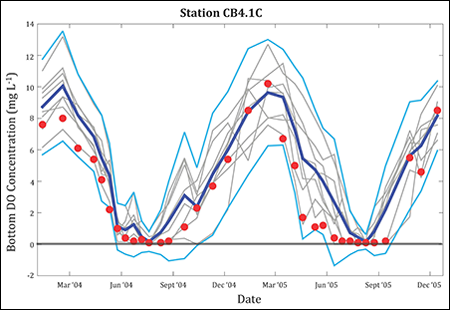
The team also found that an ensemble mean of multiple models is better at predicting hypoxia than any individual model (Figure 1), illustrating the potential value of multimodel ensembles for decision-making concerning the Chesapeake Bay.
Project researchers developed a simple one-term model for hypoxia (oxygen deficiency in the environment) for use in day-to-day operational forecasts. The model is currently providing same-day and 3-day forecasts of Chesapeake Bay hypoxia on the Virginia Institute of Marine Science website. The team is pursuing incorporation of this tool into NOAA’s Chesapeake Bay Operational Forecast System.
The Chesapeake Bay project is also running a variety of scenarios using multiple models, including the regulatory program model, to assess responses to nutrient load reductions and future climate change. These results will help inform coastal resource managers directing the restoration and protection of the Chesapeake Bay.
Gulf of Mexico Oxygen Depletion
Dissolved oxygen depletion is also a significant problem in the Gulf of Mexico, where a large hypoxic area forms every summer over the Texas-Louisiana shelf in the northern part of the gulf.
As in the Chesapeake Bay project, COMT’s Gulf of Mexico study is focusing on identifying factors that influence the prediction of dissolved oxygen concentration. This is done to improve understanding of the controlling processes and to provide guidance on the eventual implementation of dissolved oxygen forecasts in NOAA’s Northern Gulf of Mexico Operational Forecast System.
Scenario-based simulations assess the potential impacts of nutrient management decisions and future climate conditions.
A comparison of three coupled hydrodynamic-ecosystem models has shown that skillful hypoxia predictions in this region require accurate reproduction of bottom water temperature, bottom boundary layer thickness, and vertical attenuation of short-wave solar radiation (the way that the water column filters out the blue and ultraviolet wavelengths of sunlight at progressively greater depths) [Fennel et al., 2016].
Project researchers are conducting scenario-based simulations to assess the potential impacts of nutrient management decisions in the Mississippi River Basin and future climate conditions on hypoxia in the northern Gulf of Mexico. Results are informing the interagency Hypoxia Task Force’s efforts to devise near-term and long-term nutrient management strategies.
West Coast Forecast System
COMT’s West Coast project is part of a larger NOAA effort to develop a new U.S. West Coast basin-wide operational forecast system (WCOFS). Operational forecast systems provide near-term and long-term predictions of such factors as wind, temperature, water levels, salinity, currents, and, eventually, water biogeochemistry.
The project’s 6-year evaluation of the Regional Ocean Modeling System (ROMS) shows that this model can realistically reproduce ocean variability on temporal scales from a few days to years along the entire U.S. West Coast.
The project team is studying three biogeochemical models of differing complexity, already incorporated into ROMS, to identify advantages and limitations of the varying model formulations and to assess associated rate processes.
Data assimilation is a critical future component of the WCOFS. Thus, we are also evaluating approaches to data assimilation in ROMS using new metrics for assessing model and assimilation system skill. We have shown that existing observational data are reasonably effective at correcting model representations of circulation associated with the California Current system.
Close coordination between the COMT team and the WCOFS implementation team is helping to accelerate the development of WCOFS at NOAA.
Caribbean Surge and Wave Modeling
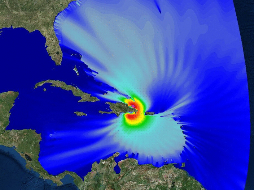
Intense storms bring high waves and surges that can inundate coastal areas and flood rivers. COMT’s Caribbean project aims to extend effective forecasting of waves and storm surges from gently sloped areas, such as the Gulf of Mexico’s northern edge, to steep-sloped areas, like those surrounding Caribbean islands.
Taking advantage of observational data available for Puerto Rico and the U.S. Virgin Islands, the project team evaluated a number of models for their effectiveness in predicting storm surges and coastal inundation.
Regional-scale model runs for Hurricane Georges (1998) and Hurricane Irene (2011) elucidated the relative roles of wind forcing and wave forcing on storm surge and inundation in Puerto Rico. These model runs used the Advanced Circulation model (ADCIRC) and NOAA’s Sea, Lake, and Overland Surges from Hurricanes (SLOSH) model, coupled to the Simulating Waves Nearshore (SWAN) model.
The following animations show a modeled surface wavefield, illustrating water level changes as Hurricane Georges approaches Puerto Rico, with a close-up showing wave heights as the hurricane makes landfall at Vieques and the eastern end of Puerto Rico. Red and yellow colors indicate significant wave height.

Comparisons between the coupled ADCIRC-SWAN model and the SLOSH-SWAN model, developed during the original COMT program, have helped to document the performance of the latter approach. On the basis of these findings, the National Hurricane Center used the coupled SLOSH-SWAN model to produce the first surge and inundation hazard database for Puerto Rico that includes the effect of waves.
The associated Storm Surge Maximum Envelope of Water (MEOW) and Storm Surge Maximum of the Maximum (MOM) models are now providing crucial guidance tools for the Puerto Rico Weather Forecast Office and are being used in the development of evacuation zones for the National Hurricane Program’s hurricane evacuation studies.
Model Viewer
The COMT computer infrastructure project is focused on archiving data for evaluating models, providing tools to discover and access these data, and creating visualizations of model outputs.
Although researchers often have in-house visualization and analysis tools tailored for use with their specific numerical models, our new model viewer allows the simultaneous visualization of results from different models. This facilitates model comparisons and helps extend the value of COMT results to future modeling research and development activities.
Fostering Collaboration
Since 2010, COMT has facilitated collaboration among more than 20 universities and a range of government agencies.
Since 2010, COMT has facilitated collaboration among more than 20 universities and a range of government agencies, including NOAA, the U.S. Navy, the Environmental Protection Agency, and the U.S. Army Corps of Engineers. COMT is now 1 of 11 official NOAA test beds.
Collaboration has underpinned program success from the outset, within the academic community, and, more important, between academia and operational users. Such collaboration requires dedicated effort, along with a mutual acceptance of goals, critical assessment of diverse approaches, iterative updates, promotion of new paradigms, and effective communication.
Scientific understanding, like nature, is impermanent and dynamic. We expect COMT to continue to evolve in concert with the operational use of the coastal and ocean models that it is intended to advance.
References
Fennel, K., et al. (2016), Effects of model physics on hypoxia simulations for the northern Gulf of Mexico: A model intercomparison, J. Geophys. Res. Oceans, 121, 5731–5750, https://doi.org/10.1002/2015JC011577.
Irby, I. D., et al. (2016), Challenges associated with modeling low-oxygen waters in Chesapeake Bay: A multiple model comparison, Biogeosciences, 13, 2011–2028, https://doi.org/10.5194/bg-13-2011-2016.
Luettich, R. A., et al. (2013), Introduction to special section on the U.S. IOOS Coastal and Ocean Modeling Testbed, J. Geophys. Res. Oceans, 118, 6319–6328, https://doi.org/10.1002/2013JC008939.
Author Information
Richard A. Luettich Jr. (email: [email protected]), Institute of Marine Sciences, University of North Carolina at Chapel Hill, Morehead City; L. Donelson Wright and C. Reid Nichols, Southeastern Universities Research Association, Washington, D. C.; Rebecca Baltes, U.S. Integrated Ocean Observing System Program, Silver Spring, Md.; Marjorie A. M. Friedrichs, Virginia Institute of Marine Science, College of William and Mary, Gloucester Point; Alexander Kurapov, College of Earth, Ocean and Atmospheric Sciences, Oregon State University, Corvallis; Andre van der Westhuysen, IMSG at Environmental Modeling Center, NOAA Center for Weather and Climate Prediction, College Park, Md.; Katja Fennel, Department of Oceanography, Dalhousie University, Halifax, NS, Canada; and Eoin Howlett, RPS Applied Science Associates, South Kingstown, R.I.
Citation:
Luettich, R. A., Jr.,Wright, L. D.,Nichols, C. R.,Baltes, R.,Friedrichs, M. A. M.,Kurapov, A.,van der Westhuysen, A.,Fennel, K., and Howlett, E. (2017), A test bed for coastal and ocean modeling, Eos, 98, https://doi.org/10.1029/2017EO078243. Published on 04 August 2017.
Text © 2017. The authors. CC BY-NC-ND 3.0
Except where otherwise noted, images are subject to copyright. Any reuse without express permission from the copyright owner is prohibited.