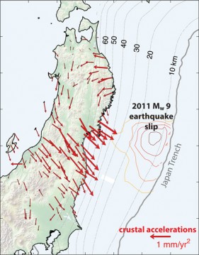
For decades leading up to the 2011 earthquake and tsunami that devastated the east coast of Japan, GPS stations on the island of Honshu recorded changes at the rate at which the Earth’s surface deformed. Previous work attributed this to the lasting effects of earlier earthquakes, such as the series of Mw 6.5+ events that struck between 2003 and 2011. Temblors can influence deformation long after shaking stops through gradual postseismic slip and, for large events, through decades-long relaxation of stress in the lower crust and mantle.
In a new study, Mavrommatis et al. tried to constrain the impact of historical earthquakes to determine if they might be masking any underlying trends. The researchers modeled the total deformation associated with previous seismic events, including several Mw 7.5+ earthquakes that occurred long before GPS monitoring of crustal velocities began, and compared their results with observations.
For the area north of the 2011 rupture, the researchers found that past earthquakes explained nearly all of the recent changes in the rate of deformation. However, adjacent to the rupture site, they detected continuously decreasing strain rates that appear to be unrelated to the region’s seismic history. This multidecadal trend may have begun sometime before 1996, prior to the establishment of the GPS network used in the study.
The researchers do not know exactly what drove the changes leading up to the 2011 earthquake, but they think they may be linked to changes in slip along the interface with the Pacific plate. Either increased slip rates at intermediate depths on the Japan Trench megathrust fault or a decrease in the depth at which a partially or fully locked plate interface gives way to smooth, aseismic creep could explain their observations.
Such long-duration changes in the rate of deformation before a huge megathrust earthquake have never been documented before. More research will reveal whether the authors’ observations represent a unique regional anomaly and whether the deformation helped dictate the timing of the 2011 earthquake. (Geophysical Research Letters, doi:10.1002/2014GL060139, 2014)
—Julia Rosen, Writer
© 2014. American Geophysical Union. All rights reserved.
© 2014. American Geophysical Union. All rights reserved.