
Source: Geophysical Research Letters
Each September, Arctic sea ice melts to a minimum point and then refreezes again over the winter. As a result of climate change, the Arctic is warming at a rate faster than the rest of the globe, causing more sea ice to melt during the summer than freezes in the winter.
The sea ice minimum has been diminishing by about 13% per decade since 1979 (and perhaps long before that) when scientists first started using satellites to track Arctic sea ice. The 2017 Arctic sea ice minimum was the eighth lowest on record, covering roughly 1.8 million square miles of the Earth’s surface.
Not only are low sea ice minimums a threat to wildlife, such as polar bears, but also they create a positive feedback loop: Ice is highly reflective, so when there’s less of it, sunlight is absorbed at the Earth’s surface instead of being reflected back into the atmosphere, causing more warming and thus more melt. Scientists have also found that fewer patches of sea ice are thick enough to survive multiple melt seasons, meaning that ice cover is getting thinner in general and more vulnerable to melting.
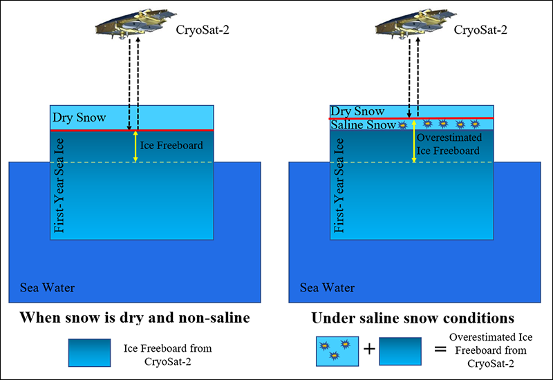
In 2010, the European Space Agency launched the CryoSat-2 satellite to estimate changes in the thickness and volume of polar sea ice. An antenna on the satellite transmits microwaves toward the Earth’s surface, and a receiver measures the time it takes the signal to be reflected back, determining whether the point below is ice or open water. If it’s ice, the microwaves can, in theory, penetrate first through the top of the snow cover to the surface of the ice, where they are reflected back to the satellite’s receiver. A bit of math then yields a value for the ice’s thickness.
Scientists who use CryoSat-2 data to estimate Arctic sea ice thickness generally assume that these signals are being reflected off of a flat plane of ice; however, it’s possible that layers of snow on top of the ice could introduce errors in their measurements. In particular, snow salinity—the amount of salt, traces of which are left behind during the freezing process, contained in the snow—could skew results by reflecting microwaves back to the satellite’s receiver from these salty snow layers before they reach the surface of the ice. This would cause the ice’s freeboard—the amount of ice above the seawater—to be overestimated.
In a new study, Nandan et al. explore the effect of snow salinity on the ability of satellite signals to penetrate through snow to the sea ice’s true surface. The team of researchers examined first-year ice measurements collected over the Canadian Arctic in late winter, using a mathematical model to determine the amount and distribution of salt in the snow.
On the basis of their modeling, the researchers found that snow salinity had the potential to throw off sea ice thickness estimates by 11%–25%, depending on sea ice thickness. They recommend that others account for this in the hope that doing so will improve the accuracy of future estimates, especially for first-year ice. (Geophysical Research Letters, https://doi.org/10.1002/2017GL074506, 2017)
—Sarah Witman, Freelance Writer
Citation:
Witman, S. (2017), Reducing errors in satellite-derived Arctic sea ice thicknesses, Eos, 98, https://doi.org/10.1029/2017EO087179. Published on 04 December 2017.
Text © 2017. The authors. CC BY-NC-ND 3.0
Except where otherwise noted, images are subject to copyright. Any reuse without express permission from the copyright owner is prohibited.