
On 19–20 June 2024, less than 2 days after the Salt and South Fork Fires ignited near Ruidoso, N.M., monsoon thunderstorms triggered flash flooding across the same area. The rainfall helped to extinguish the fires, which together burned roughly 100 square kilometers and displaced thousands of residents, but it also caused the first of 10 postfire flooding and debris flow events that plagued Ruidoso over the following months. These events led to travel disruptions; numerous swift water rescues; and damage to homes, buildings, roads, bridges, and vehicles.
In similar fashion, on 12 August 2024, less than a month after the Easy Fire ignited in Washington’s Northern Cascades, a thunderstorm triggered a debris flow that blocked a highway and impeded firefighting operations.
Incidents of compounded hazards caused by postfire precipitation are becoming increasingly common across western North America and around the world.
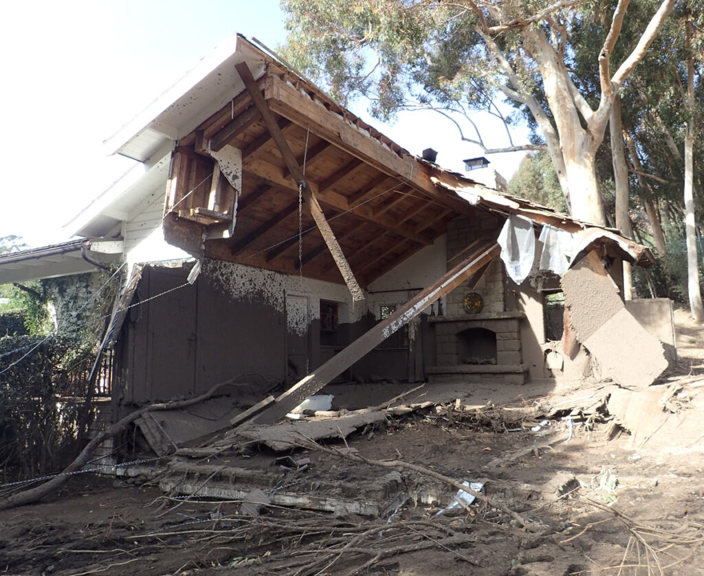
When a wildfire ignites, the focus of response efforts is often on immediate effects from fire, including destruction of homes and property, smoke pollution, loss of ecosystems and habitats, and releases of toxins into the environment. Yet incidents of compounded hazards caused by postfire precipitation are becoming increasingly common across western North America—and around the world—leaving communities recently affected by wildfire racing to prepare for flood and debris flow impacts before the next rainstorm. Fire-enhanced runoff and erosion can lead to hazards ranging from flooding to rockfalls; however, fast-moving postfire debris flows (PFDFs) are particularly hazardous to life, property, and infrastructure [Lancaster et al., 2021].
Debris flows are mixtures of water, mud, boulders, wood, and other debris that can exceed velocities of 10 meters per second—similar to the speeds of the fastest human sprinters—and exert substantial forces on anything in their path. Apart from their obvious threats to public safety, they can also, for example, bury roads under meters of debris and push thousands of cubic meters of sediment into rivers, negatively affecting water quality, aquatic habitats, and flow capacities. Heightened potential for PFDFs begins immediately after a wildfire starts and can persist for several years [McGuire et al., 2024].
During the past 2 decades, areas at risk from PFDFs have increased as wildfires have become larger, more severe, and more frequent worldwide because of climate warming [Oakley, 2021] and as homes, businesses, and infrastructure have expanded into the wildland-urban interface. With this risk growing, a better understanding of PFDFs is becoming more critical.
Defining pressing research questions about processes driving PFDFs and about their effects on the built environment will help researchers develop and improve operationally useful metrics, such as rainfall thresholds. A rainfall threshold offers a critical characterization of rainfall intensity that, when exceeded, indicates a high likelihood of debris flow. These metrics and similar tools and resources support decisionmakers who issue public warnings about postfire hazards and who coordinate emergency and mitigation efforts with limited resources.
In May 2024, a group of 91 government, academic, and practitioner scientists and engineers gathered to address PFDF needs at the Establishing Directions in Postfire Debris Flow Science Conference. By identifying major research and operation hurdles and prioritizing research objectives to address those hurdles, participants identified critical future directions for PFDF science.
Altered Landscapes, Heightened Hazards
Wildfire alters landscapes in ways that substantially increase the likelihood of debris flows.
Wildfire alters landscapes in ways that substantially increase the likelihood of debris flows above background rates, creating an acute hazard in areas where these flows are otherwise infrequent. Fire consumes vegetation and ground cover and decreases soil infiltration capacity [Ebel and Martin, 2017], making soil more susceptible to erosion and increasing runoff during storms [Cannon, 2001]. High-intensity rainfall is particularly effective at generating the magnitude of runoff needed to kick-start debris flows [Kean et al., 2011]. Such rainfall can result from thunderstorms or convection embedded in midlatitude weather systems [e.g., Oakley et al., 2017].
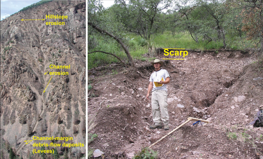
In burned areas, runoff-generated PFDFs initiate when sediment is rapidly eroded by water flowing down steep hillslopes and channels [Rengers et al., 2021] (Figure 1, left). In contrast, in unburned areas or on slopes several years or more after fire, shallow landslides are the primary drivers of debris flows. Shallow landslides initiate when water saturates soil and sufficiently decreases the frictional forces holding it in place on a hillslope. Whereas debris flows mobilized by saturation-induced shallow landslides leave telltale scarps at their initiation locations (Figure 1, right), runoff-generated debris flows, which are made up of sediment eroded from across the landscape, rarely have a single initiation point [Kean et al., 2013] (Figure 1, left).
Different Regions, Different Triggers
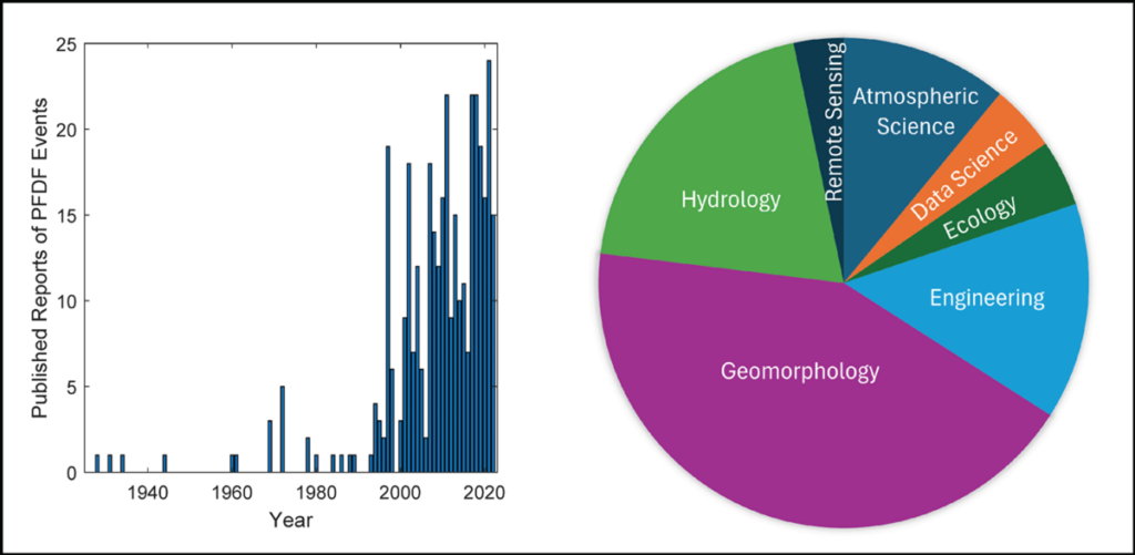
The May 2024 gathering of postfire debris flow scientists, engineers, and practitioners was motivated by increased PFDF activity in recent decades in western North America. However, observations of PFDFs have been documented since the early 20th century, with some of the earliest—from Southern California—published 90 years ago [e.g., Eaton, 1936]. Starting a few decades ago, PFDF research accelerated, and the science has evolved rapidly to encompass many fields (Figure 2).
Much progress has been made in this research. For example, we have learned that PFDFs are commonly initiated by runoff from short bursts of high-intensity rainfall over steep, burned slopes. These results have allowed researchers to develop observation-based, or empirical, models to help identify hazard areas. In the western United States, for example, empirical models are used to predict PFDF likelihood and volume using terrain attributes, soil erosivity, soil burn severity, and rainfall intensity [e.g., Gartner et al., 2014; Staley et al., 2017]. Similar models have been developed for other fire-prone regions around the world, such as southeastern Australia [e.g., Nyman et al., 2015].
Research has produced many insights into the mechanisms that influence the likelihood and magnitude of postfire debris flow hazards, but fundamental questions remain unanswered.
Although recent research has produced many insights into the mechanisms that influence the likelihood and magnitude of PFDF hazards, fundamental questions remain unanswered, further motivating the May 2024 conference. One question identified during the conference, for example, was how PFDF initiation mechanisms change across (and depend on) climatic, biotic, and geologic settings.
In recent years, drought has brought unusually large, high-severity wildfires to forested areas of western Canada and the U.S. Pacific Northwest. Growing evidence indicates that contrary to burn areas in semiarid regions, runoff from high-intensity rainfall may not be the main driver of PFDFs in that region. Rather, PFDFs may more commonly initiate from shallow landslides and gravity-driven failures of channel material resulting from long-duration rainfall or rain-on-snow and snowmelt events that saturate the soil.
Fire activity is also increasing in some of the drier regions of North America, with implications for PFDFs. In the Sonoran Desert, where invasive grasses have helped feed recent large wildfires, runoff from high-intensity rainfall is the main driver of PFDFs, although rainfall thresholds for debris flow initiation are greater relative to those of nearby forest and chaparral ecosystems.
Priorities for Postfire Debris Flow Science
Participants at the May 2024 meeting discussed the state of PFDF science and research. The group identified and voted on 10 priorities for advancing the field (Figure 3), then further discussed tangible products and activities to advance the top three of those.
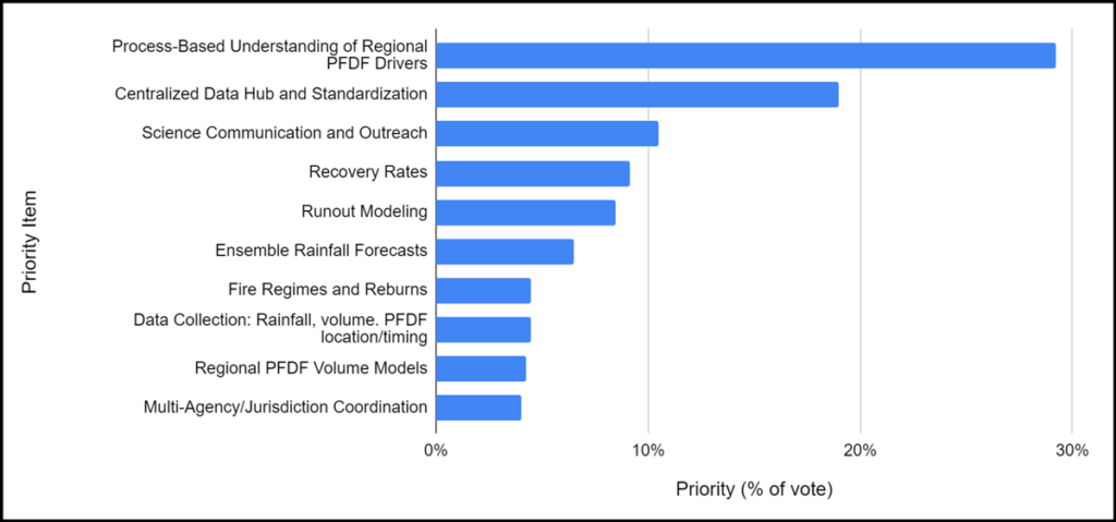
The first of these consensus priorities is more research into how and why different processes drive PFDFs in different geographic and climatic regions. Identifying and understanding these different regional drivers are critical for developing generalizable models of PFDF hazards—or a suite of regionally appropriate models—as well as rainfall thresholds and related operational products such as models for rapidly assessing debris flow volume and runout. These products can, in turn, help guide efforts to raise PFDF hazard awareness, design effective mitigation strategies, and improve early-warning systems.
In situ monitoring of debris flows across a range of geographic and climatic regions could help meet research needs.
In situ monitoring of debris flows across a range of geographic and climatic regions, including areas where fire is emerging as a catalyst for debris flow activity, could help meet this research need. In the United States, the group consensus around this idea is supported by the National Landslide Preparedness Act, which was passed in 2021 and calls for an expansion of early-warning systems for PFDFs.
The second priority is to establish a centralized data hub to support research into PFDF processes and hazards. Currently, PFDF data are collected by individual agencies and research groups with their own protocols and stored in a variety of formats that may not be easily shared. Adopting standardized data collection procedures and formats in a centralized hub would provide reliable, consistent, and accessible data useful for gaining new insights and for developing and testing models, which could accelerate research across the range of priorities identified (Figure 3).
Next steps toward developing this data hub include creating a task force to work with potential contributors to establish protocols and to identify funding sources and potential hosts for the hub. Similar active data hubs that may serve as models include the National Centers for Environmental Information for global climate, terrestrial, and natural hazards data and EarthScope for seismic data.
Recognizing that the geographic areas subject to PFDF hazards are expanding, the third priority identified is improved communication, outreach, and education about these hazards by scientists. Such efforts can provide actionable information to decisionmakers and emergency managers regarding the triggers, potential effects, and mitigation strategies of PFDFs and will require relationship building by PFDF scientists to facilitate the two-way knowledge transfer. These efforts can also involve translating research findings into operational guidelines and products, providing plain language information to assist communities in hazard areas, and explaining the implications of research results for policy development and land management.
Collaboration Through Community Building
It will take a community of scientists, emergency management experts, policymakers, and community leaders to understand, address, and ensure safety from the expanding hazard of PFDFs across varying climatic, geographic, and ecological regions. Boundary organizations are well suited for bringing such groups together to establish a common understanding of complex issues and consensus around goals.
Boundary organizations such as the Joint Fire Science Program Fire Science Exchange Network (FSEN) help foster knowledge exchange and implementation of fire science information across agencies and disciplines. The California Fire Science Consortium (CFSC), one of 15 regional FSENs, facilitated the May conference, which laid the foundation for future collaborations, including the new Interagency Post-fire Integration Council.
Through its discussions, this group highlighted the highest-priority needs for PFDF science and established directions for ongoing research. By focusing on improving our understanding of regional PFDF drivers, creating a centralized data hub, fostering accessible and actionable science communication, and other identified priorities, we can reduce risks from PFDFs to communities in the Desert Southwest, the Pacific Northwest, and elsewhere around the world.
Acknowledgments
The authors gratefully acknowledge the U.S. Geological Survey for funding the conference described above, CFSC for its support in planning and running the conference, and the conference attendees for their participation. The authors also gratefully acknowledge fellow conference coconveners: Katanja Waldner of CFSC, Derek Cheung of the California Geological Survey, and Emily Wells of the Cooperative Institute for Research in the Atmosphere at Colorado State University and NOAA Global Systems Laboratory. Any use of trade, firm, or product names is for descriptive purposes only and does not imply endorsement by the U.S. government.
References
Cannon, S. H. (2001), Debris-flow generation from recently burned watersheds, Environ. Eng. Geosci., 7(4), 321–341, https://doi.org/10.2113/gseegeosci.7.4.321.
Eaton, E. C. (1936), Flood and erosion control problems and their solution, Trans. Am. Soc. Civ. Eng., 101(1), 1,302–1,330, https://doi.org/10.1061/TACEAT.0004726.
Ebel, B. A., and D. A. Martin (2017), Meta-analysis of field-saturated hydraulic conductivity recovery following wildland fire: Applications for hydrologic model parameterization and resilience assessment, Hydrol. Processes, 31(21), 3,682–3,696, https://doi.org/10.1002/hyp.11288.
Gartner, J. E., S. H. Cannon, and P. M. Santi (2014), Empirical models for predicting volumes of sediment deposited by debris flows and sediment-laden floods in the transverse ranges of Southern California, Eng. Geol., 176, 45–56, https://doi.org/10.1016/j.enggeo.2014.04.008.
Kean, J. W., D. M. Staley, and S. H. Cannon (2011), In situ measurements of post-fire debris flows in Southern California: Comparisons of the timing and magnitude of 24 debris-flow events with rainfall and soil moisture conditions, J. Geophys. Res. Earth Surf., 116(F4), F04019, https://doi.org/10.1029/2011JF002005.
Kean, J. W., et al. (2013), Runoff-generated debris flows: Observations and modeling of surge initiation, magnitude, and frequency, J. Geophys. Res. Earth Surf., 118(4), 2,190–2,207, https://doi.org/10.1002/jgrf.20148.
Lancaster, J. T., et al. (2021), Observations and analyses of the 9 January 2018 debris-flow disaster, Santa Barbara County, California, Environ. Eng. Geosci., 27(1), 3–27, https://doi.org/10.2113/EEG-D-20-00015.
McGuire, L. A., et al. (2024), Fire effects on geomorphic processes, Nat. Rev. Earth Environ., 5(7), 486–503, https://doi.org/10.1038/s43017-024-00557-7.
Nyman, P., et al. (2015), Predicting sediment delivery from debris flows after wildfire, Geomorphology, 250, 173–186, https://doi.org/10.1016/j.geomorph.2015.08.023.
Oakley, N. S. (2021), A warming climate adds complexity to post-fire hydrologic hazard planning, Earth’s Future, 9(7), e2021EF002149, https://doi.org/10.1029/2021EF002149.
Oakley, N. S., et al. (2017), Synoptic conditions associated with cool season post-fire debris flows in the Transverse Ranges of Southern California, Nat. Hazards, 88, 327–354, https://doi.org/10.1007/s11069-017-2867-6.
Rengers, F. K., et al. (2021), Movement of sediment through a burned landscape: Sediment volume observations and model comparisons in the San Gabriel Mountains, California, USA, J. Geophys. Res. Earth Surf., 126(7), e2020JF006053, https://doi.org/10.1029/2020JF006053.
Staley, D. M., et al. (2017), Prediction of spatially explicit rainfall intensity–duration thresholds for post-fire debris-flow generation in the western United States, Geomorphology, 278, 149–162, https://doi.org/10.1016/j.geomorph.2016.10.019.
Author Information
Ann M. Youberg ([email protected]), Arizona Geological Survey, University of Arizona, Tucson; Luke A. McGuire, Department of Geosciences, University of Arizona, Tucson; Nina Oakley, California Geological Survey, Sacramento; Francis K. Rengers, Geologic Hazards Center, U.S. Geological Survey, Golden, Colo.; and Autym Shafer, California Fire Science Consortium, Berkeley