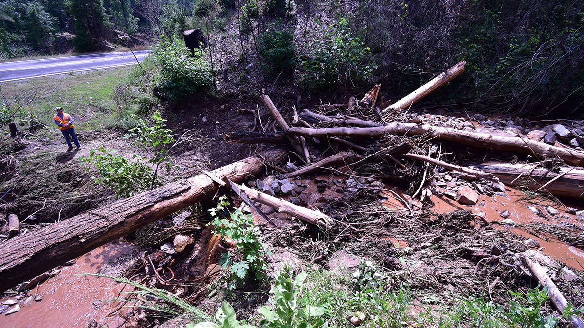

High in the Sierra Nevada, land across several Northern California counties still bears scars from the 2021 Dixie Fire, which raged for months and burned 3,900 square kilometers, becoming the largest single fire in the state’s history. On those ravaged slopes, even brief downpours of intense rainfall could send exposed soils and rocks careening down the mountain in destructive, potentially deadly debris flows.
Forecasting when and where such flows might strike is vital to public safety. U.S. Geological Survey models suggest that burned slopes with steep grades and loose sediments are much more likely to experience postfire debris flows during intense storms. But rains in June 2023 revealed shortcomings in the models’ predictive ability.
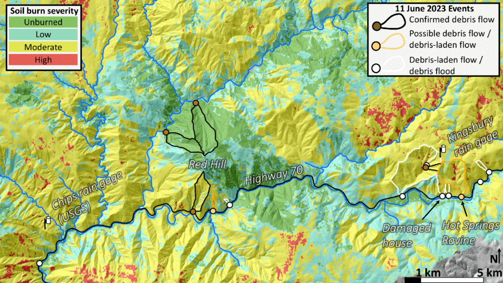
On 10 June, high precipitation rates upward of 30 millimeters per hour in one such burned zone, Kingsbury Ravine, triggered no debris flows, although a slope in the ravine failed the next day when more rains arrived. Also on 11 June, three debris flows occurred on Red Hill, roughly 15 kilometers west of Kingsbury Ravine, the two largest of which were in basins that fire hadn’t touched. Meanwhile, other nearby burned basins saw no flows.
“When things break down, there are great opportunities to figure out what happened and why.”
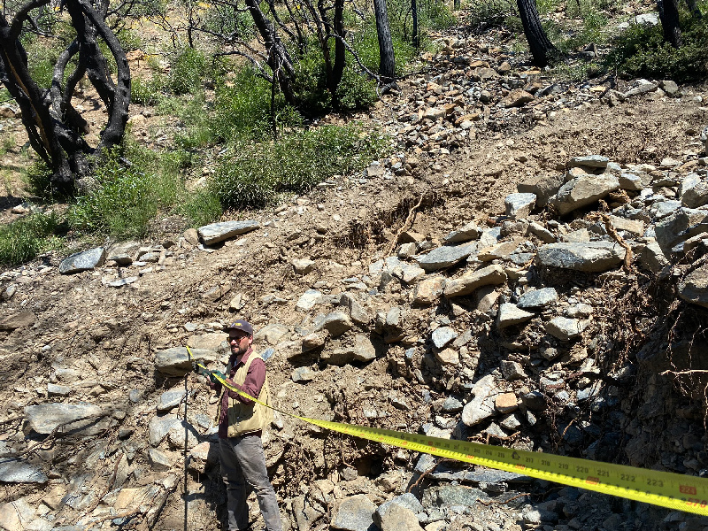
Soon after, a team from the California Geological Survey’s (CGS) Burned Watershed Geohazards Program took to the field to investigate this perplexing pattern of events. “When things break down, there are great opportunities to figure out what happened and why,” said Paul Richardson, a staff engineering geologist on the team.
Current debris flow models for the state are based on data from Southern California, so the researchers saw the unexpected June events as a chance to investigate factors contributing to flows in the distinct landscapes of Northern California. The researchers presented their work at AGU’s Annual Meeting 2023.
Unpredictable Weather Patterns
Heavy, short-duration rains are the main trigger for postfire debris flows. For that reason, rainfall monitoring and reliable forecasts are keys to predicting which slopes are at highest risk. But the summer storms that often trigger these flows are patchy, and installing enough rain gauges to provide detailed monitoring across landscapes can be challenging. With such constraints, it’s possible that peak outbursts of rain go undetected, even if a rain gauge is just a few kilometers away.
To supplement field measurements, the CGS researchers looked to data from NOAA’s Multi-Radar/Multi-Sensor (MRMS) system, which integrates data from multiple radars, satellites, field observations, and models to help predict weather patterns. At Kingsbury Ravine, the rain gauge recorded especially high precipitation rates, which the broader-scale MRMS data did not reflect. That meant the heavy rains detected by the gauge were likely highly localized, potentially explaining why slopes in the ravine were stable one day but then a debris flow occurred the next day.
“It’s at the cutting edge to do this [combined climate monitoring] at the hourly and subhourly levels,” said Nina Oakley, a climatologist on the team. And as tools like MRMS develop, researchers will be able to form a more complete picture of what’s happening in the field.
Signatures in the Earth
Scorched areas are more susceptible to debris flows, but any slope can fail under certain conditions.
Scorched areas are more susceptible to debris flows, but any slope can fail under certain conditions. Unlike the burned basins around it, Red Hill is underlain by ultramafic rock from Earth’s mantle that was brought to the surface as the Sierra Nevada rose. The soil atop this ultramafic rock isn’t hospitable to a lot of plants, so vegetation is sparse on Red Hill, making it easier for the soils to mobilize during heavy rains.
Even more telling are geomorphic signatures on slopes: Scientists can use evidence of ancient floods and flows preserved in today’s rocks and soils to pinpoint likely zones of weakness. The CGS team observed such imprints within and near the Dixie Fire burn scar area using a factor that reflects the kinds of flows an area has experienced over tens of thousands of years. The factor describes how locations along channels transition from being debris flow dominated to being fluvially dominated.
Geomorphologist Luke McGuire of the University of Arizona, who was not involved in the research, was surprised by this aspect of the team’s work. “I’ve never seen [that factor] employed in this way,” he said. McGuire said it’s unclear how useful such assessments of past activity might be on their own, but “it’s definitely worth exploring in combination with other variables that are more related to what’s happening here and now.”
In continuing work, the researchers plan to track other factors that contribute to postfire slope failures, such as streamflows, vegetation recovery, and sediment availability. “There’s a pretty serious data gap here,” said Don Lindsay, a geotechnical engineer on the team. “We’re making an effort to infill that data gap, expand our knowledge, and improve science.”
—Eli Ramos (@mxeliramos), Science Writer