North America’s largest earthquakes and most powerful volcanic eruptions occur along the Alaska Peninsula subduction zone, a meeting of two tectonic plates that sweeps an arc across the North Pacific margin between Alaska and Russia. However, studies that would help us understand these hazards are few and far between in this remote, sparsely populated region.
A major shoreline-crossing community seismic experiment, now under way, spans the Alaska Peninsula subduction zone, with the intention of filling gaps in our knowledge of this region. Information that we collect along this margin can provide direct information about many first-order questions about subduction zone processes that influence earthquakes and volcanism.
“Historically, geophysical data collection has been challenging in Alaska.”
For example, segments that have generated great earthquakes (M > 9) behave very differently from segments that are smoothly creeping, and various arc segments have fundamentally different volcano chemistry. If we can understand how geologic structures or material properties contribute to this segmentation, then we should be able to better forecast the long-term rates and effects of major geological events.
Historically, geophysical data collection has been challenging in Alaska because of difficult logistics; low population density; and, like most subduction zones, the challenge of extending comprehensive studies offshore to include the fore arc and subducting plate. The Alaska Amphibious Community Seismic Experiment (AACSE) has deployed an amphibious seismic array, designed by the scientific community, to make major advances on these problems. This array is recording earthquakes and other events in the Alaska subduction system as well as globally. All these data will be made available openly as rapidly as possible, to make it as easy as possible for scientists around the world to become involved.
An Amphibious Array
AACSE deployed an array of 75 broadband ocean bottom seismometers (OBSs) and 30 onshore broadband seismometers for 15 months, starting in May 2018 (Figure 1). The array covers an along-strike segment of the subduction zone spanning some 650 kilometers, including the Alaska Peninsula and Kodiak Island, and it extends about 250 kilometers seaward from the trench.

The array densifies and expands offshore the EarthScope Transportable Array, a major community experiment that is running concurrently. This is a golden age for instrumental seismology in Alaska with the full deployment of the Transportable Array, AACSE, and several other projects.
A critical part of AACSE is its amphibious nature: tight integration of onshore and offshore observational campaigns.
AACSE stems in part from a 2014 workshop on the future of amphibious seismology and in part from science plans for two National Science Foundation research programs, Geodynamic Processes at Rifting and Subducting Margins (GeoPRISMS) and EarthScope. In different ways, both of these decadal programs have a strong focus on understanding subduction systems, and both use North America as a natural laboratory for fundamental discovery. The AACSE project also builds on valuable lessons learned from the Cascadia Initiative, a 4-year series of linked OBS deployments farther south, across and around the Juan de Fuca and Gorda plates, in which much of the AACSE instrumentation was developed [Toomey et al., 2014].
A critical part of AACSE is its amphibious nature: tight integration of onshore and offshore observational campaigns. Virtually all subduction systems on Earth span the shoreline, from deep submarine trenches to large subaerial volcanoes (i.e., volcanoes that erupt into the air rather than in water). Consequently, subduction systems call for observational approaches that extend onshore and at sea. However, science planning and funding often place artificial barriers at the shoreline, making truly amphibious projects rare. The AACSE program has worked hard to leverage resources from NSF’s terrestrial (Division of Earth Sciences) and marine (Division of Ocean Sciences) programs, and it has focused on integrated planning at every step.
A Community Experiment
AACSE is a “community” project in several ways. First, all data from the project will be openly accessible to any interested scientist as soon as they are recovered from the field and formatted for archiving. All seismograms will be available at the Incorporated Research Institutions for Seismology (IRIS) Data Management Center, which handles a wide range of seismic data and data access platforms. Other data will be housed in appropriate data centers for their data types; for instance, shipboard data are at the Marine Geoscience Data System. The AACSE web page has specifics on the program and data access.
Second, the experimental planning, design, and participation have been kept as open as possible. A large planning meeting in 2014 evaluated a wide variety of scientific targets, followed by several Web-based forums, open calls for principal investigator participation, and public comment periods once draft deployment designs were crafted.
Third, the project engages and trains the next generation of scientists by teaching them the skills required for work with amphibious data sets. Each deployment or recovery cruise includes multiple early- to middle-career scientists without prior marine experience. Cruise participants range from graduate students to faculty to geoscience professionals to Alaskan high school science educators, all of whom gained invaluable direct experience with data collection. In these ways, AACSE provides a major new data set and helps build the community that can make use of it, maximizing the potential impact of this community resource.
The 2018 Deployment
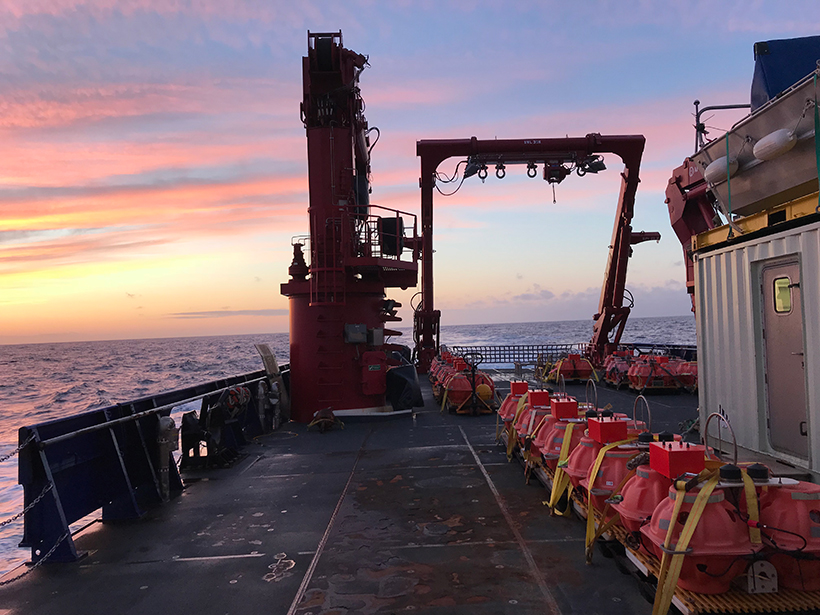
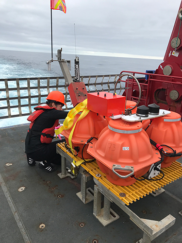
The heart of the AACSE project is a network of 105 broadband seismometers and numerous accelerometers, seafloor pressure gauges, and temperature sensors deployed every 20–50 kilometers along the seafloor and on land. We deployed 75 ocean bottom seismometers on two cruises on the R/V Sikuliaq, sailing from the home port of Seward, Alaska, with support from OBS facilities at the Lamont-Doherty Earth Observatory of Columbia University and the Woods Hole Oceanographic Institution. Twenty of the OBSs have trawl-resistant mounts especially designed for shallow water, protected against bottom trawling, and designed to dampen wave and current noise (Figure 2). Five of these OBSs have accelerometers to record nearby strong earthquakes.
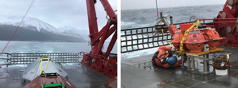
In parallel with the marine expeditions, ground teams deployed 30 broadband land stations on Kodiak Island, the Alaska Peninsula, and the Shumagin Islands, using a variety of small planes, boats, and wheeled vehicles to reach critical locations in this remote region. These instruments, provided by the IRIS Portable Array Seismic Studies of the Continental Lithosphere (PASSCAL) Instrument Center, feature broadband seismic sensors designed for postholes, and six include accelerometers. The distribution of the onshore stations was designed to complement the marine deployment, the sparse permanent networks in this region, and the EarthScope Transportable Array. All broadband sensors have 120-second response corners, and they collect data continuously at a frequency of 100 hertz.

In 2019, AACSE plans to deploy a dense array of several hundred 5-hertz, three-component “nodal” seismometers across the road system on Kodiak, which sits atop the rupture zone of the great (M9.2) 1964 Alaska earthquake. This relatively new technology adopted from the petroleum industry allows significant oversampling of the high-frequency wavefield to enable high-resolution studies of the thrust zone structure and associated microearthquakes.
The community nature of AACSE has also inspired a series of side projects and follow-on projects, including deployments of seafloor GPS-acoustic stations, next-generation absolute pressure gauges, seafloor temperature observations linking to the water column above, and subseafloor electromagnetic imaging.
A 15-Month Snapshot
The 15-month deployment of AACSE stations will represent one of the longest large-scale multi-instrument amphibious seismic deployments to date.
The 15-month deployment of AACSE stations will represent one of the longest large-scale multi-instrument amphibious seismic deployments to date. The instrument centers that engineered the OBSs designed them to accommodate a two-summer deployment duration specifically for this experiment.
Even this extended deployment time provides only a snapshot of the earthquake cycle, but chances are good that this snapshot will capture something of interest. The Alaska Peninsula region generates earthquakes at very high rates and from different sources: along the plate boundary interface, within the downgoing plate, and within the overriding fore-arc crust.
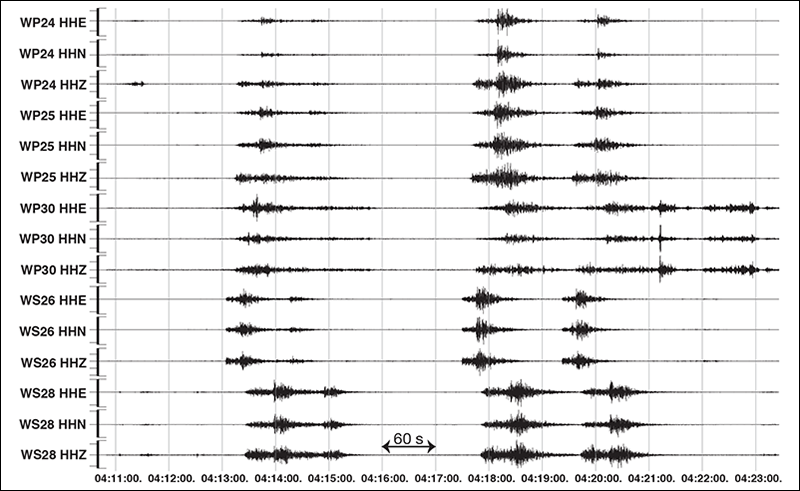
In the first 3 months of the AACSE deployment, the Shumagin region has already experienced several swarms of earthquakes, including many M > 5 events, and other large events (M4–5) have happened north of Kodiak Island and within the central Semidi segment (e.g., Figure 3). At the far eastern extent of the array, an ongoing aftershock sequence of the January 2018 magnitude 7.9 earthquake within the Pacific plate is also being recorded at close range using offshore instruments. Collectively, this experiment promises to record abundant seismic activity, which should provide new insight into earthquake source properties and serve as a source for local geophysical imaging.
Integrating Observations on Land and Sea
The capability to deploy large arrays at sea has existed only for the past few years, yet the most seismogenic places are largely offshore or cross coastlines.
Although broadband array seismology has greatly advanced our understanding of Earth beneath continents since the early 1990s, the capability to deploy large arrays at sea has existed only for the past few years. Yet the most seismogenic places are largely offshore or cross coastlines, and understanding the 60% of Earth beneath oceanic crust can be done only from the seafloor. The AACSE opportunity is a major advance in addressing these challenges with new and emerging technologies.
Information on AACSE, including regular updates on progress and participation opportunities, is available at the project’s GeoPRISMS-hosted website. AACSE data are archived at the IRIS Data Center, under network codes XO for onshore sites and XD for OBSs.
Acknowledgments
AACSE is supported by National Science Foundation award OCE-1654568, with instrumentation and data management support from IRIS and the Ocean Bottom Seismometer Instrument Center. We thank R. Danforth for bathymetric figure production, the many support staff onshore and on the R/V Sikuliaq, and the apply-to-sail participants who made this deployment possible.
References
Toomey, D. R., et al. (2014), The Cascadia Initiative: A sea change in seismological studies of subduction zones, Oceanography, 27(2), 138–150, https://doi.org/10.5670/oceanog.2014.49.
Author Information
G. A. Abers ([email protected]), Department of Earth and Atmospheric Sciences, Cornell University, Ithaca, N.Y.; A. N. Adams, Department of Geology, Colgate University, Hamilton, N.Y.; Peter J. Haeussler, U.S. Geological Survey, Anchorage, Alaska; Emily Roland, School of Oceanography, University of Washington, Seattle; P. J. Shore and Douglas A. Wiens, Department of Earth and Planetary Sciences, Washington University in St. Louis, Mo.; Susan Y. Schwartz, Department of Earth and Planetary Sciences, University of California, Santa Cruz; Anne F. Sheehan, Department of Geological Sciences, University of Colorado Boulder; D. J. Shillington and Spahr Webb, Lamont-Doherty Earth Observatory, Columbia University, Palisades, N.Y.; and Lindsay L. Worthington, Department of Earth and Planetary Sciences, University of New Mexico, Albuquerque
Citation:
Abers, G. A.,Adams, A. N.,Haeussler, P. J.,Roland, E.,Shore, P. J.,Wiens, D. A.,Schwartz, S. Y.,Sheehan, A. F.,Shillington, D. J.,Webb, S., and Worthington, L. L. (2019), Examining Alaska’s earthquakes on land and sea, Eos, 100, https://doi.org/10.1029/2019EO117621. Published on 26 March 2019.
Text © 2019. The authors. CC BY-NC-ND 3.0
Except where otherwise noted, images are subject to copyright. Any reuse without express permission from the copyright owner is prohibited.