
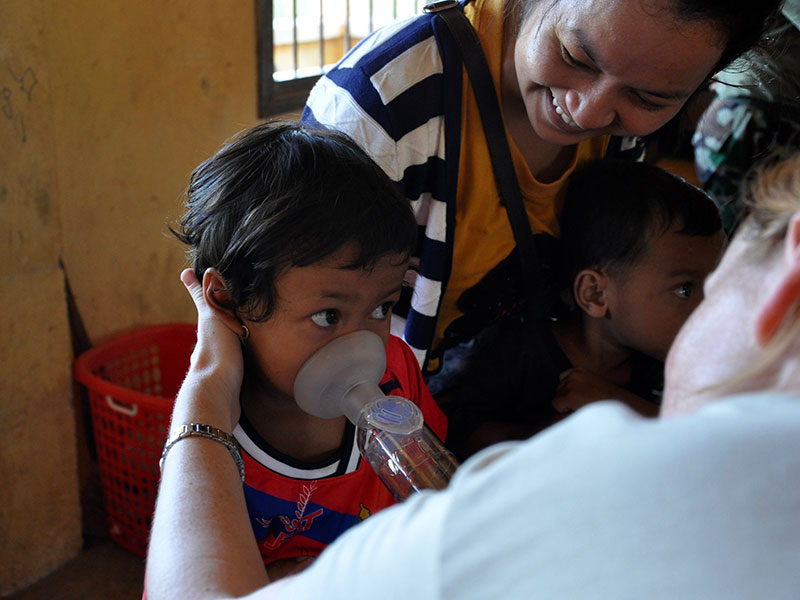
Every year, plants around the world burst into bloom, producing a spectacular display of color—and releasing an abundance of pollen. For people with asthma and other respiratory ailments, springtime heralds the beginning of a season of misery.
Asthma affects more than 319 million individuals globally. In the United States, nearly 8% of the population currently suffers from asthma, costing more than $80 billion annually in treatment and loss of productivity [Nurmagambetov et al., 2018]. Despite this high health care cost and the real suffering of those with allergies, pollen monitoring in the United States that could help reduce necessary treatments and lost time remains limited. However, satellites that monitor plant activity are poised to play a major role in a coordinated effort to generate localized pollen forecasts, which could help millions of people breathe easier.
Pollen Information from Three Sources
The Interagency Working Group on Climate Change and Health concluded that climate change will likely amplify existing environmental triggers of asthma, resulting in more severe and frequent exacerbations, particularly among vulnerable populations [Portier et al., 2010]. Although pollen is one of the leading risk factors known to worsen asthma symptoms, pollen monitoring in the United States is often undertaken by a private network of physicians with no governmental support. Because of the high labor cost associated with pollen counting, there were only 82 National Allergy Bureau–certified pollen counting stations in 2012, translating to one pollen monitor for every 3.4 million Americans.
Recent advances in Earth observations could support human health interventions by addressing the paucity of information on pollen presence, makeup, and concentration. Satellite-borne sensors, such as those on the Landsat missions, have the potential to provide remotely sensed information regarding the annual variability, spatial extent, and seasonality (start, peak, and end) of pollen patterns. Proxy data related to pollen dynamics generated from this information can also be used to identify the onsets and durations of seasons for important types of pollen.

In addition, near-surface images collected hourly from cameras on towers in the PhenoCam Network, currently comprising hundreds of sites worldwide, can supplement satellite-derived data. The thousands of observations collected and reported on a daily basis by participants in crowdsourced science programs like the USA National Phenology Network’s Nature’s Notebook program can provide still further information on the life cycle status of plants across the country, verifying information provided by satellite- and tower-based sensors.
Our recent work has shown that satellite-based phenology data can reveal information about the likelihood of asthma hospitalization risk at the local level, which is projected to be further exacerbated by climate change.
These different types of observations are complementary and, combined, offer pictures that are both overarching and locally detailed. Together, these resources would also provide more insight than we can currently gather into the taxonomy, or identities, of plants that contribute pollen during different life cycle stages (i.e., greening, flowering, senescing) over the course of the pollen season.
In particular, our recent work has shown that satellite-based phenology data can reveal information about the likelihood of asthma hospitalization risk at the local level [Sapkota et al., 2020], which is projected to be further exacerbated by climate change. This work highlights the substantial potential benefits of integrating these data sets and delivering information to clinicians, public health practitioners, and the public to improve decisions regarding management of pollen allergy symptoms, especially for vulnerable segments of the population.
Bridging Gaps Between Science and Health

Researchers recently convened a workshop involving physicians who treat allergic diseases, public health officials, and experts in remote sensing and ecology. The goals of the workshop were to assess the potential to bridge information gaps among scientists, health care professionals, and the public using Earth observations and to gauge interest in joining collaborations to address this multidisciplinary scientific and technical challenge. Participants confirmed their interest in working together and agreed on the need for better information about seasonal pollen patterns, including on the start of pollen season and the timing of peak pollen levels. This information could dramatically improve the timing of advice that clinicians and public health practitioners can provide to individuals suffering from pollen-related allergies and asthma, such as about updating prescriptions, purchasing over-the-counter medications, and modifying outdoor activity.
Participants also agreed that several important shortcomings exist in currently available information, including the lack of reliable near-real-time pollen measurements and data-driven short-term projections of pollen concentrations for use in advising patients. However, there are opportunities to leverage existing data sources to improve allergy warnings and advisories in the short term (days to months).
First, PhenoCam images and volunteer-contributed, ground-based phenology observations could be used to develop a simple location-specific indicator for the pollen onset and severity. Such an indicator could help fill gaps in pollen information at local to global scales; however, the PhenoCam Network is still evolving and adding new stations, so it may take time before its full potential for generating high-resolution data at a global scale is realized.
Second, existing satellite observations could be leveraged to estimate the start and timing of peak concentrations for the most allergenic taxonomic groups, including trees in spring and, to a lesser extent, grasses in summer and weeds in fall. These estimates would provide health practitioners with substantially more information than is currently available. This capability to obtain reliable pollen information from satellite observations has been demonstrated for birch (Betula), a highly allergenic species, and it has the potential to be extended to many more plant species [Karlsen et al., 2008; Li et al., 2019a]. PhenoCam observations and data from pollen monitoring networks and volunteer-based observations are valuable in verifying the efficacy of these space-based observations for deriving phenology indicators and vegetation-specific onset, duration, and intensity of pollen production [Khwarahm et al., 2017; Li et al., 2019b].
Third, determining the drivers of pollen development and release opens the door to producing real-time and short-term projections of airborne pollen for key pollen species. These projections are invaluable to allergy health experts and practitioners and to public health authorities.
Advancing Understanding of Pollen Dynamics and Early Warnings
Supporting these advancements that will support development of early-warning systems requires additional research in several areas. First, there is a need to develop predictive models for ground-level pollen that leverage satellite data, PhenoCam observations, and crowdsourced phenology data to fill information gaps between sparse pollen monitoring stations. Next, there is a need to improve our understanding and knowledge of the ways that different pollen types are related to allergic asthma symptoms based on demography, gender, and socioeconomic conditions, especially in rapidly developing urban systems around the world. Likewise, there is a need to improve our understanding of how pollen may synergistically interact with other known risk factors of asthma—such as air pollution (e.g., from ozone and particulate matter) and extreme heat—to worsen asthma symptoms.
Recent studies demonstrate the feasibility of using satellite-based phenology information together with asthma allergy hospitalization data to derive information useful to allergy health experts, practitioners, and policy makers [Sapkota et al., 2019, 2020]. There is an urgent need to evaluate the efficacy of such an approach for a wide range of systems, environmental conditions, vegetation types, and demographic populations in urban, suburban, and rural settings.
Finally, rethinking clinician education and training experiences can provide additional opportunities to improve patient care related to asthma and allergies. Allergy experts participating in our discussion noted the absence of environmental health topics in medical school curricula. They indicated that this gap impedes efforts to incorporate considerations of environmental change–related hazards and risks in day-to-day patient care.
Science Serving Society
To ensure healthy people and a healthy planet and in the spirit of science and technology serving society, environmental scientists, public health experts, and physicians must work together to incorporate such emerging technologies to tackle scientific challenges and improve health and well-being.
There are many opportunities to use existing technologies and data sets to better anticipate human allergenic responses to various factors in the environment. To ensure healthy people and a healthy planet and in the spirit of science and technology serving society, environmental scientists, public health experts, and physicians must work together to incorporate such emerging technologies to tackle scientific challenges and improve health and well-being.
Through an initial conversation involving public health officials and physicians who treat allergic diseases, we set the stage for progress on developing and delivering more actionable information regarding the risk for asthma and allergic responses in humans. We are excited by the prospects of advancing this multidisciplinary field by bringing together experts in public health, ecology, Earth observations, information science and technology, and public science networks to focus on a critical challenge. We hope to fulfill information needs for public health and to improve quality of life for people around the world who are vulnerable to pollen allergies.
References
Karlsen, S. R., et al. (2008), A satellite-based map of onset of birch (Betula) flowering in Norway, Aerobiologia, 25, 15, https://doi.org/10.1007/s10453-008-9105-3.
Khwarahm, N. R., et al. (2017), Mapping the birch and grass pollen seasons in the UK using satellite sensor time-series, Sci. Total Environ., 578, 586–600, https://doi.org/10.1016/j.scitotenv.2016.11.004.
Li, X., et al. (2019a), Characterizing the relationship between satellite phenology and pollen season: A case study of birch, Remote Sens. Environ., 222, 267–274, https://doi.org/10.1016/j.rse.2018.12.036.
Li, X., et al. (2019b), A dataset of 30 m annual vegetation phenology indicators (1985–2015) in urban areas of the conterminous United States, Earth Syst. Sci. Data, 11, 881–894, https://doi.org/10.5194/essd-11-881-2019.
Nurmagambetov, T., R. Kuwahara, and P. Garbe (2018), The economic burden of asthma in the United States, 2008–2013, Ann. Am. Thorac. Soc., 15(3), 348–356, https://doi.org/10.1513/AnnalsATS.201703-259OC.
Portier, C. J., et al. (2010), A human health perspective on climate change: A report outlining the research needs on the human health effects of climate change, report, Environ. Health Perspect. and Natl. Inst. of Environ. Health Sci., Research Triangle Park, N.C., www.niehs.nih.gov/climatereport.
Sapkota, A., et al. (2019), Associations between alteration in plant phenology and hay fever prevalence among US adults: Implication for changing climate, PLoS ONE, 14(3), e0212010, https://doi.org/10.1371/journal.pone.0212010.
Sapkota, A., et al. (2020), Association between changes in timing of spring onset and asthma hospitalization in Maryland, JAMA Network Open, 3(7), e207551, https://doi.org/10.1001/jamanetworkopen.2020.7551.
Author Information
Ghassem R. Asrar, Universities Space Research Association, Columbia, Md.; Yuyu Zhou, Department of Geological and Atmospheric Sciences, Iowa State University, Ames; Theresa M. Crimmins ([email protected]), USA National Phenology Network, Tucson, Ariz.; and Amir Sapkota, School of Public Health, University of Maryland, College Park
Citation:
Asrar, G. R.,Zhou, Y.,Crimmins, T. M., and Sapkota, A. (2020), Eyes in the sky improve pollen tracking, Eos, 101, https://doi.org/10.1029/2020EO147021. Published on 20 July 2020.
Text © 2020. The authors. CC BY-NC-ND 3.0
Except where otherwise noted, images are subject to copyright. Any reuse without express permission from the copyright owner is prohibited.