
Cities around the world face numerous environmental hazards—extreme heat, flooding, landslides, pollution, and harmful algal blooms to name a few—that they must monitor and address to reduce risk to their residents. One way to help keep city officials informed about these hazards is to invest in dense urban monitoring networks: arrays of sensors on and in the ground that provide continuous streams of diagnostic data [Bai et al., 2018].
However, in situ monitoring networks by themselves do not provide cities with sufficient information to make sound decisions on either short or long (i.e., climate change) timescales. These networks may struggle to keep up with rapid population shifts or growth, in part because people can quickly migrate across officially recognized city boundaries. And in less developed countries, dense urban monitoring networks are unlikely to be economically feasible or to cover informally settled areas adequately [Miller and Small, 2003]. Further, data from these monitoring networks alone cannot predict future environmental conditions.
Meanwhile, the spatial and temporal resolution of satellite-based products and Earth system models is progressively increasing. State-of-the-art Earth observations from these products can be used to map, monitor, and forecast many aspects of the urban environment. Urban-scale remote sensing is increasingly common in the research community [Creutzig et al., 2019]. Likewise, complex Earth system models are being used to understand the evolution of urban environments on longer timescales: The Urban Climate Change Research Network (UCCRN) recently released its second report on climate change in cities [Rosenzweig et al., 2018], for example, and the Intergovernmental Panel on Climate Change is incorporating an urban research agenda into its next assessment cycle.

In light of the increasing proportion of the global population that lives in cities [United Nations, 2019], the shared goal of making cities “inclusive, safe, resilient and sustainable” espoused in the United Nations’ Sustainable Development Goals, and the availability of high-resolution data sets [Ilieva and McPhearson, 2018; Creutzig et al., 2019], it is now feasible and advantageous for cities to factor Earth observations into their environmental decision-making.
Two early-adopter cities, Rio de Janeiro and Chicago, are already integrating Earth observations from NASA into their planning and operational decision-making. The city of Chicago is working with NASA and other collaborators to assess urban air quality and understand the city’s urban heat island. The NASA–Rio de Janeiro Partnership, a formal partnership between Rio de Janeiro’s city government and NASA’s Earth Science Division, began in 2015 with the goal of enhancing the city’s resilience to natural hazards and climate change through joint projects.
A Comprehensive View
Compared with the typically limited number of monitoring stations in cities, Earth observations from remote sensing–based products provide a broader and more comprehensive picture of urban environmental features [Famiglietti et al., 2015]. In Rio de Janeiro, for example, a coastal city with complex geography encompassing several water bodies, a single in situ monitoring site at Rodrigo de Freitas Lagoon provides water quality data, including chlorophyll levels (an indicator of algal blooms) and total suspended solids (an indicator of sediment levels). However, combined Landsat-Sentinel maps of these water quality indicators [Pahlevan et al., 2019] have greatly enhanced Rio de Janeiro’s capacity for regional water quality monitoring. The usefulness of these maps has prompted the city to share the data beyond its administrative boundaries, which has, in turn, strengthened Rio de Janeiro’s relationships with other cities sharing its coastline, such as Niterói.
Earth observations can also fill gaps when local information is not available. Although Rio de Janeiro has eight fixed air quality monitoring stations, as well as a mobile monitoring station, the city does not have access to local air quality forecasts. Through the NASA–Rio de Janeiro Partnership, the city has been testing NASA’s Goddard Earth Observing System (GEOS) Chemical Forecast system, which is providing city officials daily with 5-day forecast maps of nitrogen dioxide, ozone, and other key air pollutants.
Tailoring Products for Local Needs
Decision support tools based on Earth observations can be tailored to meet cities’ specific needs and geographies. For example, landslides are a major hazard for people living on steep slopes in Rio de Janeiro. The city has implemented a customized version of NASA’s Landslide Hazard Assessment for Situational Awareness (LHASA) [Kirschbaum and Stanley, 2018], which, combined with knowledge of the region’s history of landslides, has enhanced the city’s ability to identify potential landslide activity during and after rain events.
The LHASA-Rio system integrates information from the city’s 33 automatic weather stations, including rain gauge data, with a landslide susceptibility map at 5- × 5-meter spatial resolution to generate a map of potential landslide activity in near-real time. Since November 2018, the LHASA-Rio system has been identifying potential landslide activity in the most vulnerable areas of the city and communicating these through the Alerta Rio public alert system.
In cities with high technical capacity, off-the-shelf Earth observations can be incorporated directly into city monitoring efforts. The Chicago Department of Public Health, with support from local academic partners, has combined open-source measurements to produce baseline air quality, weather and climate visualizations, and localized models at the neighborhood level. These measurements come from such sources as Array of Things temperature sensors, local emissions inventories, and remote sensing products from satellite instruments like the Moderate Resolution Imaging Spectroradiometers (MODIS).
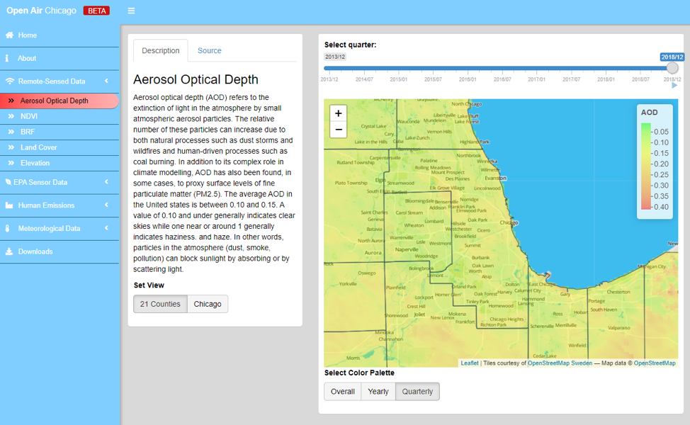
A dashboard tool that combines measurements of key air pollutants with the variables that influence air quality, such as traffic emissions and land cover, is in development (Figure 1).
This tool will help the city of Chicago to analyze its operations, model the impacts of projected environmental changes on the city’s air quality, and facilitate the collaborative development of air pollution interventions by city agencies, researchers, and community stakeholders.
Building Urban Resilience
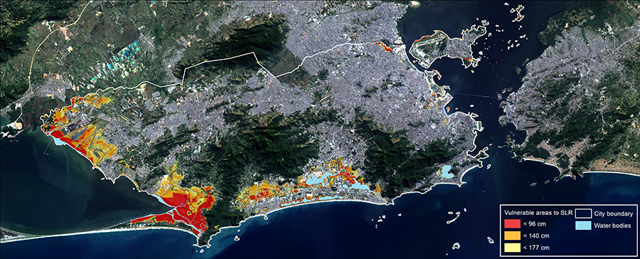
Local data can be combined with climate projections and scientific expertise to enhance cities’ resilience to climate change [Urban Climate Change Research Network, 2018]. Researchers involved in a joint NASA–Rio de Janeiro study identified areas in the city most vulnerable to sea level rise by 2080 (Figure 2) by combining local tide gauge measurements, a lidar survey of city topography, and satellite altimetry data from TOPEX/Poseidon and the Jason missions with Coupled Model Intercomparison Project 5 (CMIP5) climate projections. A map of Rio de Janeiro’s urban heat island, created using Landsat-based land surface temperature data, similarly informed the city’s climate adaptation plans for heat mitigation.
In Chicago, city officials are working with NASA scientists to better understand the temporal and spatial evolution of the city’s urban heat island. As a result of a 2016 workshop, Chicago’s Department of Planning and Development developed a pilot program to use NASA Earth observations in its climate adaptation planning, drawing on input from Microsoft and NASA.
The program will identify the hottest areas in Chicago for further analysis, test the effects of the city’s heat mitigation policy interventions, and create a baseline for future urban planning. One pilot project in this program leverages NASA remote sensing data sets to generate heat maps for cities, whereas another project studies historical data to determine how changes in surface temperatures were related to urban planning policies.
Synergy Between Cities and Product Developers
Strategic project selection in Chicago and Rio de Janeiro has generated beneficial scientific collaborations. The selected projects are advancing scientific understanding, particularly with respect to testing new data products and validating satellite data sets, and they are meeting the needs of the city governments.
For example, testing the GEOS–Chemical Forecast model has provided mutual benefits to both Rio de Janeiro and the NASA model development team. The Rio de Janeiro team provided multiyear air quality station data through an online platform. Comparisons between the air quality forecast model and measurements taken in Rio de Janeiro revealed discrepancies, and efforts to resolve these discrepancies have led to model improvements such as refining the model’s local emissions inventories. Scientists from Rio de Janeiro’s city government offered to test a proposed downscaled version of the forecast model, so they were given early access to a tool that incorporates Rio de Janeiro’s complex topography. This customized tool could be used in the future to warn residents when the forecast calls for potentially hazardous air quality.
Lessons Learned in Rio de Janeiro and Chicago
Scientific collaborations with these two cities benefitted from the cities’ investments of time and resources in joint projects.
Earth observations are enhancing Rio de Janeiro’s and Chicago’s environmental monitoring and long-term planning capabilities through pioneering applications of remote sensing and model-based products at the urban scale. As described above, Earth observations are particularly valuable in cases where in situ observations are nonexistent or limited. And where in situ observations are available, Earth observations are useful in validating remote sensing products and predictive models. Combining in situ observations and local context with satellite observations leads to powerful products that provide cities with localized, actionable information.
Scientific collaborations with these two cities benefitted from the cities’ investments of time and resources in joint projects. Strong relationships between researchers and city officials resulted from years of sustained, regular communication. The collaborations also benefitted from open data sharing practices—the cities published local data online, and NASA made test versions of new products available to city partners—and from the cities’ centralized government structures, which allowed multiple city offices to work toward common goals.
In Rio de Janeiro and Chicago, the cities’ high degree of technical capacity has helped the process of integrating Earth observation products into operations. Conversely, many cities’ lack of technical capacity is a barrier to the adoption of Earth observation products. Small cities and cities in developing countries may lack the workforce capacity or data infrastructure to store, process, and use Earth observation-based products [Kansakar and Hossain, 2016]. Making Earth observation data sets and model outputs easier to download and analyze would greatly facilitate and likely expand their adoption by city governments.
Acknowledgments
The authors thank NASA’s Earth Science Division for supporting collaborative work with Rio de Janeiro and Chicago. The Open Air Chicago project by the Chicago Department of Public Health and the Center for Spatial Data Science at the University of Chicago acknowledges funding from the Bloomberg Philanthropies Partnership for Healthy Cities, with Vital Strategies as an implementing partner, as well as the technical contributions of J. Koschinsky, I. Kamber, J. Wang, A. Ladoy, Y. H. Park, Y. X. Tan, T. Stephens, A. Laha, and G. Morrison. The authors thank N. Pahlevan and C. Keller for providing descriptions of the Landsat-Sentinel water quality anomaly and GEOS-Chemical Forecast products, as well as their collaborative research with the city of Rio de Janeiro. D. Bader, C. Rosenzweig, T. McPhearson, M. Kolak, R. Pandya, and E. Glenn contributed to this article.
References
Bai, X., et al. (2018), Six research priorities for cities and climate change, Nature, 555, 23–25, https://doi.org/10.1038/d41586-018-02409-z.
Creutzig, F., et al. (2019), Upscaling urban data science for global climate solutions, Global Sustain., 2, e2, https://doi.org/10.1017/sus.2018.16.
Famiglietti, J. S., et al. (2015), Satellites provide the big picture, Science, 349(6249), 684–685, https://doi.org/10.1126/science.aac9238.
Ilieva, R. T., and T. McPhearson (2018), Social-media data for urban sustainability, Nat. Sustain., 1, 553–565, https://doi.org/10.1038/s41893-018-0153-6.
Kansakar, P., and F. Hossain (2016), A review of applications of satellite Earth observation data for global societal benefit and stewardship of planet Earth, Space Policy, 36, 46–54, https://doi.org/10.1016/j.spacepol.2016.05.005.
Kirschbaum, D., and T. Stanley (2018), Satellite‐based assessment of rainfall‐triggered landslide hazard for situational awareness, Earth’s Future, 6, 505–523, https://doi.org/10.1002/2017EF000715.
Miller, R. B., and C. Small (2003), Cities from space: Potential applications of remote sensing in urban environmental research and policy, Environ. Sci. Policy, 6, 129–137, https://doi.org/10.1016/S1462-9011(03)00002-9.
Pahlevan, N., et al. (2019), Sentinel-2/Landsat-8 product consistency and implications for monitoring aquatic systems, Remote Sens. Environ., 220, 19–29, https://doi.org/10.1016/j.rse.2018.10.027.
Rosenzweig, C., et al. (2018), Climate change and cities: Second assessment report of the Urban Climate Change Research Network, in Climate Change and Cities: Second Assessment Report of the Urban Climate Change Research Network, edited by C. Rosenzweig et al., pp. xvii–xlii, Cambridge Univ. Press, Cambridge, U.K., https://doi.org/10.1017/9781316563878.007.
United Nations (2019), World Urbanization Prospects 2018: Highlights, New York, population.un.org/wup/Publications/Files/WUP2018-Highlights.pdf.
Urban Climate Change Research Network (2018), The future we don’t want: How climate change could impact the world’s greatest cities, technical report, New York, c40-production-images.s3.amazonaws.com/other_uploads/images/1789_Future_We_Don’t_Want_Report_1.4_hi-res_120618.original.pdf.
Author Information
Margaret M. Hurwitz ([email protected]), NASA Goddard Space Flight Center, Greenbelt, Md.; also at Science Systems and Applications, Lanham, Md.; now at National Weather Service, National Oceanic and Atmospheric Administration, Silver Spring, Md.; Christian Braneon, NASA Goddard Institute for Space Studies, New York, N.Y.; also at SciSpace, Bethesda, Md.; Dalia B. Kirschbaum, NASA Goddard Space Flight Center, Greenbelt, Md.; Felipe Mandarino, Instituto Pereira Passos, Rio de Janeiro City Government, Rio de Janeiro, Brazil; and Raed Mansour, Chicago Department of Public Health, Chicago, Ill.
Citation:
Hurwitz, M. M.,Braneon, C.,Kirschbaum, D. B.,Mandarino, F., and Mansour, R. (2020), Earth observations informing cities’ operations and planning, Eos, 101, https://doi.org/10.1029/2020EO146808. Published on 16 July 2020.
Text © 2020. The authors. CC BY-NC-ND 3.0
Except where otherwise noted, images are subject to copyright. Any reuse without express permission from the copyright owner is prohibited.