Reconstructing the history of Earth’s climate is easier when the story is one long, detailed narrative rather than scattered fragments. Unfortunately, long, continuous, high-resolution terrestrial records of past climate are scarce, with the exception of polar region ice cores and mineral deposits in tropical caves (speleothem records).
The midlatitudes also offer detailed histories that can span the gap in records of past climate between the higher and lower latitudes. Many studies of deep, stable maar lakes—water-filled explosion craters from past volcanic eruptions—in the midlatitudes have demonstrated that these lakes provide exceptionally detailed and continuous records spanning back as far as the past few 100,000 years.
The maar lake sediment records in New Zealand’s Auckland Volcanic Field (AVF) extend back about 250,000 years with variable resolution. These records allow us to construct detailed histories of subtle changes in the nature and timing of AVF volcanism, geomagnetic field intensity, and past climate that will eventually enable us to examine the nature of intrahemispheric and interhemispheric climate linkages in the context of the Southern Hemisphere midlatitudes.
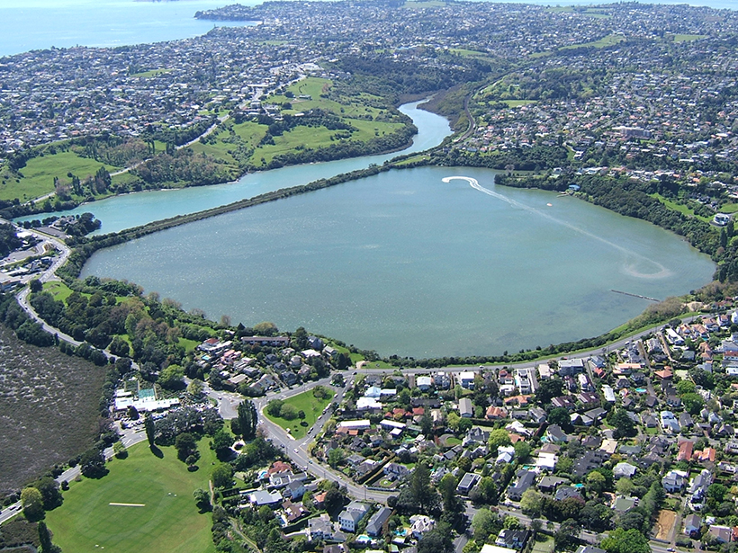
Here we describe the extraction of the most complete record of sedimentation in any Auckland maar lake, the Orakei maar (Figures 1a and 1b). The cores, obtained in 2016, give us the opportunity to produce the most detailed record yet of regional volcanic hazards and drivers of past climate changes spanning most of the last glacial cycle (between about 120,000 and 12,000 years ago) from midlatitude New Zealand.
Past Studies on AVF Maar Lakes
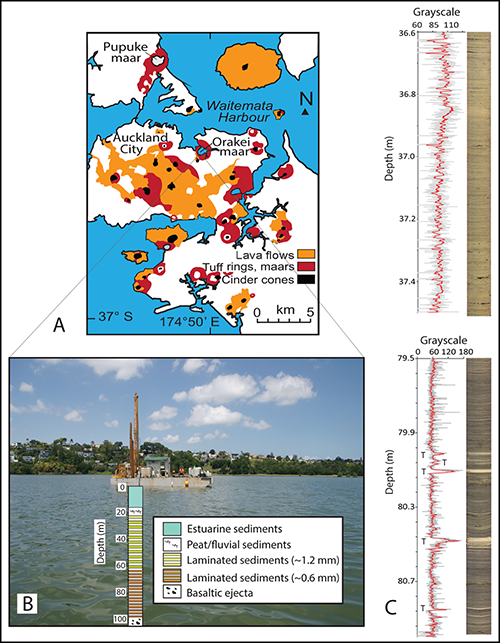
Auckland, New Zealand’s largest and most densely populated center, is home to a dense cluster of about 50 basaltic volcanoes (Figure 1a). The AVF includes lava flows and cinder (scoria) cones, but it also features 13 maars, most of which were lakes and swamps that have since been filled with sediment.
Only one of these maar craters contains a modern deep lake—Lake Pupuke—where continuous lake sediment accumulation has occurred since its formation (Figure 1a). Core samples from this lake have provided geomagnetic, volcanic, and past climate records that serve as the basis for much of the current knowledge of this region.
Geologists have taken core samples from several of the AVF maar lake systems to assess volcanic hazards and study paleoclimate [e.g., Molloy et al., 2009; Augustinus et al., 2011]. However, most work to date has focused on lakes in which slow sedimentation rates create thin layers over the course of many years, making it difficult to narrow down the time frame of any given event from these records.
Also, the sections of these records that we have examined so far go back no more than about 46,000 years. Thus, the Orakei maar represents a unique chance to more than double this time slice.
Why Drill at Orakei Maar?
Identifying long-distance climate connections between our maar lake sediment sequences, the polar regions, and the tropics will enhance our ability to identify climate leads and lags.
We intend to develop high-resolution paleoclimate records from Orakei and other Auckland maars that can be correlated with polar ice core and southeast Asian speleothem isotopic records of paleoclimate from the last glacial cycle. Identifying long-distance climate connections between our Auckland maar lake sediment sequences, the polar regions, and the tropics would enhance our ability to identify climate leads and lags, as well as latitudinal changes in the nature of the signals and their drivers.
What Time Slice Does the Orakei Maar Represent? Evidence from Earth’s Magnetic Field
Previous work on Lake Pupuke cores identified relative geomagnetic intensity changes associated with the Laschamp geomagnetic excursion, about 41,000 years ago. This short-lived decrease in the Earth’s magnetic field intensity was accompanied by a shift in the orientation of the Earth’s magnetic poles. Because the paleomagnetic directional data from Lake Pupuke are not reliable enough to link them directly to the Laschamp geomagnetic excursion, geomagnetic field intensity records and isotopic concentration data serve as proxies to establish this linkage indirectly [Nilsson et al., 2011].
The weakening of the magnetic field during the excursion and the transition periods before and after reduced shielding against galactic cosmic rays, allowing higher than normal production of beryllium-10 (10Be) in the atmosphere. The resulting 10Be nuclides attached to aerosols and rained out from the atmosphere, depositing on the Earth’s surface and accumulating in Lake Pupuke sediments.
We compared 10Be concentration trends in the Lake Pupuke cores with 10Be concentration trends during the Laschamp excursion recorded in Greenland ice cores. This comparison enabled us to directly correlate the records of past climate between these northern polar and southern midlatitude cores [Nilsson et al., 2011].
We intend to extend this approach to the Orakei record back through the entire last glacial cycle so that we can identify precise linkages to the global climate system.
A Chance to Examine Volcanic Ashfalls, Past and Future
Previous work shows that the Orakei maar contains well-laminated lake sediment and the highest sedimentation rates of any of the Auckland maar lakes cored to date [e.g., Molloy et al., 2009]. Rapid deposition ensures that each sediment layer represents a narrower time frame than is available from layers deposited more slowly. This record includes far-traveled ash that originated in the various volcanic centers in the Taupo Volcanic Zone of the central North Island, as well as the local AVF volcanoes [Molloy et al., 2009].
In addition to the visible ash layers, there are plentiful microscopic ash layers (cryptotephra) that significantly increase both the number of identified ashfall events and their frequency. This approach is changing scientific assessments of the volcanic hazards and risks that the Auckland region faces [Shane et al., 2013; Zawalna-Geer et al., 2016].
The cryptotephra work undertaken thus far has focused on Holocene sediment records (about 9000 years ago to the present) from Pupuke maar lake. Orakei maar’s potential to extend the tephra record through the entire last glacial cycle, in combination with development of a robust chronology, will further refine our understanding of the present-day volcanic and ashfall hazards. This extension will also provide new information on the poorly known earlier stages of the evolution of the AVF as well as the tephra sourced from Taupo Volcanic Zone volcanic centers.
Collecting the Orakei Maar Core
Orakei maar is a nearly symmetrical explosion crater, about 1 kilometer wide and close to modern sea level. This crater is phreatomagmatic—the explosion that created it contained gases and steam. In February 2016 a consortium of geologists and paleoclimatologists from the University of Auckland and other New Zealand, German, and U.S. universities began drilling to sample the Orakei maar sediment record.
We used a drilling rig mounted on a floating barge in the middle of the Orakei basin (Figure 1b) to recover about 19 meters of Holocene estuary muds that overlie about 7 meters of peat and river sediments. Below these sediments, a suite of laminated lake sediments extends downward from about 26 to 99.5 meters (Figure 1b). We were able to produce close to 100% recovery because we drilled two overlapping cores that are being combined with a shorter and incomplete record obtained from the basin previously [Molloy et al., 2009].
Our measurements suggest that the paleolake sequence began at least about 120,000 years ago.
We extended the sedimentation rate measurements between known age marker tephra from about 60- to 80-meter depth to the base of the maar lake sequence. Our measurements suggest that the paleolake sequence began at least about 120,000 years ago (sediment compaction compresses the lower part of the record, so older layers are thinner). The mean thickness of the lamina in this part of the paleolake sequence averages about 1.2 millimeters. Within these lamina, volcanic ash sourced from a range of eruptions from the AVF and volcanic centers associated with the Taupo Volcanic Zone are well preserved (Figure 1c) [see also Molloy et al., 2009].
A significant change in the character of the sediments occurs at about 60-meter depth—from this level down to about 99.5 meters, the lamina become darker and thinner, and the average thickness is about 0.6 millimeter. Below this depth, angular and poorly sorted sediments dominated by porous volcanic scoria and fragments of locally sourced rock (country rock clasts) probably represent the material that erupted during the birth of the maar (Figure 1b). Drilling stopped at 105-meter depth in the basaltic ejecta because the laminated lake muds were the primary target of this study.
Analyzing the Cores
An expanded team is now working to analyze the core samples from the Orakei maar using various paleoclimate proxies and dating methods. We will combine high-resolution geochemical scans (down to 0.1-millimeter scale) with X-ray density and magnetic susceptibility scans of the Orakei core to enable us to match the overlapping core sections with confidence, as well as to construct a robust composite stratigraphy. We will also use these scans to help identify events in the sequence (e.g., turbidites) and changes in character of the lamina that may have paleoclimatic significance.
We will be using a suite of dating tools to produce a reliable chronology that extends beyond the limit of carbon (14C) dating methods. These tools include luminescence dating, paleomagnetism, and meteoric 10Be flux. In addition, we will attempt to define the ages of zircon-containing tephra that we encounter using an ion probe to measure uranium and its radioactive decay products ((U-Th)/He dating).
Subsequently, we will conduct high-resolution paleoclimate analyses using a range of proxies: climate-correlated measurements that provide climate information indirectly. Pollen, diatoms, and chironomids provide information on the ancient environments and temperature regimes in which they lived. Lipid biomarkers provide additional information on paleotemperature. We will also analyze bulk and compound-specific organic matter isotopes to learn more about rainfall patterns (paleoprecipitation) and the distribution of nutrients (paleoproductivity).
Using this approach, we eventually hope to have the first reliably dated and high-resolution paleoclimate record spanning the last glacial cycle from New Zealand and probably the best available from the Southern Hemisphere midlatitudes.
Acknowledgments
The drilling investigation team included Paul Augustinus, Jan Lindsay, Phil Shane (University of Auckland), Jenni Hopkins and Graham Leonard (GNS Science), Valerie van den Bos (Victoria University of Wellington), Tim Shanahan and Natalia Piatrunia (University of Texas at Austin), and Frank Sirocko (University of Mainz). A larger team is now working on the various paleoclimate proxies and dating methods being used on the Orakei maar sediments. The project was funded by New Zealand’s Earthquake Commission, the Auckland Council, and a grant from the Royal Society of New Zealand Marsden Fund.
References
Augustinus, P. C., D. D’Costa, Y.-B. Deng, J. Hagg, and P. A. Shane (2011), A multi-proxy record of changing environments from ca. 30,000 to 9,000 cal yr BP: Onepoto maar paleolake, Auckland, New Zealand, J. Quat. Sci., 26, 389–401, doi:10.1002/jqs.1463.
Molloy, C., P. Shane, and P. Augustinus (2009), Eruption recurrence rates in a basaltic volcanic field based on tephra layers in maar sediments: Implications for hazards in the Auckland volcanic field, Geol. Soc. Am. Bull., 121, 1666–1677, doi:10.1130/B26447.1.
Nilsson, A., R. Muscheler, I. Snowball, A. Aldahan, G. Possnert, P. Augustinus, D. Atkin, and T. Stephens (2011), Multi-proxy identification of the Laschamp geomagnetic field excursion in Lake Pupuke, New Zealand, Earth Planet. Sci. Lett., 311, 155–164, doi:10.1016/j.epsl.2011.08.050.
Shane, P., M. Gehrels, A. Zawalna-Geer, P. Augustinus, J. Lindsay, and I. Chaillou (2013), Longevity of a small shield volcano revealed by crypto-tephra studies (Rangitoto volcano, New Zealand): Change in eruptive behavior of a basaltic field, J. Volcanol. Geotherm. Res., 257, 174–183, doi:10.1016/j.jvolgeores.2013.03.026.
Zawalna-Geer, A., J. M. Lindsay, S. Davies, P. Augustinus, and S. Davies (2016), Extracting a primary Holocene crytotephra record from Pupuke maar sediments, Auckland, New Zealand, J. Quat. Sci., 31(5), 442–457, doi:10.1002/jqs.2866.
Author Information
Paul C. Augustinus, School of Environment, University of Auckland, Auckland, New Zealand; email: [email protected]
Correction, 26 September 2016: The length of the maar lake sediment records in New Zealand’s Auckland Volcanic Field has been corrected.
Citation:
Augustinus, P. C. (2016), Probing the history of New Zealand’s Orakei maar, Eos, 97, https://doi.org/10.1029/2016EO059227. Published on 20 September 2016.
Text © 2016. The authors. CC BY-NC-ND 3.0
Except where otherwise noted, images are subject to copyright. Any reuse without express permission from the copyright owner is prohibited.