
At mid-ocean ridges, such as the one that runs along the full length of and 3 kilometers below the surface of the Atlantic Ocean, new oceanic plate material forms as the plates on either side are pulled apart and hot underlying mantle rises to fill the space. Material spreading from the ridge cools into an increasingly thick plate, topped by a crust of solidified mantle melts. Below the Pacific, spreading can reach speeds of over 15 centimeters per year. However, the plates pull apart slower below the Atlantic, at rates of only a few centimeters per year. This rate leads to cooler plates with less melting and more fracturing, which provides additional pathways for water to enter the plate. Upon reaching a subduction zone, where plate convergence forces one plate to dive below the other, the sinking plate will heat up and get squeezed, resulting in the release of some or all of its water into the deeper Earth. Scientists have studied this subduction-water cycle in the fast spreading Pacific. Now our Volatile Recycling in the Lesser Antilles (VoiLA) project targets one of only two zones that currently subduct lithosphere formed by slow spreading in the Atlantic.
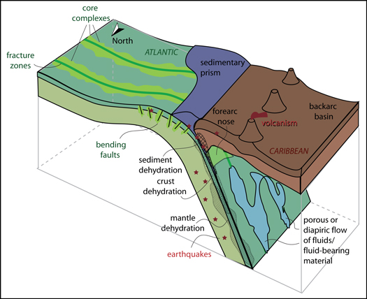
Earth’s deep cycle of volatiles, of which water (H2O), carbon dioxide (CO2), and sulfur are the most important constituents, is key to understanding the origins of life, the formation of continents, the generation of metalliferous resources, and the most violent geohazards. Subducting plates are important in this cycle, carrying volatiles from Earth’s surface into the mantle as fluids trapped in pores found in sediments and crust, as well as in volatile-bearing minerals in the deeper plate. As plates sink and heat up, released fluids can trigger seismicity and induce melting within the subducted plate and in the overlying mantle wedge. This type of melting selectively concentrates volatiles and transports them into the overlying plate. If an eruption occurs, the cycle then returns the volatiles into the oceans and atmosphere (Figure 1).
Exactly where and how volatiles are released and how they modify the host rock remain an area of intense research. Much of a plate’s hydration is acquired at mid-ocean ridges. In the slowly spreading Atlantic lithosphere, the plate is hydrated more pervasively and heterogeneously than the fast spreading Pacific lithosphere (Figure 2). Therefore, expressions of volatiles are likely to be more pronounced during the subduction of lithosphere that is formed by slow spreading. Today, subduction is predominantly consuming lithosphere formed at relatively fast spreading ridges. However, in the past, when the Tethys Ocean was being subducted, slow spreading was common.
We investigate how the volatile cycle for the little-studied subduction in the Atlantic differs from that in subduction zones in the Pacific (which has been extensively studied by efforts like Geodynamic Processes at Rifting and Subducting Margins (GeoPRISMS)). We do so by targeting the Lesser Antilles, located in the Caribbean Sea.

Hydration of Slow Versus Fast Spreading Oceanic Lithosphere
Mid-ocean ridge research has revealed that the character of oceanic lithosphere changes strongly with spreading rate (Figure 2). Classical magmatic accretion dominates at fast spreading ridges. In contrast, at slow spreading ridges much of the extension is taken up by faulting. The nature of this faulting varies along strike depending on the melt supply. When supply is low, large-scale detachment faults form that bring mantle rocks up to the seabed. Both processes tend to occur at seafloor-spreading segment ends and substantially increase the hydration potential of the oceanic lithosphere, as hydrous, or serpentinized, mantle can hold 2–3 times as much water as the equivalent volume of basaltic crust. Additional hydration occurs along transforms, where the cool thermal state of slowly spread lithosphere provides conditions for deep hydration, augmenting along-strike variations in its volatile budget.
The Antilles Subduction End Member
Our VoiLA experiment targets the Antilles subduction zone, which consumes slowly spread lithosphere with a number of very pronounced fracture zones.
Understanding volatile cycling in subduction zones requires scientists to synthesize observations from different settings with contrasting incoming plate age, spreading rate, degree of sedimentation, fracture zone density, and plate bending. Of the few zones presently subducting slowly spread lithosphere, none has been studied with a comprehensive multidisciplinary effort.
Our VoiLA experiment, funded by the U.K. Natural Environment Research Council, targets the Antilles subduction zone, which consumes slowly spread lithosphere with a number of very pronounced fracture zones (Figure 3). It also subducts old plate at an unusually slow rate. There are appreciable differences in sediment thickness and composition along the arc, owing to the large supply of terrestrial sediment in the south from the Orinoco River. Plate coupling and earthquake productivity are strongest in the north, often attributed to variable input of fluids and/or sediments. The volcanic islands vary significantly in size, evidence of variable long-term magmatic productivity, possibly linked to variable slab dehydration. A few previous studies [Schlaphorst et al., 2016; Paulatto et al., 2017] found along-arc variations in seismicity rates and seismic velocity structure in the slab and overlying mantle wedge that may correlate with fracture zone distribution.

The VoiLA project
Our project (October 2015 to March 2021) comprises two marine scientific cruises on the RRS James Cook (JC133 and JC149), temporary seismic deployments on the islands, geological fieldwork, geochemical and petrological analyses, and numerical modeling (Figure 3).
Between March 2016 and May 2017, we deployed 34 broadband ocean bottom seismometers (BBOBS) on the Lesser Antilles arc, fore arc, and back arc: 24 Trillium Compact from German Deutscher Geräte-Pool für amphibische Seismologie (DEPAS) and 10 Trillium 240 from Scripps Trillium 240. Thirty-two of these instruments successfully recorded natural earthquake data, as well as the air gun shots from two along-arc lines (Figure 3). All eight stations deployed on the southern islands, from Saint Lucia to Grenada, recorded earthquakes between January 2017 and January 2018, and seven registered the arc–back-arc shots. Nine of 10 stations deployed on Guadeloupe-Martinique from October 2016 until March 2017 recorded earthquake data for at least part of this time. The BBOBS data quality is excellent, with low noise levels comparable to many land stations, and the island stations exhibit noise levels only slightly higher than permanent island stations.
During JC149, we shot three active-source wide-angle refraction lines and supplementary multichannel reflection lines on the incoming plate to survey structures across the fracture zones and to determine where the plate bends into the trench. We successfully recorded data with 133 instruments from the German DEPAS and U.K. Ocean-Bottom Instrumentation Facility. Here too, data quality is excellent, and early travel time models show a strong contrast in seismic velocity structure across the medium-offset fracture zones.
Initial results from VoiLA surface wave imaging and Wadati-Benioff seismicity relocation indicate pronounced and variable fluid signatures along the arc.
In addition, we collected gravity, magnetic, and bathymetry data throughout the two cruises and dredged a number of samples from one of the bathymetric ridges. We surveyed underwater volcano Kick’em Jenny using swath bathymetry on both cruises, bracketing its most recent eruption [Allen et al., 2018]. We conducted geological fieldwork on Saint Martin, Saint Kitts, Nevis, Guadeloupe, and La Désirade to collect mafic volcanic material to target melt inclusions and to complement the existing, extensive University of Bristol and Durham University collections of volcanic and xenolith samples along the arc. Initial results from VoiLA surface wave imaging and Wadati-Benioff seismicity relocation indicate pronounced and variable fluid signatures along the arc.
Future Work
In ongoing work, we are imaging the structure of the incoming plate to test the extent of hydration and serpentinization near fracture zones and during plate bending. We will improve the characterization of seismicity in and between this and the upper plate to aid insight into the region’s poorly characterized seismic hazard. A combination of active- and passive-source seismic data will provide new constraints on the highly variable crustal structure along the arc and the enigmatic back-arc Grenada basin. We plan to use arc structure combined with petrologic and geochemical data to investigate the source and depth of melt generation, its transport, and its evolution. Body wave, surface wave, and attenuation tomography and imaging of seismic anisotropy in the mantle wedge, together with geochemical analyses and thermal and flow models, will help constrain mantle flow and fluid pathways. We are analyzing volcanic samples for trace elements, including ore metals, boron isotopes, and volatile contents, with a particular focus on how along-arc variations may be coupled to the structure and hydration state of the incoming plate.
Our passive seismic data set should be ready to be archived and made generally available through the Incorporated Research Institutions for Seismology by June 2021. Underway geophysical data will be accessible via the British Oceanographic Data Centre. Geochemical data will be added to the Geochemistry of Rocks of the Oceans and Continents (GeoROC) database. Our website will provide further updates and outcomes.
Acknowledgments
Funding was provided by Natural Environment Research Council grant NE/KO10743/1. In addition to the authors, our team comprises Richard Davy, Ben Maunder, and Rob Allen (Imperial College London, United Kingdom); Stephen Hicks and Ben Chichester (University of Southampton, United Kingdom); Lidong Bie (University of Liverpool, United Kingdom); David Schlaphorst, Lena Melekhova, and George Cooper (University of Bristol, United Kingdom); and partners Joan Latchman, Richard Robertson, and Lloyd Lynch at the Seismological Research Centre, University of West Indies, Trinidad; Frank Krüger and Henning Lilienkamp at the University of Potsdam, Germany; and Steve Tait at Institut de Physique du Globe de Paris, France. We thank two reviewers. This article is in memory of Jon Davidson. Without his drive we would not have started the project.
References
Allen, R., et al. (2018), 30 years in the life of an active submarine volcano: A time-lapse bathymetry study of the Kick-’em-Jenny volcano, Lesser Antilles, Geochem. Geophys. Geosyst., 19, 715–731, https://doi.org/10.1002/2017GC007270.
Paulatto, M., et al. (2017), Dehydration of subducting slow-spread oceanic lithosphere in the Lesser Antilles, Nat. Commun., 8, 15980, https://doi.org/10.1038/ncomms15980.
Schlaphorst, D., et al. (2016), Water, oceanic fracture zones and the lubrication of subducting plate boundaries-insights from seismicity, Geophys. J. Int., 204, 1,405–1,420, https://doi.org/10.1093/gji/ggv509.
Author Information
Saskia Goes ([email protected]) and Jenny Collier, Imperial College London, U.K.; Jon Blundy, University of Bristol, U.K.; Jon Davidson, Durham University, U.K.; Nick Harmon and Tim Henstock, University of Southampton, U.K.; J. Michael Kendall, University of Bristol, U.K.; Colin Macpherson, Durham University, U.K.; Andreas Rietbrock, University of Liverpool, U.K.; also at Karlsruhe Institute of Technology, Germany; Kate Rychert, University of Southampton, U.K.; Julie Prytulak, Imperial College London, U.K.; also at Durham University, U.K.; Jeroen van Hunen, Durham University, U.K.; Jamie J. Wilkinson, Imperial College London, U.K.; also at Natural History Museum, London, U.K.; and Marjorie Wilson, University of Leeds, U.K.
Citation:
Goes, S.,Collier, J.,Blundy, J.,Davidson, J.,Harmon, N.,Henstock, T.,Kendall, J. M.,Macpherson, C.,Rietbrock, A.,Rychert, K.,Prytulak, J.,van Hunen, J.,Wilkinson, J. J., and Wilson, M. (2019), Project VoiLA: Volatile Recycling in the Lesser Antilles, Eos, 100, https://doi.org/10.1029/2019EO117309. Published on 14 March 2019.
Text © 2019. The authors. CC BY 3.0
Except where otherwise noted, images are subject to copyright. Any reuse without express permission from the copyright owner is prohibited.