In 2008, during the International Polar Year campaign, a team of researchers and engineers traveled to a remote location high on the East Antarctic Plateau (EAP). There, they installed PG1, the first station in an autonomous six-station instrument array designed to monitor geospace, the near-Earth space environment.
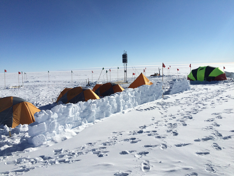
Eight years later—despite frigid weather, the thin atmosphere at a pressure altitude of 3000–4000 meters above sea level, and various logistical challenges inherent in positioning stations across the broad but desolate EAP—the array is now complete. The last station, PG5, was installed in January 2016.
The full instrument array is now returning data on high-latitude electrical current systems, plasma waves, and irregularities in the ionosphere.
The full array (Figure 1, red dots) currently spans roughly 10° of latitude, roughly 1000 kilometers, along the 40° longitude geomagnetic meridian. It is now returning data on high-latitude electrical current systems, plasma waves, and irregularities in the ionosphere.
Observations from this array, when combined with those from an array in Greenland, enable researchers to monitor geospace above both hemispheres simultaneously in more detail than ever before.
Dynamic electrical currents flow between different regions of geospace, heating Earth’s upper atmosphere. These currents can affect human technology in undesirable ways: enhancing satellite drag, distorting radio communication, and inducing unwanted electrical currents in power grids. Understanding and predicting how these currents couple different parts of geospace is a major goal of the space plasma physics research community.
High-latitude current systems are particularly important, as they couple the solar wind to the geospace system. Ground-based instrument arrays can remotely sense such currents with high spatial and temporal resolution, exploring their properties on a range of scales and providing context for sparse satellite measurements.
Why Antarctica?
We need measurements in both hemispheres to characterize the geospace environment and understand what causes asymmetries between the north and south.
Because most ground observations come from the Northern Hemisphere, it is common to assume that such observations represent the overall geospace environment. However, the increasing availability of measurements in Antarctica show that this assumption is not always correct. In fact, this assumption occasionally fails spectacularly when brilliant auroras are seen in the Southern Hemisphere but not the Northern Hemisphere or vice versa. To get the complete picture, we need measurements in both hemispheres in order to characterize the geospace environment and understand what causes asymmetries between the north and south.
Earth’s internally generated magnetic field organizes the high-latitude electrical currents that flow along the magnetic field. By tracing the field from preexisting Northern Hemisphere stations to the Southern Hemisphere, we can identify ideal “magnetically conjugate” locations, that is, pairs of locations that mark the beginning and end of a magnetic field line that enable us to track current systems in each hemisphere simultaneously.
As the solar wind distorts Earth’s magnetic field, these stations will remain well situated for interhemispheric comparisons of high-latitude current systems under most conditions. A north–south array of magnetically conjugate instruments is a powerful tool for interhemispheric comparisons because it allows researchers to investigate the spatial structure of current systems while constraining how interhemispheric comparisons are affected by latitude-dependent distortions in Earth’s magnetic field.
Specially Designed Instrument Platforms
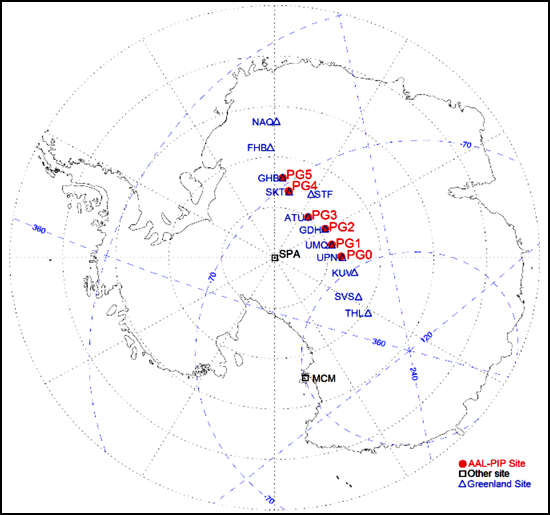
EAP and the west coast of Greenland are two of just a few high-latitude locations on Earth large enough for a conjugate instrument array. Through collaboration between Virginia Polytechnic Institute and State University (Virginia Tech), which operates Antarctic instruments (Figure 1, red dots), and the National Space Institute at the Technical University of Denmark (DTU Space), which operates Greenland’s magnetometers (Figure 1, blue dots), it is now possible to observe large currents, plasma waves, and other phenomena in both hemispheres simultaneously.
However, the harsh EAP environment proved to be a challenging location in which to deploy and maintain instruments, with extreme winds, typical temperatures from −70°C to −14°C, and limited infrastructure. To help overcome this, the University of Michigan and Virginia Tech partnered to develop and deploy autonomous adaptive low-power instrument platforms (AAL-PIP).
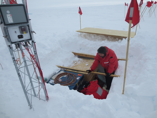
These platforms provide a way of powering and communicating with multiple instruments in the harsh Antarctic environment. Each platform consists of a central pit with a battery box, an electronics box, and a solar panel tower. Wires connect the central pit to four different instruments at varying distances, which can be as far as 50 to 100 meters away.
Developing AAL-PIP platforms leveraged many years of experience with similar instruments in Greenland and Antarctica. These AAL-PIP platforms are designed to be easily and quickly deployed during cold weather conditions, requiring few tools. The solar panel and battery-powered system are programmed for optimal power consumption.
As a result, high-resolution measurements from many instruments, including a fluxgate magnetometer, induction magnetometer, GPS receiver, and high-frequency radio experiment, are taken for most of the year [Clauer et al., 2014]. The AAL-PIP station at PG1, for example, has operated continuously with few problems for 8 years.
A Challenging Deployment
The first and last stations to be deployed, PG1 in 2008 and PG5 in 2016, highlight the challenges of deploying instruments on EAP. PG1 and other locations in the chain are sited at pressure elevations of 3000–4000 meters; high elevations combine with cold, windy conditions to make camping and installation more difficult.
Because the cold weather rapidly discharged power drill and satellite phone batteries required for installation and communication, team members provided their own heat source: They constantly sheltered the batteries under their coats and in their sleeping bags. At the highest elevations, it took a very long time to boil snow to replenish drinking water supplies, and team members experienced shortness of breath while they were working.
All stations in the chain require LC-130 and Twin Otter airplane support to transport cargo, camping equipment, and the team. Flights to PG5 stop at New Zealand, McMurdo Station, the SPA South Pole Station, and a fuel cache before arriving at PG5. Flights from SPA to remote locations on EAP are only available a few weeks each year, and they are often canceled because of bad weather, sometimes stranding team members for weeks at a time. Our team overcame these challenges with considerable support from the U.S. Antarctic Program.

New Perspectives on the Geospace Environment
The spacing and sampling rates of AAL-PIP and DTU Space magnetometers are ideally suited for interhemispheric comparisons of mesoscale current dynamics: fluctuations spanning hundreds to thousands of kilometers occurring over timescales shorter than 10 minutes.
Kim et al. [2013] used this capability to compare the timing and amplitude of magnetic perturbations associated with such currents in each hemisphere. The same group further probed the structure of transient currents, using each array to confirm the presence or absence of uniquely structured vortices associated with localized currents aligned with Earth’s magnetic field [Kim et al., 2015]. A team at Virginia Tech is now comparing AAL-PIP data with numerical simulations and other data sets to explore the sources of these interhemispheric differences.
AAL-PIP data are being used to explore the source of irregularities in the ionosphere that can affect radio communication and the accuracy of GPS signals.
AAL-PIP data are also being used to explore the source of irregularities in the ionosphere—the charged plasma of Earth’s upper atmosphere—that span about 10 kilometers; these phenomena can affect radio communication and the accuracy of GPS signals. Using instruments from this array, Deshpande et al. [2012] first demonstrated the capability of the Connected Autonomous Space Environment Sensor GPS receiver for science-grade measurements, whereas Kim et al. [2014] used fluxgate magnetometers, induction magnetometers, and GPS receivers to show that plasma waves can modulate ionospheric irregularity dynamics.
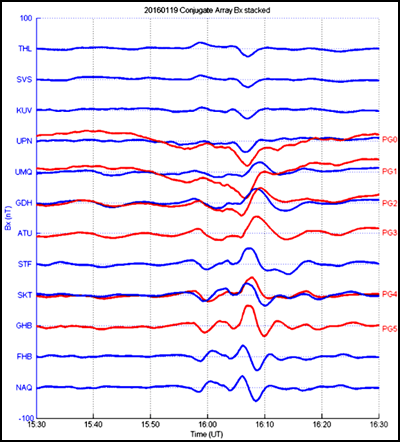
The newly completed array makes it possible to compare magnetic perturbations between hemispheres (Figure 2). Such perturbations are seen at Northern Hemisphere Greenland stations (blue lines) and their Southern Hemisphere AAL-PIP counterparts (red lines) over a large spatial region. As in the transient current events discussed by Kim et al. [2013, 2015], the amplitude and phase of these perturbations varies rapidly with latitude and between hemispheres. Comparisons such as these can reveal how magnetic field topology and charged particle precipitation, both of which vary with hemisphere and latitude, affect the properties of transient currents and other geospace phenomena.
A Powerful Combined Tool
The six closely spaced AAL-PIP stations are a powerful new tool for remote sensing of high-latitude current systems, plasma waves, and ionospheric irregularities on a wide range of temporal and spatial scales, providing a unique Southern Hemisphere perspective. When these observations are combined with satellite measurements and ground-based data from Greenland, they provide a truly global perspective of the geospace environment.
Acknowledgments
This project was supported by the National Science Foundation, which manages the U.S. Antarctic Program. AAL-PIP fluxgate magnetometer data are available via online databases: Magnetosphere-Ionosphere Science Team (MIST), Time History of Events and Macroscale Interactions During Substorms (THEMIS), Coordinated Data Analysis Web (CDAWeb), and SuperMAG. Other data are available by contacting MIST.
References
Clauer, C. R., et al. (2014), An autonomous adaptive low-power instrument platform (AAL-PIP) for remote high-latitude geospace data collection, Geosci. Instrum. Methods Data Syst., 3, 211–227, doi:10.5194/gi-3-211-2014.
Deshpande, K. B., G. S. Bust, C. R. Clauer, H. Kim, J. E. Macon, T. E. Humphreys, J. A. Bhatti, S. B. Musko, G. Crowley, and A. T. Weatherwax (2012), Initial GPS scintillation results from CASES receiver at South Pole, Antarctica, Radio Sci., 47, RS5009, doi:10.1029/2012RS005061.
Kim, H., X. Cai, C. R. Clauer, B. S. R. Kunduri, J. Matzka, C. Stolle, and D. R. Weimer (2013), Geomagnetic response to solar wind dynamic pressure impulse events at high-latitude conjugate points, J. Geophys. Res. Space Phys., 118, 6055–6071, doi:10.1002/jgra.50555.
Kim, H., C. R. Clauer, K. Deshpande, M. R. Lessard, A. T. Weatherwax, G. S. Bust, G. Crowley, and T. E. Humphreys (2014), Ionospheric irregularities during a substorm event: Observations of ULF pulsations and GPS scintillations, J. Atmos. Sol. Terr. Phys., 114, 1–8, doi:10.1016/j.jastp.2014.03.006.
Kim, H., C. R. Clauer, M. J. Engebretson, J. Matzka, D. G. Sibeck, H. J. Singer, C. Stolle, D. R. Weimer, and Z. Xu (2015), Conjugate observations of traveling convection vortices associated with transient events at the magnetopause, J. Geophys. Res. Space Phys., 120, 2015–2035, doi:10.1002/2014JA020743.
Author Information
Michael D. Hartinger, C. Robert Clauer, and Zhonghua Xu, Bradley Department of Electrical and Computer Engineering, Virginia Polytechnic Institute and State University, Blacksburg, Va.; email: [email protected]
Citation:
Hartinger, M. D.,Clauer, R. C., and Xu, Z. (2016), Space weather from a southern point of view, Eos, 97, https://doi.org/10.1029/2016EO061791. Published on 27 October 2016.
Text © 2016. The authors. CC BY-NC-ND 3.0
Except where otherwise noted, images are subject to copyright. Any reuse without express permission from the copyright owner is prohibited.