Cycles of ice sheet growth (glacials) and intervening warmth (interglacials) in Earth’s past—largely triggered by shifts in the amount of solar radiation (insolation) reaching the planet—have been characterized by major changes in global atmospheric carbon dioxide (CO2) levels, sea levels, and temperatures. Around the time of the Last Glacial Maximum 20,000 years ago, for example, average global temperatures were roughly 6°C (11°F) colder, and sea levels were more than 120 meters (400 feet) lower than today, whereas ice covered about a quarter of Earth’s land surface.
Such changes have had profound effects on ecosystems, particularly coastal ecosystems, including coral reefs. And as CO2 levels, temperatures, and sea levels rise rapidly around the world today, modern ecosystems—humans included—will likely continue to experience major impacts as well.
Coral reef systems are highly sensitive to sea level and climate, and fossil reefs preserve reliable records of past variations.
Yet many unknowns remain about the mechanisms that control climate transitions, particularly during past episodes of rapid warming. These unknowns raise critical questions about present and future warming as well: Are predictions of catastrophic sea level rise—up to several meters—resulting from ice sheet collapse valid? Will the behavior and effects of annual to interannual climate phenomena, such as the El Niño–Southern Oscillation and seasonal rainfall, change as the average global climate changes?
Also uncertain is how coral reefs and coasts will respond to associated environmental stresses. Coral reef systems are highly sensitive to sea level and climate, and fossil reefs preserve reliable records of past variations. Yet our understanding of these variations is severely limited because we lack continuous fossil coral records, particularly from periods of abrupt climate instability. Such records are exceptionally rare given the specific conditions required to build and preserve fossil reef sequences over extended periods and the difficulty of sampling them where they do occur.
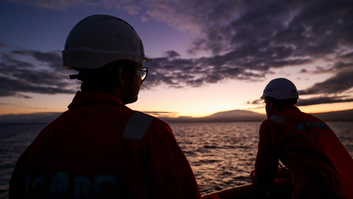
In fall 2023, scientists and crew on the International Ocean Discovery Program’s (IODP) Expedition 389 (X389) employed an advanced, remotely operated seabed drilling system to access the interiors of submerged, or “drowned,” fossil reefs off the island of Hawai‘i for the first time (Figure 1). The reef sequences there contain globally unique records of sea level and climate change—and their impacts on reef ecosystems—over the past 500,000 years [Webster et al., 2025].
Hawai‘i’s Unique Reef Records
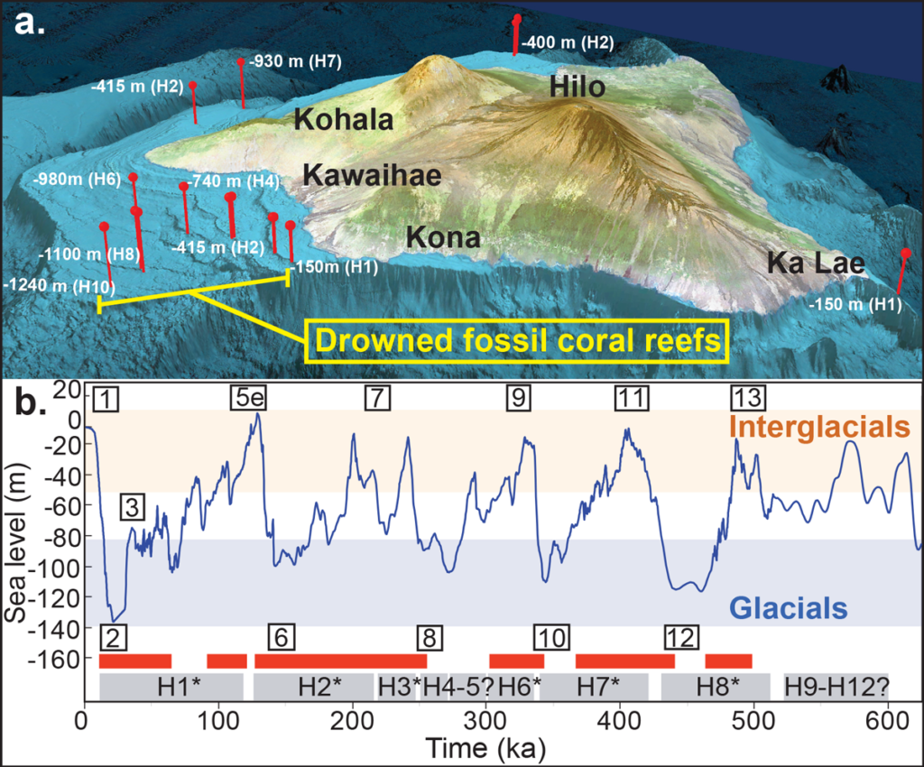
Hawai‘i is geologically special. Located over an active volcanic hot spot, it has been—and continues to be—built up by successive eruptions. As the underlying mantle compensates for the increasing weight of the island, the ocean crust has experienced nearly constant subsidence over the past 500,000 years. This subsidence creates space that accommodates growth and vertical expansions of reefs, which, as they accumulate and fossilize, capture conditions through glacial-interglacial intervals in great detail (Figures 1b and 2). These reefs ring the island, forming a spectacular sequence of increasingly older terraces between 100 and 1,500 meters below present sea level (Figure 1a).
Rapid sea level rises linked to catastrophic ice sheet collapse and abrupt meltwater pulse events during deglaciations cause reef drowning.
The reefs have been the subject of 4 decades of data collection and study involving multiple methods of seafloor imaging (bathymetric, backscatter, and seismic) and sampling (with dredges, submersibles, and remotely operated vehicles), as well as geochronologic methods and numerical modeling [Webster et al., 2009]. These prior data underpin our knowledge of fossil reef development and motivated the scientific rationale and drilling strategy of X389.
As Hawai‘i subsides at a rate of 2.5 millimeters per year, space below the ocean surface is created for reef growth in the near term (Figure 2). But how do large and longer-term sea level changes occurring through glacial-interglacial intervals affect reefs?
Reef growth initiates during sea level highstands and continues during glaciation as sea levels slowly drop. If sea level falls quickly, outpacing the island’s subsidence rate, the living part of the reef dies as it is exposed above the waves. If, on the other hand, sea level rises too quickly and new reef growth—which requires the sunlight available near the ocean surface—fails to keep up, the reef will deepen and ultimately drown.

Rapid sea level rises linked to catastrophic ice sheet collapse and abrupt meltwater pulse events during deglaciations thus cause reef drowning [Sanborn et al., 2017]. Then, during the subsequent warm high sea level stand, a new reef is initiated upslope, and the cycle starts again.
Numerical models of reef growth and demise, forced by changes in sea level, predict that the Hawaiian terraces comprise thicker sequences of fossilized reef—100–150 meters per glacial cycle—compared with those built on stable margins such as the Great Barrier Reef. As such, the Hawaiian expanded sequences hold great promise for providing sea level and climate records of unprecedented resolution and detail.
To sample these Hawaiian reefs across a range of water depths and challenging lithologies (they commonly fragment and break), researchers required a novel drilling system—unavailable to the scientific community until recently—that could penetrate the reef interior rather than just scratch its surface.
The Core of the Matter
The X389 team found the needed technology in Benthic’s fifth-generation portable remotely operated drill (PROD5). This commercial, tethered device can be guided to and secured at seafloor targets as deep as several kilometers, where its automated capabilities allow it to collect long sample cores (up to 73 meters below the seafloor in the case of X389). A major advantage of seafloor drills over ship-based systems is that they’re stationary, which makes it easier to keep constant weight on the drill bit and improves recovery of continuous core segments.
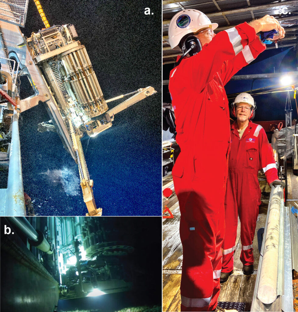
Sailing aboard the MMA Valour, the expedition used PROD5 to obtain reef material from roughly the past 500,000 years to address four major objectives: (1) measuring the extents of past sea level variations, (2) investigating seasonal to millennial climate and oceanic change, (3) assessing coral reef ecosystem responses to abrupt sea level and climate changes, and (4) improving knowledge of the growth and subsidence of Hawai‘i over time.
Over the course of 2 months in fall 2023, we deployed the drill at 16 drowned reef sites offshore Hawai‘i, coring 35 holes at water depths ranging from 132 to 1,242 meters (Figure 1a). A total of 425 meters of core were recovered, comprising both reef (83%) and volcanic (17%) materials. Core recoveries averaged 66%, and numerous intervals of well-preserved reef samples exhibited recoveries greater than 90%, significant achievements compared with recoveries from prior expeditions. For example, core recoveries averaged 27% using a ship-based drilling system during Expedition 325 to the Great Barrier Reef in 2010 [Webster et al., 2011].
The deployments were largely successful, but the expedition was not all smooth sailing.
The deployments were largely successful, but the expedition was not all smooth sailing. Technical issues with the drill, including mechanical breakdowns and difficulties penetrating heterogeneous coral reef material, limited our ability to reach all target depths.
Moreover, the expedition did not adequately engage with community members about the plans and purpose of its research or about concerns it may have posed. This regrettable oversight alienated members of the local and Native Hawaiian communities, some of whom expressed frustration at not being informed or consulted prior to the Valour’s arrival offshore and voiced uncertainties over possible environmental harms.
In addition to damaging the expedition’s relationship with local communities, the lack of timely and vital engagement directly affected the science we could pursue. The concerns raised by community members contributed to the denial of a permit to drill in state waters—a decision received after X389 was already at sea—meaning that we could not sample at some young, science-critical reef sites as originally planned.
Consequently, we pivoted our approach to add more sites in federal waters where we could sample other young reef sequences and to drill transects of shorter, but high-quality, cores to capture small sea level oscillations. Since the research cruise, expedition members have sought to redouble community engagement efforts to redress the offenses and concerns caused by the expedition.
Ancient Anatomy Lessons
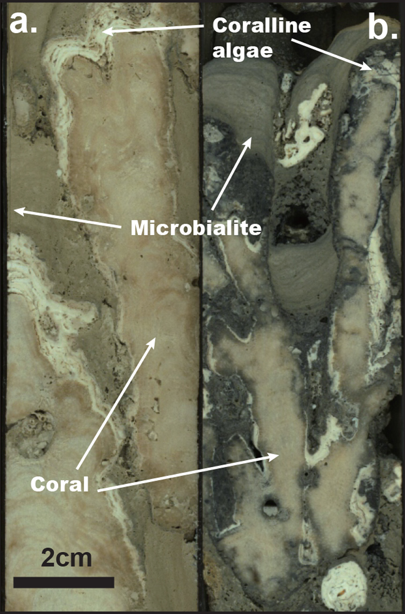
Analysis of the hundreds of meters of core collected during X389 will reveal, for the first time, the complex internal anatomy and composition of Hawai‘i’s extensive reef packages through the past half million years. Preliminary visual observations have already offered glimpses of exquisite new details, including drowning reef sequences formed during the terminations of glacial periods [Webster et al., 2025]. The building blocks of these drowning reefs include branching, columnar, and massive shallow corals; several types of microbialite; thick crustose coralline algae (Figure 3); lithified and unlithified sediments; and a diversity of volcanic flows and associated sediments.
Observations so far also suggest that our sampling captured distinct shallow, intermediate, and deep reef communities and depositional settings, as well as the first evidence of major lithologic boundaries indicating repeated reef initiation and demise, as predicted by models and previous seafloor observations [Webster et al., 2009] (Figure 2). Furthermore, substantial differences in sedimentary contributions to the reefs between the dry and wet sides of Hawai‘i highlight that variations in precipitation, sediments, and nutrient input might influence reef evolution (Figure 3).
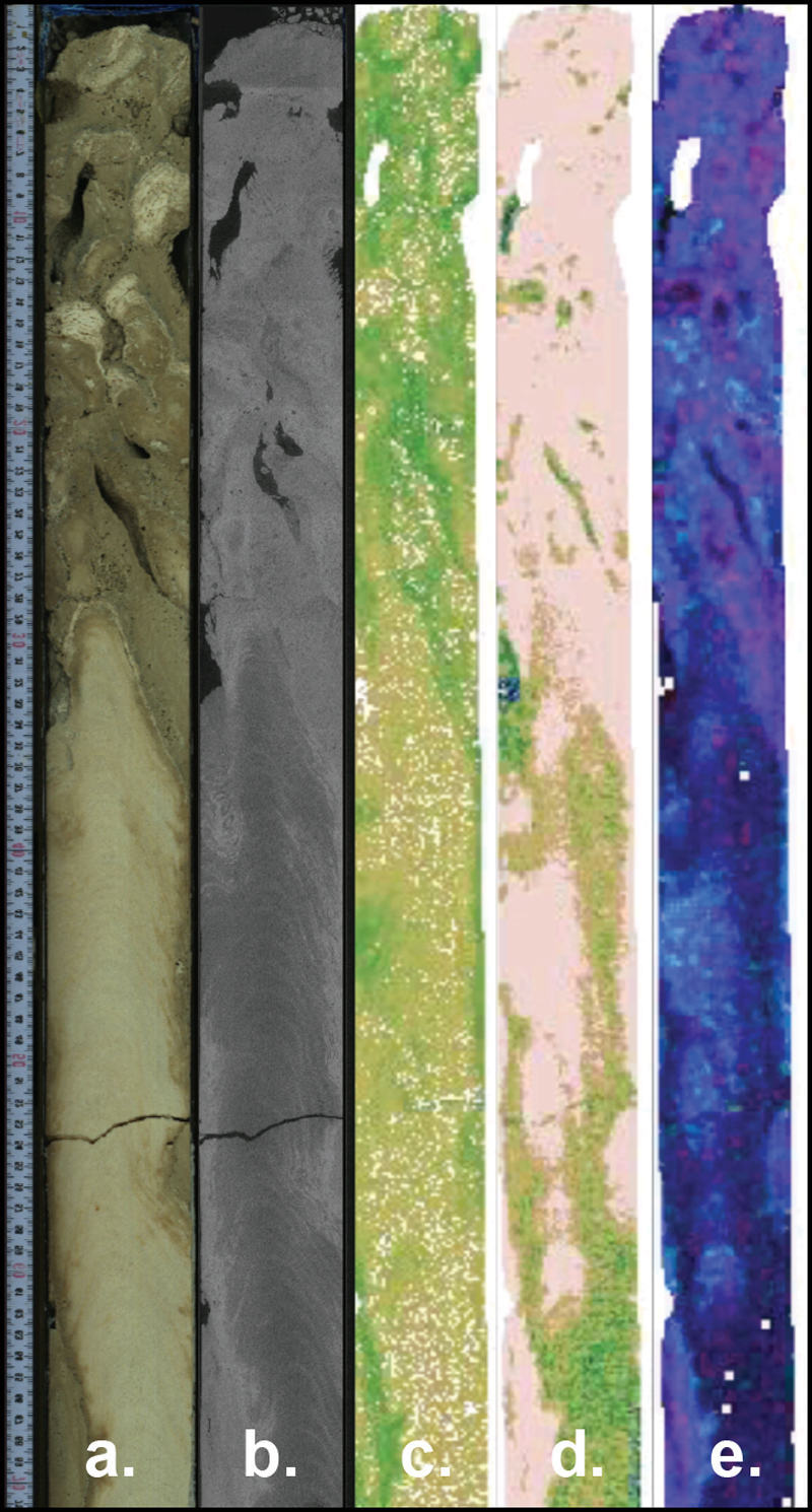
Early analyses of the cores have been done using a suite of nondestructive imaging techniques (Figure 4). X-ray computed tomography is providing 3D reconstructions of massive Porites coral specimens, which often provide accurate records of past ocean conditions. In addition, traditional high-resolution line scans integrated with high-resolution hyperspectral scanning of the cores are revealing carbonate and other minerals (e.g., aragonite, calcite, clay, and iron), helping to guide sampling and more detailed analyses of the cores.
Windows into the Past and Future
The material recovered during X389 is between 10,000 and 500,000 years old and includes hundreds of well-preserved samples. These samples will be used to reconstruct the first absolute dating of sea level changes during portions of this time window. Putting absolute dates to these changes will have profound implications for testing theories about the drivers and triggers of past glacial-interglacial cycles and for validating climate and ice sheet models that are critically important for predicting sea level changes resulting from current and future global warming.
Further, the X389 cores include more than 300 Porites coral specimens with annual banding that will provide the first estimates of seasonal to millennial paleoclimate variability in the region. Geochemical analyses can be used to estimate monthly oceanographic variability with respect to temperature, precipitation, nutrient dynamics, carbon chemistry, and pH.
Assessing the nature of variability at different temporal scales will help answer critical questions. For example, were the occurrence and seasonality of extreme climate events in the past dependent on the background average climate state at times when global temperature, Pacific storm tracks positions, solar insolation, and atmospheric CO2 levels were different? The state dependency of high-frequency temperature and hydroclimate variability is a key question today as Earth warms.
The sequences of reef lithologies recovered during X389, including volcanic flows and the diverse variety and shapes of reef-building organisms, will be interpreted to reveal a story of ecosystem response to geological processes and paleoclimatic variations in sea level and oceanographic conditions. This interpretation will inform broader understanding of the factors that control reef growth, reef health, and coastal resilience in subsiding island settings in the face of future changes in hydroclimate, ocean temperature, nutrient availability, sediment supply, and ocean pH.
The X389 science party is working together to continue studying the collected cores in greater detail to address the project’s scientific goals. And we welcome contributions from external scientists as well: Careful sampling of the cores has left much of the material intact, and as of late February 2025, anyone can request X389 samples from the IODP core repository at Texas A&M University. With concerted and collaborative efforts, we can continue the flexible and inclusive approach of IODP—even as the Sun sets over its current phase—to advance knowledge of the paleoclimate over the past 500,000 years and understanding of what conditions Earth may experience in the future.
Acknowledgments
We thank the entire IODP 389 Expedition Science Party, ECORD Science Operator (ESO) support staff, Benthic drilling team, MMA surveyors, and the captain and crew of the MMA Valour for their outstanding work on the offshore and onshore phases of the expedition. IODP Expedition 389 was supported by funding from the various national funding agencies of the participating IODP countries.
References
Elderfield, H., et al. (2012), Evolution of ocean temperature and ice volume through the mid-Pleistocene climate transition, Science, 337(6095), 704–709, https://doi.org/10.1126/science.1221294.
Lambeck, K., et al. (2014), Sea level and global ice volumes from the Last Glacial Maximum to the Holocene, Proc. Natl. Acad. Sci U. S. A., 111(43) 15,296–15,303, https://doi.org/10.1073/pnas.1411762111.
Rohling, E. J., et al. (2009), Antarctic temperature and global sea level closely coupled over the past five glacial cycles, Nat. Geosci., 2(7), 500–504, https://doi.org/10.1038/ngeo557.
Sanborn, K. L., et al. (2017), New evidence of Hawaiian coral reef drowning in response to meltwater pulse-1A, Quat. Sci. Rev., 175, 60–72, https://doi.org/10.1016/j.quascirev.2017.08.022.
Webster, J. M., et al. (2009), Coral reef evolution on rapidly subsiding margins, Global Planet. Change, 66(1–2), 129–148, https://doi.org/10.1016/j.gloplacha.2008.07.010.
Webster, J. M., et al. (2011), Great Barrier Reef environmental changes, Proc. Integrated Ocean Drill. Program, 325, https://doi.org/10.2204/iodp.proc.325.2011.
Webster, J. M., et al. (2025), Hawaiian drowned reefs, Proc. Int. Ocean Discovery Program, 389, https://doi.org/10.14379/iodp.proc.389.2025.
Author Information
Jody M. Webster ([email protected]), School of Geosciences, Geocoastal Research Group, University of Sydney, Australia; and Christina Ravelo ([email protected]), Ocean Sciences Department, Institute of Marine Sciences, University of California, Santa Cruz